New Mars Forums
You are not logged in.
- Topics: Active | Unanswered
Announcement
#51 2007-06-09 06:48:24
- cIclops
- Member
- Registered: 2005-06-16
- Posts: 3,230
Re: Real images of Mars
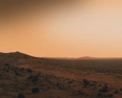
Another beautiful sol on Mars in Gusev crater - MER Opportunity (Pancam)
[color=darkred]Let's go to Mars and far beyond - triple NASA's budget ![/color] [url=irc://freenode#space] #space channel !! [/url] [url=http://www.youtube.com/user/c1cl0ps] - videos !!![/url]
Offline
Like button can go here
#52 2007-06-10 05:38:22
- cIclops
- Member
- Registered: 2005-06-16
- Posts: 3,230
Re: Real images of Mars
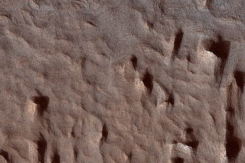
Lots of Layering in Becquerel Crater (MRO/HiRISE) - imaged 5 May 2007
[color=darkred]Let's go to Mars and far beyond - triple NASA's budget ![/color] [url=irc://freenode#space] #space channel !! [/url] [url=http://www.youtube.com/user/c1cl0ps] - videos !!![/url]
Offline
Like button can go here
#53 2007-06-14 10:52:33
- cIclops
- Member
- Registered: 2005-06-16
- Posts: 3,230
Re: Real images of Mars
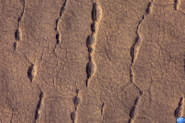
Pits, Cracks, and Polygons in Western Utopia Planitia (MRO/HiRISE) - imaged 1 Jan 2007
[color=darkred]Let's go to Mars and far beyond - triple NASA's budget ![/color] [url=irc://freenode#space] #space channel !! [/url] [url=http://www.youtube.com/user/c1cl0ps] - videos !!![/url]
Offline
Like button can go here
#54 2007-06-17 14:12:30
- cIclops
- Member
- Registered: 2005-06-16
- Posts: 3,230
Re: Real images of Mars

North Polar Cap Edge (Odyssey/THEMIS/False Color) - imaged 26 Nov 2002
[color=darkred]Let's go to Mars and far beyond - triple NASA's budget ![/color] [url=irc://freenode#space] #space channel !! [/url] [url=http://www.youtube.com/user/c1cl0ps] - videos !!![/url]
Offline
Like button can go here
#55 2007-06-22 04:46:19
- cIclops
- Member
- Registered: 2005-06-16
- Posts: 3,230
Re: Real images of Mars
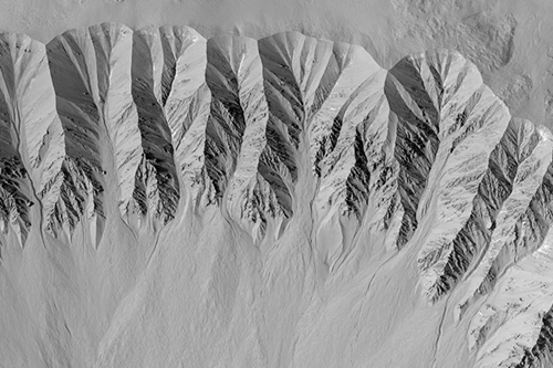
Fresh Crater with Gullies (MRO/HiRISE) - imaged 6 Jun 2007
[color=darkred]Let's go to Mars and far beyond - triple NASA's budget ![/color] [url=irc://freenode#space] #space channel !! [/url] [url=http://www.youtube.com/user/c1cl0ps] - videos !!![/url]
Offline
Like button can go here
#56 2007-06-24 17:13:50
- a1call
- InActive
- From: Montreal
- Registered: 2007-06-24
- Posts: 4
Offline
Like button can go here
#57 2007-07-03 06:29:42
- cIclops
- Member
- Registered: 2005-06-16
- Posts: 3,230
Re: Real images of Mars

Cape St. Vincent, Victoria Crater - MER Opportunity (Pancam) - imaged 6 May 2007
The material at the top of the promontory consists of loose, jumbled rock, then a bit further down into the crater, abruptly transitions to solid bedrock. This transition point is marked by a bright band of rock, visible around the entire crater.
Scientists say this bright band represents what used to be the surface of Mars before it was impacted to form Victoria Crater. As Opportunity begins to descend into the crater in early July 2007, it will examine the band carefully at an accessible location with a gentle slope. These investigations might help determine if the band's brighter appearance is the result of ancient interactions with the Martian atmosphere.
[color=darkred]Let's go to Mars and far beyond - triple NASA's budget ![/color] [url=irc://freenode#space] #space channel !! [/url] [url=http://www.youtube.com/user/c1cl0ps] - videos !!![/url]
Offline
Like button can go here
#58 2007-07-04 01:53:12
- cIclops
- Member
- Registered: 2005-06-16
- Posts: 3,230
Re: Real images of Mars
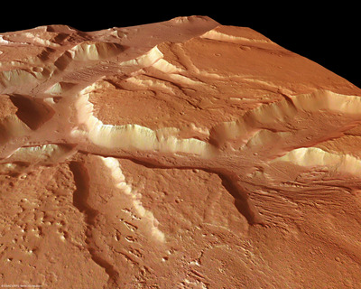
Tectonic signatures at Aeolis Mensae - MEX(HRSC/Digital model) - imaged 26 Mar 2007
Deep valleys are incised into the highlands in the northern part of the scene showing linear features on the floor of the valley. Similar linear features are also seen in the lower part of the picture but the morphology is different from the region in the upper part in that there are no incisions. Also, the area is far less cratered and hence the erosion must be of a relatively recent origin.
Scientists have reason to believe that the valleys might primarily originate from tectonic activity, possibly also modelled locally by subsequent fluid or mass wasting activity.
[color=darkred]Let's go to Mars and far beyond - triple NASA's budget ![/color] [url=irc://freenode#space] #space channel !! [/url] [url=http://www.youtube.com/user/c1cl0ps] - videos !!![/url]
Offline
Like button can go here
#59 2007-07-09 05:13:03
- cIclops
- Member
- Registered: 2005-06-16
- Posts: 3,230
Re: Real images of Mars

Home plate, Gusev Crater - MER Spirit (Pancam) - imaged 17 May 2007
A shallow trench made by Spirit's dragging right front wheel uncovered some of the best evidence Spirit has found for ancient water-rich environments in Gusev Crater -- bright patches of almost pure, fine-grained silica (SiO2). On ancient Earth, warm, evaporating coastal waters deposited fine silica in shallow sediments. In Yellowstone National Park, hot, mineral-laden waters deposit fine-grained silica around geysers and hot springs. The discovery of silica-rich deposits on Mars adds compelling new evidence of ancient environments that might have been favorable for life.
[color=darkred]Let's go to Mars and far beyond - triple NASA's budget ![/color] [url=irc://freenode#space] #space channel !! [/url] [url=http://www.youtube.com/user/c1cl0ps] - videos !!![/url]
Offline
Like button can go here
#60 2007-07-12 01:55:22
- cIclops
- Member
- Registered: 2005-06-16
- Posts: 3,230
Re: Real images of Mars

Outflows from Tiu Vallis and Ares Vallis (Mars Odyssey/THEMIS) - imaged 14 May 2007
The image here combines frames taken during daytime at infrared wavelengths by the Thermal Emission Imaging System (THEMIS) on board NASA's Mars Odyssey orbiter. Circling Mars in a 2-hour orbit, THEMIS scans the surface in 5 visible and 10 infrared bands. This mosaic records the heat radiation coming from the surface, with warmer areas appearing brighter.
[color=darkred]Let's go to Mars and far beyond - triple NASA's budget ![/color] [url=irc://freenode#space] #space channel !! [/url] [url=http://www.youtube.com/user/c1cl0ps] - videos !!![/url]
Offline
Like button can go here
#61 2007-07-20 05:25:01
- cIclops
- Member
- Registered: 2005-06-16
- Posts: 3,230
Re: Real images of Mars
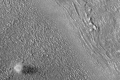
Dust Devil East of Hellas Planitia (MRO/HiRISE) - imaged 6 Jun 2007
Higher resolution images and text
The bright material is the dust within the vortex, and a dark shadow cast by the dust devil is visible to the right. The diameter of this dust devil is about 200 meters, but at the surface it is probably much smaller. Based on the length of the shadow in this image, the dust devil is on the order of 500 meters tall.
[color=darkred]Let's go to Mars and far beyond - triple NASA's budget ![/color] [url=irc://freenode#space] #space channel !! [/url] [url=http://www.youtube.com/user/c1cl0ps] - videos !!![/url]
Offline
Like button can go here
#62 2007-07-27 13:50:04
- cIclops
- Member
- Registered: 2005-06-16
- Posts: 3,230
Re: Real images of Mars
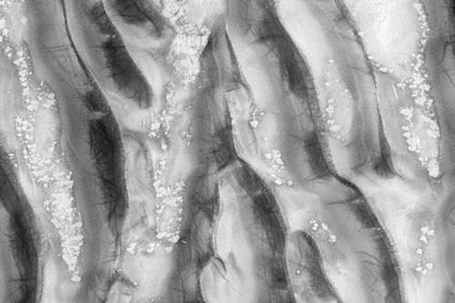
Richardson Crater Dunes, Partially Defrosted (MRO/HiRISE) - imaged 6 Jun 2007
Covered by seasonal carbon dioxide (CO2) frost, the dune field here in Richardson Crater has only partially defrosted, although the image was acquired late in Mars' southern spring.
Large patches of CO2 frost are observed, linked in some places by channels possibly carved into the ground by the erosion of CO2 gas, as blocks dry ice slide down slope and sublimate (evaporate directly from solid to gas). Numerous dust devil tracks have left their mark.
[color=darkred]Let's go to Mars and far beyond - triple NASA's budget ![/color] [url=irc://freenode#space] #space channel !! [/url] [url=http://www.youtube.com/user/c1cl0ps] - videos !!![/url]
Offline
Like button can go here
#63 2007-08-31 06:23:29
- cIclops
- Member
- Registered: 2005-06-16
- Posts: 3,230
Re: Real images of Mars
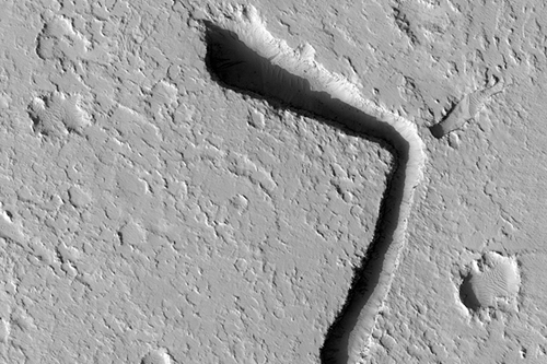
Channels Emanating from Fissure West of Olympus Mons Aureole (MRO/HiRISE) - imaged 4 Apr 2007
[color=darkred]Let's go to Mars and far beyond - triple NASA's budget ![/color] [url=irc://freenode#space] #space channel !! [/url] [url=http://www.youtube.com/user/c1cl0ps] - videos !!![/url]
Offline
Like button can go here
#64 2007-09-01 05:18:01
- cIclops
- Member
- Registered: 2005-06-16
- Posts: 3,230
Re: Real images of Mars
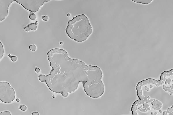
Swiss Cheese Terrain in South Polar Region (MRO/HiRISE) - imaged 8 Aug 2007
Higher resolution images and text
Since Mars is colder than Earth, there is not just water ice at the poles, but also a concentration of carbon dioxide ice. Some of the carbon dioxide ice at the south pole is there all year long and called the residual cap. This image was taken near the south pole of Mars and shows a characteristic "Swiss cheese" pattern.
This pattern is created when there is relatively high, smooth material that is broken up into these circular-shaped depressions forming the "Swiss cheese" terrain. The depressions are thought to be caused by sublimation, which is when a material goes directly from a solid to a gas phase. Repeated images are taken of areas like this so the changes in depression size and where they form can be monitored through the seasons.
[color=darkred]Let's go to Mars and far beyond - triple NASA's budget ![/color] [url=irc://freenode#space] #space channel !! [/url] [url=http://www.youtube.com/user/c1cl0ps] - videos !!![/url]
Offline
Like button can go here
#65 2007-09-02 09:16:26
- cIclops
- Member
- Registered: 2005-06-16
- Posts: 3,230
Re: Real images of Mars

Melas Chasma (Mars Odyssey/THEMIS) - false color image from 13 Aug 2007
The big image above shows the western Melas landing site, which tucks into a small basin below the south rim of Valles Marineris. While the basin is more than 5,000 m (16,000 ft) lower than the south rim, it still stands 1,200 m (4,000 ft) above the floor of Valles Marineris. Geologists describe such a feature as a "perched basin."
According to research by Catherine Weitz (Planetary Science Institute), Cathy Quantin (National Air & Space Museum), and others, the basin likely contains deposits left when it was once filled with a lake. Even long after the lake waters drained away or dried up, such sediments could preserve evidence of former microbial activity, if it existed.
The image is a false-color mosaic of photos taken by the Thermal Emission Imaging System (THEMIS), a multi-wavelength camera on NASA's Mars Odyssey orbiter. As Mars Odyssey flies in a near-polar orbit, THEMIS scans almost all of Mars, capturing its surface in 5 visible colors and 10 infrared ones. This mosaic is made of infrared frames taken by day and by night.
The false colors hint at the nature of the ground surface. Rusty tones show where rocks and hard deposits abound, while greens and blues indicate the areas where gravel, fine sand, and dust particles predominate.
[color=darkred]Let's go to Mars and far beyond - triple NASA's budget ![/color] [url=irc://freenode#space] #space channel !! [/url] [url=http://www.youtube.com/user/c1cl0ps] - videos !!![/url]
Offline
Like button can go here
#66 2007-09-06 05:47:12
- cIclops
- Member
- Registered: 2005-06-16
- Posts: 3,230
Re: Real images of Mars
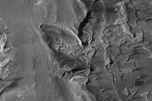
Cross-Cutting Layers in Galle Crater (MRO/HiRISE) - imaged 3 Mar 2007
[color=darkred]Let's go to Mars and far beyond - triple NASA's budget ![/color] [url=irc://freenode#space] #space channel !! [/url] [url=http://www.youtube.com/user/c1cl0ps] - videos !!![/url]
Offline
Like button can go here
#67 2007-09-06 05:49:40
- Yang Liwei Rocket
- Member
- Registered: 2004-03-03
- Posts: 993
Re: Real images of Mars
Some of these images are amazing, fantastic shots !
Thanks for posting them cIclops ![]()
'first steps are not for cheap, think about it...
did China build a great Wall in a day ?' ( Y L R newmars forum member )
Offline
Like button can go here
#68 2007-09-10 06:51:49
- cIclops
- Member
- Registered: 2005-06-16
- Posts: 3,230
Re: Real images of Mars
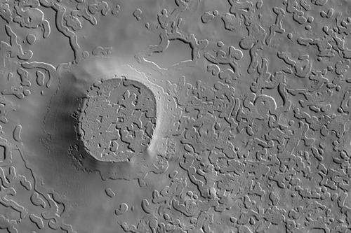
Crater Like Landform in the Southern Residual Cap (MRO/HiRISE) - imaged 3 Mar 2007
[color=darkred]Let's go to Mars and far beyond - triple NASA's budget ![/color] [url=irc://freenode#space] #space channel !! [/url] [url=http://www.youtube.com/user/c1cl0ps] - videos !!![/url]
Offline
Like button can go here
#69 2007-09-14 06:06:34
- cIclops
- Member
- Registered: 2005-06-16
- Posts: 3,230
Re: Real images of Mars
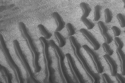
Proctor Crater Dune Field (MRO/HiRISE) - imaged 5 May 2007
[color=darkred]Let's go to Mars and far beyond - triple NASA's budget ![/color] [url=irc://freenode#space] #space channel !! [/url] [url=http://www.youtube.com/user/c1cl0ps] - videos !!![/url]
Offline
Like button can go here
#70 2007-09-17 03:50:11
- cIclops
- Member
- Registered: 2005-06-16
- Posts: 3,230
Re: Real images of Mars
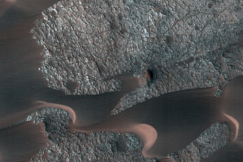
Nili Patera with Bright and Dark Bedrock Exposures Between Dunes (MRO/HiRISE) - imaged 6 Jun 2007
[color=darkred]Let's go to Mars and far beyond - triple NASA's budget ![/color] [url=irc://freenode#space] #space channel !! [/url] [url=http://www.youtube.com/user/c1cl0ps] - videos !!![/url]
Offline
Like button can go here
#71 2007-09-19 07:39:07
- cIclops
- Member
- Registered: 2005-06-16
- Posts: 3,230
Re: Real images of Mars

The mysterious ridges at the mouth of Tiu Valles - MEX(HRSC) - imaged 10 Jun 2007
Higher resolution images and text
Visible in the lower part of the image are remnants of a once 'streamlined' island.
The upper part of the scene covers the mouth of the Tiu Valles nearly in its entire width, approximately 55 km. Its winding, meandering ridges, bound by depressions are eye-catching. The processes that formed these odd structures are unknown. Possibly, during flooding events, water or water-rich surface layers came in contact with lava from the surrounding areas, which then might have led to the formation of these mysterious ridges.
[color=darkred]Let's go to Mars and far beyond - triple NASA's budget ![/color] [url=irc://freenode#space] #space channel !! [/url] [url=http://www.youtube.com/user/c1cl0ps] - videos !!![/url]
Offline
Like button can go here
#72 2007-09-20 06:12:48
- cIclops
- Member
- Registered: 2005-06-16
- Posts: 3,230
Re: Real images of Mars
Hi CyberEnforcer, is that a highly processed MEX/HRSC image? - more details please.
[color=darkred]Let's go to Mars and far beyond - triple NASA's budget ![/color] [url=irc://freenode#space] #space channel !! [/url] [url=http://www.youtube.com/user/c1cl0ps] - videos !!![/url]
Offline
Like button can go here
#73 2007-09-20 06:42:44
- cIclops
- Member
- Registered: 2005-06-16
- Posts: 3,230
Re: Real images of Mars
Interesting effect but most of the detail is lost because the contrast level seems too high, what does the original look like?
[color=darkred]Let's go to Mars and far beyond - triple NASA's budget ![/color] [url=irc://freenode#space] #space channel !! [/url] [url=http://www.youtube.com/user/c1cl0ps] - videos !!![/url]
Offline
Like button can go here
#74 2007-09-20 15:32:00
- cIclops
- Member
- Registered: 2005-06-16
- Posts: 3,230
Re: Real images of Mars

Spectacular Gullies Near Gorgonum Chaos (MRO/HiRISE) - false color image 5 May 2007
Higher resolution images and many more details
... shows incredible details of a crater with gullies that provides strong evidence for gully formation involving fluid flow.
[color=darkred]Let's go to Mars and far beyond - triple NASA's budget ![/color] [url=irc://freenode#space] #space channel !! [/url] [url=http://www.youtube.com/user/c1cl0ps] - videos !!![/url]
Offline
Like button can go here
#75 2007-09-20 15:46:04
- cIclops
- Member
- Registered: 2005-06-16
- Posts: 3,230
Re: Real images of Mars

North Polar Layered Deposits (MRO/HiRISE) - false color image 12 Dec 2006
Video Exploration of Details - image zoom and pan 3:48 mins (various QT resolutions)
- try the high resolution version and fill your mind with Mars!
[color=darkred]Let's go to Mars and far beyond - triple NASA's budget ![/color] [url=irc://freenode#space] #space channel !! [/url] [url=http://www.youtube.com/user/c1cl0ps] - videos !!![/url]
Offline
Like button can go here
