New Mars Forums
You are not logged in.
- Topics: Active | Unanswered
Announcement
#151 Re: Not So Free Chat » Vincent Weather, US » 2012-10-25 09:09:34
12Z up-date
Sandy will move NE today with a gradual decrease in forward motion. A drift to the west is expected after 12 hours in response to a building ridge off the East coast of New England.
As dry air is entrained Sandy will lose some of her tropical characteristics and become extra tropical. Back in the day we would call these type storms "Himicanes."
Expect Gail force winds on the coast of North Carolina, with Storm force winds along the outer-banks and off shore in 72 hrs. Seas 20-35 feet and higher.
NWS Bulletin* Immediate Broadcast Requested*
Special Weather Statement
ANZ088-251500-
CAPE FEAR TO 31N OUT TO 32N 73W TO 31N 74W
500 AM EDT THU OCT 25 2012
TROPICAL STORM WARNING
HURRICANE CONDITIONS EXPECTED SAT INTO SUN
TODAY
E TO NE WINDS 10 TO 20 KT INCREASING TO 15 TO 25 KT.
SEAS 3 TO 7 FT BUILDING TO 6 TO 11 FT LATE. HIGHEST WINDS AND
SEAS S.
TONIGHT
E TO NE WINDS INCREASING TO 20 TO 30 KT. SEAS
BUILDING TO 8 TO 16 FT LATE. HIGHEST WINDS AND SEAS SE.
SCATTERED SHOWERS AND TSTMS DEVELOPING LATE.
FRI
E TO NE WINDS INCREASING TO 25 TO 35 KT...EXCEPT OVER FAR
SE PORTION TO 35 TO 45 KT LATE. SEAS BUILDING TO 12 TO 24 FT...
HIGHEST SE. SCATTERED SHOWERS AND TSTMS BECOMING NUMEROUS.
FRI NIGHT
FAR NW PORTION...NE WINDS INCREASING TO 30 TO 40
KT. SEAS 14 TO 22 FT. ELSEWHERE...E TO NE WINDS INCREASING TO 40
TO 55 KT. SEAS BUILDING TO 20 TO 30 FT. HIGHEST WINDS AND SEAS
SE. NUMEROUS SHOWERS AND SQUALLS THROUGHOUT...OCCASIONALLY
REDUCING VSBY BELOW 1 NM.
SAT
W PORTION...NE TO N WINDS 30 TO 45 KT. SEAS 15 TO 24 FT.
E PORTION...E TO NE WINDS INCREASING TO 45 TO 65 KT. SEAS 22 TO
34 FT. HIGHEST WINDS AND SEAS SE.
SUN
TROPICAL STORM CONDITIONS EXPECTED...EXCEPT OVER W
PORTION BECOMING NW WINDS 25 TO 35 KT LATE. SEAS BECOMING 9 TO
18 FT... EXCEPT E OF 1000 FM 18 TO 30 FT LATE...HIGHEST E.
MON
W TO NW WINDS DIMINISHING TO 20 TO 30 KT. SEAS SUBSIDING
TO 7 TO 12 FT...EXCEPT E OF 1000 FM 12 TO 17 FT...HIGHEST E.
$$
#152 Re: Not So Free Chat » Vincent Weather, US » 2012-10-25 04:47:10
Hurricane Sandy Heads into the Bahamas
Hurricane Sandy will lurk off the East Coast of the US next 72 hrs. Modified Arctic air digs southeast along the front range with a period of moderate to heavy snow from Colorado NE into Minnesota, today. This storm will intensify in the Hudson Bay. This will develop a negative tilt and 300 mb level trof into the central East Coast 72-86 hrs. This will guide Sandy on shore somewhere from the DELMARVA to the Gulf of Maine.
Those that live in these areas should prepare now for a major storm with winds up to 75 mph with higher gust, coastal flooding and power outages within 96-144 hrs.
Vincent
#153 Re: Not So Free Chat » Vincent Weather, US » 2012-10-25 04:43:22
Hurricane Sandy Heads into the Bahamas
Hurricane Sandy will lurk off the East Coast of the US next 72 hrs. Modified Arctic air digs southeast along the front range with a period of moderate to heavy snow from Colorado NE into Minnesota, today. This storm will intensify in the Hudson Bay. This will develop a negative tilt and 300 mb level trof into the central East Coast 72-86 hrs. This will guide Sandy on shore somewhere from the DELMARVA to the Gulf of Maine.
Those that live in these areas should prepare now for a major storm with winds up to 75 mph with higher gust, coastal flooding and power outages within 96 hrs.
Vincent
#154 Re: Not So Free Chat » Vincent Weather, US » 2012-10-22 17:05:25
18Z GFS, still off the chain. Is it right?
Vincent
#155 Re: Not So Free Chat » what is a "ghost" ? » 2012-10-22 15:40:01
Brother, you need to know the power of the Mind. Christ put that crap to rest 2000 years ago.
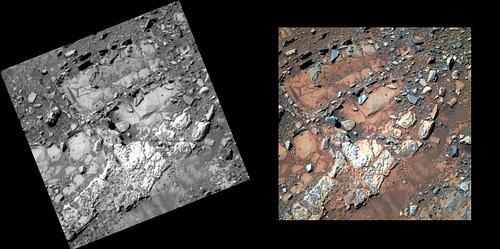
#156 Re: Unmanned probes » Mars Exploration Rovers (MER) » 2012-10-22 15:05:56
Opportunity sol 3104 ( Oct 17, 2012 ) 3D of rock and soil on Cape York, Endeavour crater, Meridiani Plain, Mars. From hort.
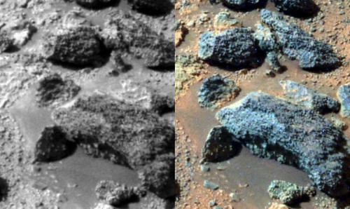
s-1P403746181ESFBWEGP2589L257R2regT-c1 by hortonheardawho, on Flickr
#157 Re: Not So Free Chat » Vincent Weather, US » 2012-10-22 15:00:51
18Z NAM shows sharp trof at 84 hrs. Consistent with NOGAPS.
Vincent
#158 Re: Not So Free Chat » Vincent Weather, US » 2012-10-22 14:16:22
Latest data shows ECMWF into NYC with Storm force winds 0C isotherm well noth and west. CMS shows Hurricane force winds into eastern Maryland with 0C isotherm digging southeast into western NC. Navy NOGAPS takes it into Nantucket with heavy snow developing in the high country of NC, WV. I like that. Seems reasonable. GFS the outlier.
Vincent
#159 Re: Unmanned probes » Mars Exploration Rovers (MER) » 2012-10-22 13:07:15
Opportunity sol 3104 ( Oct 17, 2012 ) 3D of rock and soil on Cape York, Endeavour crater, Meridiani Plain, Mars
From hort....
diggin up bones.....I hate it when i do this..
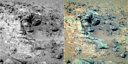
s-1P403745318EFFBWEGP2412L257R2regT by hortonheardawho, on Flickr
#160 Re: Not So Free Chat » Vincent Weather, US » 2012-10-22 12:01:23
A little Northeast, will up-date during the storm.
#161 Re: Not So Free Chat » Vincent Weather, US » 2012-10-22 11:54:58
Surface observations will update. Moderate to heavy snow in the Seiara Nevada, moves NE.
#162 Re: Not So Free Chat » Vincent Weather, US » 2012-10-22 10:37:47
GFS was the outlier, with cyclogenesis well off the coast. It trends as such. CMS and ECMWF need to man-up. Details after 3PM EDT or 20Z.
Vincent
#163 Re: Pictures of Mars » Mars Video » 2012-10-22 10:06:02
I will repost the original video link. As Isaac Newton ( I hope you know who that is) said, "I stand on the shoulders of giants."
Think for just a moment of all the men , whose work, made this video possible.
Vincent
#164 Re: Pictures of Mars » Mars Video » 2012-10-22 09:54:52
Thanks for reminding me how old I am. The white hair and rooting teeth should have been a clue to me. So much for denial.....
Vincent
#165 Re: Unmanned probes » Mars Exploration Rovers (MER) » 2012-10-22 09:34:13
Opportunity sol 3105 ( Oct 18, 2012 ) 180 degree panorama looking east on Cape York, Endeavour crater, Meridiani Plain, Mars.
From Hort. Must view original size to appreciate.
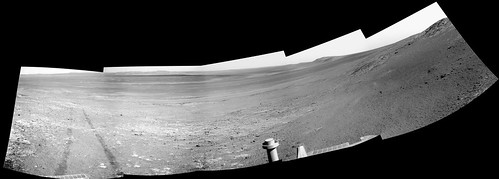
p-1N403836047EFFBWISP1627L0sqtv-5 by hortonheardawho, on Flickr
#166 Re: Pictures of Mars » Mars Video » 2012-10-22 09:09:10
His influence on me was great. I think this video with his narration, says it all.
#167 Re: Pictures of Mars » Mars Video » 2012-10-22 09:05:07
That is Carl Sagan. The Pathfinder site was designated, Carl Sagan Memorial Station. I felt obliged to show his image there at the Pathfinder site.
Vincent
#168 Re: Unmanned probes » Official MSL / Curiosity Rover Thread | Aug 5, 2012 10:31 p.m. PT » 2012-10-22 08:43:59
Animation of false color enhanced image of vibration and dump of scoop 4. Must view original size to see animation, from Hort. Geeze, they better have a dang good reason to hold us hostage for two weeks in that pile of dust.
Vincent
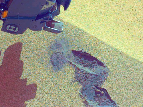
0074ML0501000000E1_DXXX_G+4xd_a2-c1 by hortonheardawho, on Flickr
#169 Re: Not So Free Chat » Vincent Weather, US » 2012-10-22 08:07:58
This will be wild week for the lower 48. Modified arctic air moves south and east into Montana by Wednesday on the back-side of a potent winter storm for the high-country from California, Utah , Colorado, north and east . Snow totals will be measured in feet.
Indian summer conditions begin today for the eastern third. Temps will approach the low 80' from Washington DC and points south by Wednesday. Meanwhile conditions become favorable for tropical development as an area of disturbed weather moves north to a position off the east coast of Florida. Hurricane conditions seem likely 75-100 miles off-shore.
To summarize . Modified arctic air moves toward the east coast this weekend. Strong tropical storm or Hurricane moves toward the coast of North Carolina. Long wave trof develops in advance of cold air and could develop cut-off 300mb level reflection over southeastern US.
Could be a hell of a storm along the east coast into New England. "Katie, bar the door."
Vincent
#170 Re: Not So Free Chat » Vincent Weather, US » 2012-10-22 04:25:00
Polar ice pack and N Hemi snow pack monitoring, last image, 21 Oct 2012

#171 Re: Not So Free Chat » Vincent Weather, US » 2012-10-19 10:03:24
Indian summer, on the way to the eastern seaboard. After a warm event ends with temps in the 60's this weekend, long wave trof develops in the Rockies this weekend. High pressure develops on the eastern seaboard and warm air advection begins. Temps in the 70's F or 20-25C during the day with upper 40's 8-12C at night.
A developing storm will usher in cold air 7-10 days out. Significant snow in the high plains and Great Lakes in advance.
Don't want to dismiss the Mars like weather on the high plains this week. Winds 50-60 mph with visibilities 1/2 mile in blowing dust, as storm center moves south of the lakes today.
Vincent
#172 Re: Not So Free Chat » Vincent Weather, US » 2012-10-19 08:23:13
I was pondering why meteorologist and geologist are different. I think it is "time." Time is a measurement, that can be manipulated by man. Time lapse photography should be implemented by geologist. You may not live to see the final product, but us meteorologist sure can. Invest now, we do.
As you know the sun has set at the north pole. Time lapse data shows the rapid refreeze of the Arctic ocean. This is witness to a subtle difference between the freezing point and thaw point.
This link is a little further south and you can watch as the Arctic night progresses south to the northern most point of the United States, Pt Barrow Alaska. Here you will find not only a live weather cam, but "time lapse" movies of years past, enjoy.
Enjoy the rapid process of atmospheric dynamics.
Vincent
#173 Re: Unmanned probes » Mars Exploration Rovers (MER) » 2012-10-19 07:52:03
Opportunity sends back impressive image of "fracture fill" on steroids, while Curiosity continues to be held hostage by geologist. Cross eyed 3D from Hort.
Opportunity sol 3103 ( Oct 16, 2012 ) 3D of rocks and soil on Cape York, Endeavour crater, Meridiani Plain, Mars.
s-1P403655364ESFBWCRP2587L257R2regT by hortonheardawho, on Flickr
#174 Re: Unmanned probes » Official MSL / Curiosity Rover Thread | Aug 5, 2012 10:31 p.m. PT » 2012-10-18 11:49:45
3D of trench...
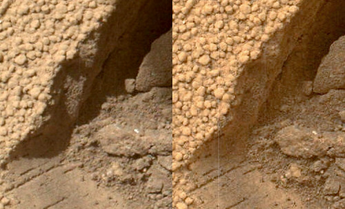
0066MH0075001000E2_DXXX_s-c1 by hortonheardawho, on Flickr
#175 Re: Not So Free Chat » Vincent Weather, US » 2012-10-18 05:06:14
Polar ice pack and N Hemi snow pack monitoring.
Also, Gickr does not allow for bigger images or a link. A handy tool to magnify web images is available here. It's great for Mars images.
http://magnifier.sourceforge.net/
