New Mars Forums
You are not logged in.
- Topics: Active | Unanswered
Announcement
#102 Re: Life on Mars » Curiosity team find ancient habitable environment » 2013-03-31 16:08:40
Yea man, we all knew, like this is a concretion......
#103 Re: Unmanned probes » Official MSL / Curiosity Rover Thread | Aug 5, 2012 10:31 p.m. PT » 2013-03-31 15:26:11
I don't know where everyone else went but I get tired sometime. I guess the other guys do as well. We all have ideologies and seek witness to them. We perceive, not see, through the lens of them. We will see the witnesses we call fourth. This is not vision.
Organics have been found in every sample that they no longer sterilize. The discovery of perchlorates have moved us forward. Tip of the hat to Phoenix.
In the end Levin's experiment on Viking will prove the existence of microorganisms. This simply means that life is universal and the Universe is life. The self we hold so dear is nothing more than a complex protein in the cosmic scheme.
Evolution will move from biological to nonbiological. Consciousness is experienced with memory. We create as we were created, maybe not in form, but, liken to. We will create in our likeness as our creator created in His. We are His Son......
The really cool pictures have been released. The question of whether Mars was every suitable for simple life has been answered. The presence of organics is no longer in question. They have more images no doubt, we should live long enough to see them, I hope.
Vincent
#104 Re: Life on Mars » Past and Present life on Mars » 2012-11-05 17:11:16
#105 Re: Unmanned probes » Official MSL / Curiosity Rover Thread | Aug 5, 2012 10:31 p.m. PT » 2012-11-05 11:57:50
Tell me about the green bother. That is the data comparision. See the green......Good to have you here GW.....
#106 Re: Not So Free Chat » Vincent Weather, US » 2012-11-05 10:32:35
Nor'easter seems likely. This will be a nuisance to the recovery efforts. Max winds 40-50 mph. Rain on the coast will mix with snow at times inland from Baltimore, and points north and west, on Wednesday.
Snowfall totals 4-8 inches in the high country of West Virginia, Maryland, Penn state, and New England.
Major winter storm gathers in the Rockies late week.. Temperatures falling to -15F with wind driven snow in Montana. Snow totals 1-2 feet, then blowing and drifting snow.
Vincent
#107 Re: Unmanned probes » Official MSL / Curiosity Rover Thread | Aug 5, 2012 10:31 p.m. PT » 2012-11-05 10:19:24
#108 Re: Not So Free Chat » Vincent Weather, US » 2012-11-02 13:14:30
ECMF is a statistical outlier. It is, however, a major model. It suggest moderate to heavy snow in Western Maryland, Pennsylvania and New York state.
Vincent
http://www.youtube.com/watch?v=aqlJl1LfDP4

#109 Re: Not So Free Chat » Vincent Weather, US » 2012-11-02 12:07:01
Apologies,
There is a fine line between genius and insanity. Unfortunately on occasion you will see me drift over the line. I try to clean up when I can. This forum does allow for that and I am grateful. Music is an outlet for me. I can get artsy.....
Next storm in the Rockies.......
Sometimes I play with the dust that dance in the beams in the window....
Vincent
#110 Re: Unmanned probes » Official MSL / Curiosity Rover Thread | Aug 5, 2012 10:31 p.m. PT » 2012-11-02 11:52:55
Sounds like they are in denial, with methane readings. They reduced them to nothing. Seasonal plumes suggest biological vs. geological.
#111 Re: Not So Free Chat » Vincent Weather, US » 2012-11-02 11:41:42
Consensus of 12Z data with known climatology shows a brief intense storm off Hatteras, 995mb storm with winds 40mph moving northeast with main precip band off the coast, Moderate to heavy snow possible over Maine and the gulf of Maine as storm rotates with cut-off 500mb vort max.
Light snow in the Appalachians, 2-4 inches.
Next major storm in the Rockies 7-10 days.
Vincent
#112 Re: Not So Free Chat » Vincent Weather, US » 2012-11-02 10:30:28
There are rumors of a Nor'easter for the mid-Atlantic mid-week. This is only potential. There are hints that the 500mb long wave trof may fragment and a cut-off vortex would develop. This would retard necessary thermal dynamics and send the vort max meandering off the coast and into the Canadian Maritimes.
In other words the models diverge. Let's not scare the people. Worst case scenario, 995mb low off Nantucket. That's 40 mbs higher and 75 nautical miles further east than Sandy. Max wind 50 kts vs., max wind 100 kts with Sandy.
After Sandy, one could call this a stable wave.....
No nose bleed intended.....
Vincent
#113 Re: Unmanned probes » Official MSL / Curiosity Rover Thread | Aug 5, 2012 10:31 p.m. PT » 2012-11-02 09:27:44
PASADENA, Calif. -- NASA will host a media teleconference at 10 a.m. PDT (1 p.m. EDT) on Friday, Nov. 2, to provide an update on Curiosity's studies of the Martian atmosphere.
The Mars Science Laboratory Project and its Curiosity rover are about three months into a two-year prime mission to investigate whether conditions in Mars' Gale Crater may have been favorable for microbial life.
Audio and visuals of the event will be streamed live online at: http://www.nasa.gov/newsaudio and http://www.ustream.tv/nasajpl .
Visuals will be available at the start of the event at: http://go.nasa.gov/curiositytelecon .
For information about NASA's Curiosity mission, visit: http://www.nasa.gov/mars and http://mars.jpl.nasa.gov/msl .
DC Agle / Guy Webster 818-354-5011
Jet Propulsion Laboratory, Pasadena, Calif.
agle@jpl.nasa.gov / guy.webster@jpl.nasa.gov
Dwayne Brown 202-358-1726
NASA Headquarters, Washington
Dwayne.c.brown@nasa.gov
#114 Re: Not So Free Chat » Vincent Weather, US » 2012-11-02 09:24:34
Kerouac himself would get a nose bleed from this stream of consciousness.
You sort of got to know how I get down. I usually clean up the noise the next morning but I lost power. They said they had to bring us down to replace a major component that flooded out, down line. Just got power back and did a little house cleaning.
One room of carpet was a total loss. Had to have the padding removed and subfloor treated so no mold would develop.
That was a hell of a storm.....
Vincent
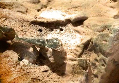
#115 Re: Unmanned probes » Official MSL / Curiosity Rover Thread | Aug 5, 2012 10:31 p.m. PT » 2012-10-30 09:37:26
As the storm moves NW, let's talk Mars. News conference 2:30 EDT today. Will they throw us a bone? Let's hope so.....Anyone know how to dry carpet?.......
Curiosity sol 0082 MAHLI false color cross-eyed 3D of rock in the Glenelg area of Gale crater, Mars. From Hort.
http://www.youtube.com/watch?v=HUK1fWWR84E
Vincent

0082MH0096001003E1_DXXX_s-c1_a by hortonheardawho, on Flickr
#116 Re: Not So Free Chat » Vincent Weather, US » 2012-10-30 09:19:00
Storm Warning
--------------------------------------------------------------------------------
URGENT - MARINE WEATHER MESSAGE
NATIONAL WEATHER SERVICE CHICAGO IL
1014 AM CDT TUE OCT 30 2012
LMZ080-261-362-364-366-563-565-567-669-671-673-675-777-779-868-
870-872-874-876-878-302315-
/O.CON.KLOT.SR.W.0003.000000T0000Z-121030T2100Z/
/O.CON.KLOT.GL.W.0050.121030T2100Z-121101T0200Z/
LAKE MICHIGAN FROM MICHIGAN CITY IN TO ST. JOSEPH MI 5 NM
OFFSHORE TO MID LAKE-
LAKE MICHIGAN FROM SEUL CHOIX POINT TO ROCK ISLAND PASSAGE 5 NM
OFFSHORE TO MID LAKE-
LAKE MICHIGAN SOUTH OF A LINE FROM SEUL CHOIX POINT TO THE
MACKINAC BRIDGE AND NORTH OF A LINE FROM CHARLEVOIX MI TO SOUTH
FOX ISLAND 5 NM OFFSHORE-
LAKE MICHIGAN FROM CHARLEVOIX TO POINT BETSIE MI 5 NM OFFSHORE TO
MID LAKE-
LAKE MICHIGAN FROM POINT BETSIE TO MANISTEE MI 5 NM OFFSHORE TO
MID LAKE-
LAKE MICHIGAN FROM ROCK ISLAND PASSAGE TO STURGEON BAY WI-
LAKE MICHIGAN FROM STURGEON BAY TO TWO RIVERS WI 5 NM OFFSHORE TO
MID LAKE-
LAKE MICHIGAN FROM TWO RIVERS TO SHEBOYGAN WI 5 NM OFFSHORE TO
MID LAKE-
LAKE MICHIGAN FROM SHEBOYGAN TO PORT WASHINGTON WI 5 NM OFFSHORE
TO MID LAKE-
LAKE MICHIGAN FROM PORT WASHINGTON TO NORTH POINT LIGHT WI 5 NM
OFFSHORE TO MID LAKE-
LAKE MICHIGAN FROM NORTH POINT LIGHT TO WIND POINT WI 5 NM
OFFSHORE TO MID LAKE-
LAKE MICHIGAN FROM WIND POINT WI TO WINTHROP HARBOR IL 5 NM
OFFSHORE TO MID LAKE-
LAKE MICHIGAN FROM WINTHROP HARBOR TO WILMETTE HARBOR IL 5 NM
OFFSHORE TO MID LAKE-
LAKE MICHIGAN FROM WILMETTE HARBOR IL TO MICHIGAN CITY IN 5 NM
OFFSHORE TO MID LAKE-
LAKE MICHIGAN FROM PENTWATER TO MANISTEE MI 5 NM OFFSHORE TO MID
LAKE-
LAKE MICHIGAN FROM WHITEHALL TO PENTWATER MI 5 NM OFFSHORE TO MID
LAKE-
LAKE MICHIGAN FROM GRAND HAVEN TO WHITEHALL MI 5 NM OFFSHORE TO
MID LAKE-
LAKE MICHIGAN FROM HOLLAND TO GRAND HAVEN MI 5 NM OFFSHORE TO MID
LAKE-
LAKE MICHIGAN FROM SOUTH HAVEN TO HOLLAND MI 5 NM OFFSHORE TO MID
LAKE-
LAKE MICHIGAN FROM ST. JOSEPH TO SOUTH HAVEN MI 5 NM OFFSHORE TO
MID LAKE-
1014 AM CDT TUE OCT 30 2012
...STORM WARNING REMAINS IN EFFECT UNTIL 4 PM CDT THIS
AFTERNOON...
...GALE WARNING REMAINS IN EFFECT FROM 4 PM THIS AFTERNOON TO
9 PM CDT WEDNESDAY...
FOR ALL OPEN WATERS...
* WINDS...NORTH STORM FORCE TO 50 KT TODAY...NORTH GALES TO 45 KT
TONIGHT...NORTH GALES TO 40 KT WEDNESDAY.
* SIGNIFICANT WAVES...19 TO 24 FT TODAY...SUBSIDING TO 14 TO 18 FT
TONIGHT.
* OCCASIONAL WAVES...TO 31 FT TODAY...SUBSIDING TO 24 FT TONIGHT.
PRECAUTIONARY/PREPAREDNESS ACTIONS...
A STORM WARNING MEANS WINDS OF 48 TO 63 KNOTS ARE IMMINENT OR
OCCURRING. RECREATIONAL BOATERS SHOULD REMAIN IN PORT...OR TAKE
SHELTER UNTIL WINDS AND WAVES SUBSIDE. COMMERCIAL VESSELS SHOULD
PREPARE FOR VERY STRONG WINDS AND DANGEROUS SEA CONDITIONS...AND
CONSIDER REMAINING IN PORT OR TAKING SHELTER IN PORT UNTIL WINDS
AND WAVES SUBSIDE.
A GALE WARNING MEANS WINDS OF 34 TO 47 KNOTS ARE IMMINENT OR
OCCURRING. OPERATING A VESSEL IN GALE CONDITIONS REQUIRES
EXPERIENCE AND PROPERLY EQUIPPED VESSELS. IT IS HIGHLY
RECOMMENDED THAT MARINERS WITHOUT THE PROPER EXPERIENCE SEEK
SAFE HARBOR PRIOR TO THE ONSET OF GALE CONDITIONS.
#117 Re: Not So Free Chat » Vincent Weather, US » 2012-10-30 09:01:12
This is a infrared(IR) Sat Loop. This shows that Sandy has transitioned to a cold core Winter Storm.....You can adjust animation speed
http://weather.rap.ucar.edu/satellite/d … duration=5
Visible loop
#118 Re: Not So Free Chat » Vincent Weather, US » 2012-10-30 08:47:05
Water intrusion has abated, so we are holding our own. Occasional rain showers and a few sleet pellets continue with winds SW at 15 Gust to 25. Wind chills -1C. That's Gale Crater weather....
Storm center 90 miles west of Philadelphia drifting west at 15 mph. Winds gusting to 40 mph in NY City at 10AM local, with gust to 50 mph off shore.
Blizzard and Winter Storm warnings continue from Western Maryland to the high country of NC. Gale warnings out for all the great lakes except Lake Michigan that has up-graded to Storm Warnings for winds above 50 mph.
For those that want to watch the snow fall in North Carolina, try this link.
Vincent
#119 Re: Not So Free Chat » Vincent Weather, US » 2012-10-30 06:07:00
Was thinking for awhile all was well, but my residence is "taking on water." The carpet is slushy, dang. Light rain and ice pellets at 12Z, temp 38F.
#120 Re: Not So Free Chat » Vincent Weather, US » 2012-10-30 04:00:40
Power is on!!! The lights do however, still flicker. Rainfall totals so far 8.75 inches. Current wind gust 32mph, temperature 39F and falling. 272,835 souls still in the dark in Baltimore, 7,000,000 in the NE. Peak wind 58mph during storm at BWI.
Vincent lives.....
#121 Re: Not So Free Chat » Vincent Weather, US » 2012-10-29 10:35:00
12Z data shows the center of the storm passing over my house (20 miles north of Baltimore) at about 1:30 or 1:45AM local time. I have charged everything you can charge. Got a big quilt for the recliner. Temperatures fall into the 30'sF or 3C by 9AM local with 40-50mph winds. That's cold man, that's cold.....
Sandy has set a new record low pressure for above 36 degrees north latitude, 943 mbs.
This link should bring her home.....
Good luck to me.....
Vincent
#122 Re: Not So Free Chat » Vincent Weather, US » 2012-10-29 02:47:53
It sort of feels like a deep dread as Sandy makes her transition to "super storm" and she's heading toward me, sardines and flashlights at the ready. Yikes!
SUMMARY OF 200 AM EDT...0600 UTC...INFORMATION
----------------------------------------------
LOCATION...35.2N 70.5W
ABOUT 280 MI...455 KM E OF CAPE HATTERAS NORTH CAROLINA
ABOUT 425 MI...685 KM SSE OF NEW YORK CITY
MAXIMUM SUSTAINED WINDS...75 MPH...120 KM/H
PRESENT MOVEMENT...N OR 10 DEGREES AT 14 MPH...22 KM/H
MINIMUM CENTRAL PRESSURE...950 MB...28.05 INCHES
URGENT - MARINE WEATHER MESSAGE
NATIONAL WEATHER SERVICE BALTIMORE MD/WASHINGTON DC
439 AM EDT MON OCT 29 2012
ANZ530>534-537>543-291645-
/O.CON.KLWX.HF.W.0001.000000T0000Z-121031T0000Z/
CHESAPEAKE BAY NORTH OF POOLES ISLAND MD-
CHESAPEAKE BAY FROM POOLES ISLAND TO SANDY POINT MD-
CHESAPEAKE BAY FROM SANDY POINT TO NORTH BEACH MD-
CHESAPEAKE BAY FROM NORTH BEACH TO DRUM POINT MD-
CHESAPEAKE BAY FROM DRUM POINT MD TO SMITH POINT VA-
TIDAL POTOMAC FROM COBB ISLAND MD TO SMITH POINT VA-
PATAPSCO RIVER INCLUDING BALTIMORE HARBOR-
CHESTER RIVER TO QUEENSTOWN MD-EASTERN BAY-
CHOPTANK RIVER TO CAMBRIDGE MD AND THE LITTLE CHOPTANK RIVER-
PATUXENT RIVER TO BROOMES ISLAND MD-
TANGIER SOUND AND THE INLAND WATERS SURROUNDING BLOODSWORTH
ISLAND-
439 AM EDT MON OCT 29 2012
...HURRICANE FORCE WIND WARNING REMAINS IN EFFECT UNTIL 8 PM EDT
TUESDAY...
A HURRICANE FORCE WIND WARNING REMAINS IN EFFECT UNTIL 8 PM EDT
TUESDAY.
* WINDS...64 KNOTS OR GREATER WITHIN THE HURRICANE FORCE WIND
WARNING.
PRECAUTIONARY/PREPAREDNESS ACTIONS...
A HURRICANE FORCE WIND WARNING MEANS WINDS OF 64 KNOTS OR GREATER
ARE IMMINENT OR OCCURING. ALL VESSELS SHOULD REMAIN IN PORT...OR
TAKE SHELTER AS SOON AS POSSIBLE...UNTIL WINDS AND WAVES SUBSIDE.
--------------------------------------------------------------------------------------------------------------
URGENT - WINTER WEATHER MESSAGE
NATIONAL WEATHER SERVICE BALTIMORE MD/WASHINGTON DC
327 AM EDT MON OCT 29 2012
...ACCUMULATING SNOWFALL AND HIGH WIND EXPECTED FOR THE HIGHER
ELEVATIONS...
.POST TROPICAL CYCLONE SANDY WILL INTERACT WITH A COLD UPPER LOW
AND RESULT IN HEAVY SNOW AND HIGH WIND OVER THE HIGHER ELEVATIONS.
VAZ503-504-WVZ501-503-505-506-291530-
/O.CON.KLWX.BZ.W.0001.121029T2000Z-121031T1200Z/
WESTERN HIGHLAND-EASTERN HIGHLAND-WESTERN GRANT-WESTERN MINERAL-
WESTERN PENDLETON-EASTERN PENDLETON-
INCLUDING THE CITIES OF...HIGHTOWN...MONTEREY...BAYARD...
MOUNT STORM...ELK GARDEN...CIRCLEVILLE...FRANKLIN
327 AM EDT MON OCT 29 2012
...BLIZZARD WARNING REMAINS IN EFFECT FROM 4 PM THIS AFTERNOON TO
8 AM EDT WEDNESDAY...
* PRECIPITATION TYPE...HEAVY WET SNOW.
* ACCUMULATIONS...6 TO 12 INCHES THROUGH TUESDAY. AMOUNTS WILL BE
ELEVATION DEPENDENT - WITH THE HIGHER TOTALS OCCURRING ABOVE 2000
FEET. ADDITIONAL ACCUMULATIONS EXPECTED TUESDAY NIGHT.
* TIMING...RAIN CHANGING TO SNOW LATE THIS AFTERNOON AND THEN CONTINUING
UNTIL WEDNESDAY MORNING.
* TEMPERATURES...AROUND FREEZING.
* WINDS...WEST 25 TO 35 MPH WITH GUSTS UP TO 60 MPH.
* IMPACTS...IT IS LIKELY THAT THE COMBINATION OF STRONG WIND AND
HEAVY WET SNOW WILL DOWN TREE LIMBS AND POWER LINES. EXPECT NEAR
ZERO VISIBILITIES IN PERIODS OF HEAVY SNOW.
PRECAUTIONARY/PREPAREDNESS ACTIONS...
A BLIZZARD WARNING MEANS SEVERE WINTER WEATHER CONDITIONS ARE
EXPECTED OR OCCURRING. FALLING AND BLOWING SNOW WITH STRONG WINDS
AND POOR VISIBILITIES ARE LIKELY. THIS WILL LEAD TO WHITEOUT
CONDITIONS...MAKING TRAVEL EXTREMELY DANGEROUS. DO NOT TRAVEL. IF
YOU MUST TRAVEL...HAVE A WINTER SURVIVAL KIT WITH YOU. IF YOU GET
STRANDED...STAY WITH YOUR VEHICLE.
#123 Re: Not So Free Chat » Vincent Weather, US » 2012-10-27 17:56:58
Er....They are catching up....
URGENT - WINTER WEATHER MESSAGE
NATIONAL WEATHER SERVICE CHARLESTON WV
450 PM EDT SAT OCT 27 2012
...THE FIRST SIGNIFICANT SNOWFALL OF THE SEASON FOR THE HIGHER
ELEVATIONS...
.THE REMNANTS OF HURRICANE SANDY WILL INTERACT AN UPPER LEVEL LOW
AND A STALLED COLD FRONT TO PRODUCE HEAVY SNOW IN THE HIGHER
ELEVATIONS OF THE MOUNTAINS.
WVZ038-046-047-280500-
/O.CON.KRLX.WS.A.0004.121029T0600Z-121031T0000Z/
WEBSTER-POCAHONTAS-RANDOLPH-
INCLUDING THE CITIES OF...COWEN...MARLINTON...ELKINS
450 PM EDT SAT OCT 27 2012
...WINTER STORM WATCH REMAINS IN EFFECT FROM LATE SUNDAY NIGHT
THROUGH TUESDAY EVENING...
* LOCATIONS...BEST CHANCES IN THE HIGHER ELEVATIONS OF THE
MOUNTAINS...BUT CAN NOT BE RULED OUT IN THE VALLEYS.
* HAZARD TYPES...HEAVY WET SNOW...AND STRONG GUSTY WINDS.
* SNOW ACCUMULATIONS...1 TO 2 FEET ABOVE 2500FT....DOWN TO 1 TO 6
INCHES IN THE LOWER ELEVATIONS.
* WINDS...NORTHWEST 20 TO 35 MPH WITH GUSTS UP TO 50 MPH.
* TEMPERATURES...RANGING FROM THE MID 20S TO MID 30S DEPENDING ON
ELEVATION.
* TIMING...RAIN WILL CHANGE TO SNOW LATE SUNDAY NIGHT IN THE
HIGHEST ELEVATIONS. LOWER ELEVATIONS MAY STRUGGLE TO CHANGE
OVER TO SNOW. BEST CHANCES FOR CHANGING TO SNOW IN THE LOWER
ELEVATIONS WILL BE MONDAY AFTERNOON AND MONDAY NIGHT.
* IMPACTS...THE HEAVY WET SNOW MAY BRING DOWN TREE LIMBS...
CAUSING POWER OUTAGES OR FLUCTUATIONS. UNTREATED ROADS MAY
BECOME VERY SLICK. THE COMBINATION OF SNOW AND WIND MAY LEAD
TO REDUCED VISIBILITY IN BLOWING SNOW ALONG WITH DRIFTING OF
SNOW ACROSS ROADS.
PRECAUTIONARY/PREPAREDNESS ACTIONS...
A WINTER STORM WATCH MEANS THERE IS A POTENTIAL FOR SIGNIFICANT
HEAVY SNOW THAT MAY IMPACT TRAVEL. CONTINUE TO MONITOR THE LATEST
FORECASTS.
&&
$$
#124 Re: Not So Free Chat » Vincent Weather, US » 2012-10-27 15:51:05
Infrared five hour loop.....
#125 Re: Not So Free Chat » Vincent Weather, US » 2012-10-27 15:09:18
URGENT - WINTER WEATHER MESSAGE
NATIONAL WEATHER SERVICE BLACKSBURG VA
420 PM EDT SAT OCT 27 2012
...FIRST HEAVY SNOW OF THE SEASON POSSIBLE...
.THE COMPLEX STORM SYSTEM THAT WILL DEVELOP AS TROPICAL SYSTEM
SANDY EVOLVES AND TRACKS THROUGH THE MID ATLANTIC REGION WILL
BRING COLDER AIR...SNOW AND STRONG WINDS TO THE REGION.
WVZ043-045-280430-
/O.NEW.KRNK.WS.A.0004.121030T0000Z-121031T0000Z/
SUMMERS-GREENBRIER-
INCLUDING THE CITIES OF...HIX...QUINWOOD...DUO...RAINELLE
420 PM EDT SAT OCT 27 2012
...WINTER STORM WATCH IN EFFECT FROM MONDAY EVENING THROUGH
TUESDAY EVENING ABOVE 2500 FEET...
THE NATIONAL WEATHER SERVICE IN BLACKSBURG HAS ISSUED A WINTER
STORM WATCH ABOVE 2500 FEET...WHICH IS IN EFFECT FROM MONDAY
EVENING THROUGH TUESDAY EVENING.
* LOCATIONS...WESTERN SLOPES AND HIGHER ELEVATIONS OF SOUTHEAST
WEST VIRGINIA
* HAZARD TYPES...HEAVY WET SNOW AND STRONG GUSTY WINDS
* ACCUMULATIONS...SNOW ACCUMULATION OF 4 TO 8 INCHES ARE
POSSIBLE...WITH LOCALLY HIGHER AMOUNTS.
* TIMING...RAIN WILL CHANGE TO SNOW ON MONDAY EVENING. MODERATE TO
HEAVY SNOW WILL CONTINUE THROUGH TUESDAY.
* IMPACTS...HEAVY WET SNOW COMBINED WITH GUSTY WINDS MAY TOPPLE
TREES AND POWER LINES.
* WINDS...WEST 15 TO 25 MPH WITH GUSTS UP TO 50 MPH.
* TEMPERATURES...IN THE MID 30S.
PRECAUTIONARY/PREPAREDNESS ACTIONS...
A WINTER STORM WATCH MEANS THERE IS A POTENTIAL FOR SIGNIFICANT
SNOW...SLEET...OR ICE ACCUMULATIONS THAT MAY IMPACT TRAVEL.
CONTINUE TO MONITOR THE LATEST FORECASTS.
&&
$$