New Mars Forums
You are not logged in.
- Topics: Active | Unanswered
Announcement
#201 2008-05-05 10:58:46
- cIclops
- Member
- Registered: 2005-06-16
- Posts: 3,230
Re: Real images of Mars
Off Topic, not to be confused with On Topic :>
[color=darkred]Let's go to Mars and far beyond - triple NASA's budget ![/color] [url=irc://freenode#space] #space channel !! [/url] [url=http://www.youtube.com/user/c1cl0ps] - videos !!![/url]
Offline
Like button can go here
#202 2008-05-05 11:19:02
- cIclops
- Member
- Registered: 2005-06-16
- Posts: 3,230
Re: Real images of Mars

River delta in Nepenthes Mensae (MEX/HRSC) - imaged 22 Jan 2008
The data was acquired in the region lying at approximately 3° north and 121° east with a ground resolution of 15 m/pixel.
The southern part of the image shows a structure reminiscent of a river delta on Earth whose material was eroded from a valley, about 30 km long and upto 1000 m deep. This formed a fan-shaped deposit at the mouth of the valley. The rim of the deposit stands roughly 300 m above the floor of the depression.
The resemblance of the structure to river deltas on Earth suggests that it was formed by a similar mechanism. Scientists believe that sediment transported by water was deposited as the flow of the water slowed down where the channel widened and met the mouth of the river.
[color=darkred]Let's go to Mars and far beyond - triple NASA's budget ![/color] [url=irc://freenode#space] #space channel !! [/url] [url=http://www.youtube.com/user/c1cl0ps] - videos !!![/url]
Offline
Like button can go here
#203 2008-05-05 13:05:05
- Vincent
- Banned
- From: North Carolina USA
- Registered: 2008-04-13
- Posts: 623
Re: Real images of Mars
Thats right.
Now if they could understand there is no river and periodic surface eruptions was the etiology then we could shut this forum down.
See the change in coloration in association to micro-climate. It May be chemical and not biological but it is what it is.
Vincent
Argument expected.
I don't require agreement when presenting new ideas.
-Dana Johnson
Offline
Like button can go here
#204 2008-05-07 03:17:25
- cIclops
- Member
- Registered: 2005-06-16
- Posts: 3,230
Re: Real images of Mars

Dust Devils at Phoenix Landing Site (MRO/Context cam) - imaged 20 Apr 2008
NASA's Phoenix Mars Lander is scheduled to land on the Martian northern plains near 68 degrees north latitude, 127 degrees west longitude on May 25, 2008. In preparation for the landing, NASA's Mars Reconnaissance Orbiter has been monitoring weather in the region around the landing site. On April 20, 2008, the orbiter's Context Camera captured this view showing two active dust devils within the Phoenix landing ellipse.
This is a subframe covering an area about 26 kilometers (16 miles) on each side, part of a larger image posted at PIA10632. It shows two dust devils and their shadows. Based on measurement of the shadows cast by the dust devils, one of the vortices towered about 590 meters (about 1,930 feet) with a dust plume extending 920 meters (about 3,020 feet) above the surface. The other reached about 390 meters (1,280 feet) high, with a dust plume extending to 790 meters (2,590 feet). The resolution here is 6 meters (19.7 feet) per pixel.
When the Context Camera acquired this image, the season in Mars' northern hemisphere was late spring. A few weeks earlier, the Phoenix landing site was still covered with seasonal frost left over from the previous winter. White patches in small craters near the center of the picture are areas where the winter frost remained, even as late as April 20.
As spring gives way to summer, dust devils are likely to occur more frequently, as local temperatures rise. These two dust devils observed in late April are among the first of the season. The cameras on the Phoenix lander might be able to spot additional dust devils after the spacecraft arrives, as the Mars Exploration Rover Spirit has been able to do at its southern hemisphere landing site.
Dust devils are whirling vortices that have picked up dust from the ground. Such vortices can occur even when no dust is present, but then they are not visible to the cameras onboard the Mars Reconnaissance Orbiter. Such vortices commonly form as hot air rises from the surface on an otherwise generally calm day with little or no breeze. Dust devils will travel across the surface on the gentle breezes that do occur. Sometimes, dust devils have been observed by cameras orbiting Mars to create streaks on the ground as they disrupt and pick up dust, though no streaks are observed in this image.
[color=darkred]Let's go to Mars and far beyond - triple NASA's budget ![/color] [url=irc://freenode#space] #space channel !! [/url] [url=http://www.youtube.com/user/c1cl0ps] - videos !!![/url]
Offline
Like button can go here
#205 2008-05-09 09:19:52
- cIclops
- Member
- Registered: 2005-06-16
- Posts: 3,230
Re: Real images of Mars
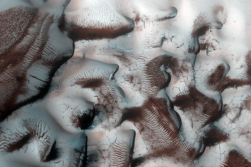
Changing Frost Patterns in Louth Crater (MRO/HiRISE) - imaged 26 Mar 2008
This image shows the changing seasonal frost patterns on Louth Crater, located at latitude 70 N. This crater contains a mound covered by water frost that persists throughout the year, which is unusual for this latitude.
The seasonal carbon dioxide frost deposited during northern winter can also reach this latitude. At the time this image was acquired in northern spring, the carbon dioxide frost is in the process of sublimating back into the atmosphere.
There are sand dunes near the edge of the mound, which become clear of frost in the summer
[color=darkred]Let's go to Mars and far beyond - triple NASA's budget ![/color] [url=irc://freenode#space] #space channel !! [/url] [url=http://www.youtube.com/user/c1cl0ps] - videos !!![/url]
Offline
Like button can go here
#206 2008-05-09 09:40:21
- Vincent
- Banned
- From: North Carolina USA
- Registered: 2008-04-13
- Posts: 623
Re: Real images of Mars
Defrosting dunes from NASA. You are going to give me a nervous breakdown cIclops.
How about a rough image from ESA, etiology still under debate.
I call it the green green grass of home. Mineralogy?
Vincent
Argument expected.
I don't require agreement when presenting new ideas.
-Dana Johnson
Offline
Like button can go here
#207 2008-05-12 02:26:57
- cIclops
- Member
- Registered: 2005-06-16
- Posts: 3,230
Re: Real images of Mars
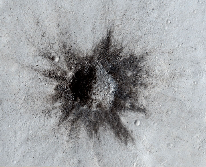
Rayed Crater in Tharsis Region (MRO/HiRISE) - imaged 11 Apr 2008
This image shows a small rayed impact crater, about 160 meters (530 feet) in diameter, in the Tharsis region in the northern hemisphere of Mars.
Relatively recent impacts form rays of ejecta that spray out radially from the crater. In addition to relatively fine material, large boulders and smaller secondary craters are visible in the rays surrounding this crater.
Secondary craters are recognized by their shallow depths (in comparison to primary craters), irregular shapes, and appearance in clusters and linear chains.
[color=darkred]Let's go to Mars and far beyond - triple NASA's budget ![/color] [url=irc://freenode#space] #space channel !! [/url] [url=http://www.youtube.com/user/c1cl0ps] - videos !!![/url]
Offline
Like button can go here
#208 2008-05-12 09:38:46
- Vincent
- Banned
- From: North Carolina USA
- Registered: 2008-04-13
- Posts: 623
Re: Real images of Mars
Secondary craters are recognized by their shallow depths (in comparison to primary craters), irregular shapes, and appearance in clusters and linear chains.
Now this is pure speculation with total disregard to the sub-surface environment. Atmospheric break-up could result in clusters or chains but heat induced collapse from phase change could produce the same image in a frozen Mars tundra.
Vincent
Argument expected.
I don't require agreement when presenting new ideas.
-Dana Johnson
Offline
Like button can go here
#209 2008-05-12 09:54:57
- Vincent
- Banned
- From: North Carolina USA
- Registered: 2008-04-13
- Posts: 623
Re: Real images of Mars
Real images?
You can not have a 95% CO2 atmosphere coming in to contact with a -125 atmospheric condition without some condensation. This from an old weatherman
A true image from HST.
Vincent

Argument expected.
I don't require agreement when presenting new ideas.
-Dana Johnson
Offline
Like button can go here
#210 2008-05-12 10:17:08
- cIclops
- Member
- Registered: 2005-06-16
- Posts: 3,230
Re: Real images of Mars
Atmospheric break-up could result in clusters or chains ...
Breakup of a meteor in the atmosphere would be most unlikely to result in a linear chain, especially in an atmosphere as thin as Mars. Tidal disruption of the body before entering the atmosphere seems the most likely cause of similar size chain craters. Secondary craters are usually sorted in decreasing size and point back to the original impact crater.
[color=darkred]Let's go to Mars and far beyond - triple NASA's budget ![/color] [url=irc://freenode#space] #space channel !! [/url] [url=http://www.youtube.com/user/c1cl0ps] - videos !!![/url]
Offline
Like button can go here
#211 2008-05-12 11:17:15
- Vincent
- Banned
- From: North Carolina USA
- Registered: 2008-04-13
- Posts: 623
Re: Real images of Mars
Breakup of a meteor in the atmosphere would be most unlikely to result in a linear chain
Not a chance brother. Unless you have a sub-terrain profile
This is good stuff.
Vincent
Argument expected.
I don't require agreement when presenting new ideas.
-Dana Johnson
Offline
Like button can go here
#212 2008-05-14 07:54:41
- Vincent
- Banned
- From: North Carolina USA
- Registered: 2008-04-13
- Posts: 623
Re: Real images of Mars
cIclops,
Without a subterranean understanding of Mars the rationale for chains is up in the air. If you see Mars as a frozen dust covered ice ball like me then you see collapse features.
Break up of the comet impact on Jupiter occurred before atmospheric interaction and was gravitationally induced. Post atmospheric entry would require a thicker atmosphere in my opinion and result in plasma reconciliation before impact.
Volatile phase change and collapse would be a more viable explanation.
Vincent
http://www.lpi.usra.edu/meetings/lpsc2000/pdf/1332.pdf

Argument expected.
I don't require agreement when presenting new ideas.
-Dana Johnson
Offline
Like button can go here
#213 2008-05-16 10:02:55
- Vincent
- Banned
- From: North Carolina USA
- Registered: 2008-04-13
- Posts: 623
Re: Real images of Mars
It seemed like the right thing to do.
Vincent

Argument expected.
I don't require agreement when presenting new ideas.
-Dana Johnson
Offline
Like button can go here
#214 2008-05-19 11:19:02
- Vincent
- Banned
- From: North Carolina USA
- Registered: 2008-04-13
- Posts: 623
Re: Real images of Mars
Without water, we can not have a rainbow.
Sol 101 from Opportunity
Vincent

Argument expected.
I don't require agreement when presenting new ideas.
-Dana Johnson
Offline
Like button can go here
#215 2008-05-19 12:17:49
- cIclops
- Member
- Registered: 2005-06-16
- Posts: 3,230
Re: Real images of Mars
That's a new one, got a link?
[color=darkred]Let's go to Mars and far beyond - triple NASA's budget ![/color] [url=irc://freenode#space] #space channel !! [/url] [url=http://www.youtube.com/user/c1cl0ps] - videos !!![/url]
Offline
Like button can go here
#216 2008-05-21 08:55:30
- Vincent
- Banned
- From: North Carolina USA
- Registered: 2008-04-13
- Posts: 623
Re: Real images of Mars
No link on the above image, just some basic knowledge.
Next Image, possible lake?
Vincent

Argument expected.
I don't require agreement when presenting new ideas.
-Dana Johnson
Offline
Like button can go here
#217 2008-05-24 15:04:54
- Vincent
- Banned
- From: North Carolina USA
- Registered: 2008-04-13
- Posts: 623
Re: Real images of Mars
Possible smoke or steam at 41.53 south. MOC image with no thermal, IR or UV data and no follow up with MRO.
Raw image 1
Analysis image 2
Earth comparison image 3
Vincent
1

2 
3

Argument expected.
I don't require agreement when presenting new ideas.
-Dana Johnson
Offline
Like button can go here
#218 2008-05-24 16:47:55
- PeterC
- Banned
- From: France
- Registered: 2008-05-10
- Posts: 4
Re: Real images of Mars
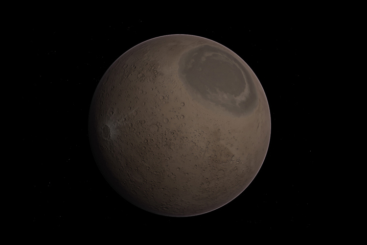
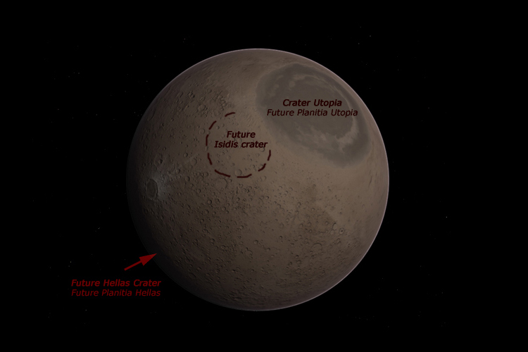
I created a texture of the ancient surface of Mars in the Noachian era. Here's the first image.
Its are the planet Mars there is dated -4.100 billion years. The surface, even the northern hemisphere, is entirely very craters. In this image bellow, the crater is grayish the young giant crater Utopia (future Utopia Planitia), which was created by the large meteorite or well the planetesimals.
In that time, the planet is not actual red and there is probably similar to Earth just at the end of planetary formation. The ocean liquid training has not yet published, it will have in a hundred or a few tens of millions of years due to the atmosphere more dense future. The volcanoes and volcanic domes are not present either, as well as craters Hellas, Isidis and Argyre, nor polar ice caps. The planet Mars is flat all.
Offline
Like button can go here
#219 2008-05-24 17:24:25
- Vincent
- Banned
- From: North Carolina USA
- Registered: 2008-04-13
- Posts: 623
Re: Real images of Mars
A thinker. That’s a good thing
I do not have the knowledge to speculate, Maybe you do.
I will call the Geo types out for you
PS, If they call you nutty do not sweat it brother. If they supply science then try to apply it and learn.
Vincent
Argument expected.
I don't require agreement when presenting new ideas.
-Dana Johnson
Offline
Like button can go here
#220 2008-05-26 03:46:25
- cIclops
- Member
- Registered: 2005-06-16
- Posts: 3,230
Re: Real images of Mars

Polygonal patterns, Vastitas Borealis (PHX/SSI) - imaged 26 May 2008
Icy, Patterned Ground on Mars - 26 May 2008
This image shows a polygonal pattern in the ground near NASA's Phoenix Mars Lander, similar in appearance to icy ground in the arctic regions of Earth.
Phoenix touched down on the Red Planet at 4:53 p.m. Pacific Time (7:53 p.m. Eastern Time), May 25, 2008, in an arctic region called Vastitas Borealis, at 68 degrees north latitude, 234 degrees east longitude.
This is an approximate-color image taken shortly after landing by the spacecraft's Surface Stereo Imager, inferred from two color filters, a violet, 450-nanometer filter and an infrared, 750-nanometer filter.
[color=darkred]Let's go to Mars and far beyond - triple NASA's budget ![/color] [url=irc://freenode#space] #space channel !! [/url] [url=http://www.youtube.com/user/c1cl0ps] - videos !!![/url]
Offline
Like button can go here
#221 2008-05-26 05:06:26
- Vincent
- Banned
- From: North Carolina USA
- Registered: 2008-04-13
- Posts: 623
Re: Real images of Mars
Colorized horizon in Hortacolor, sharp man, real sharp.
Vincent

Argument expected.
I don't require agreement when presenting new ideas.
-Dana Johnson
Offline
Like button can go here
#222 2008-05-27 03:06:29
- Vincent
- Banned
- From: North Carolina USA
- Registered: 2008-04-13
- Posts: 623
Re: Real images of Mars
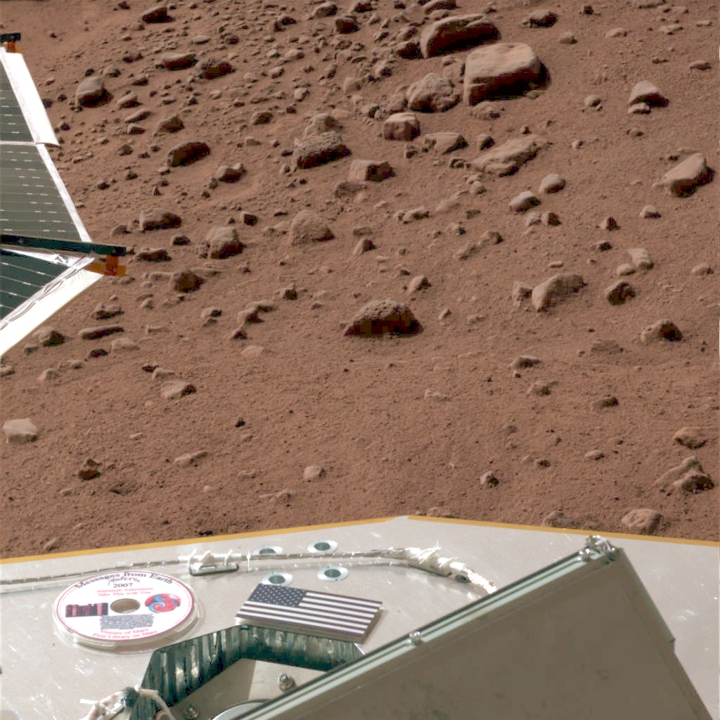
Message disk, I am on it!
Vincent
Argument expected.
I don't require agreement when presenting new ideas.
-Dana Johnson
Offline
Like button can go here
#223 2008-05-27 06:22:41
- cIclops
- Member
- Registered: 2005-06-16
- Posts: 3,230
Re: Real images of Mars
Me too ![]()
(note that the two previous images are from the Phoenix Lander SSI camera imaged 26 May 2008)
[color=darkred]Let's go to Mars and far beyond - triple NASA's budget ![/color] [url=irc://freenode#space] #space channel !! [/url] [url=http://www.youtube.com/user/c1cl0ps] - videos !!![/url]
Offline
Like button can go here
#224 2012-11-13 15:41:12
- falkor
- Member
- From: Surrey
- Registered: 2004-08-21
- Posts: 112
Re: Real images of Mars
there are some pretty interesting images on this page, shame about the flickr busts but the one with the comment "Next Image, possible lake?" from Vincent intrigues me
Vincent after 4 years (since posted) anymore thoughts on that "Lake"?
also Vincent can we have some words on the photo above please ![]()
Offline
Like button can go here
#225 2013-07-18 11:27:36
- Vincent
- Banned
- From: North Carolina USA
- Registered: 2008-04-13
- Posts: 623
Re: Real images of Mars
The "lake" image is representative. The question is only, How old? The lost likely source is ground water and or melt water. Melt water is most likely, from impact heat. The ESA did publish a south polar image that shows a history of floods post impact.
I will post it if I can find it before I drift off.....
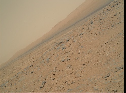
This image was taken in the last few sol's by the hand imager. It is a "raw or natural color" image previously called "true color." A characteristic of natural color is, well, it looks natural... It does not negate the Viking images that were taken in a less atmospheric dusty mid latitude. This site is closer to the southern highlands, the primary source of erosional dust on Mars. I love it when things make sense....
Vincent
0333MH0305000000C0_DXXX by dfrank39, on Flickr
Argument expected.
I don't require agreement when presenting new ideas.
-Dana Johnson
Offline
Like button can go here
