You are not logged in.
- Topics: Active | Unanswered
Announcement
#101 2007-12-19 03:42:06
- cIclops
- Member
- Registered: 2005-06-16
- Posts: 3,230
Re: Real images of Mars
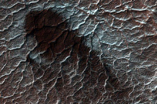
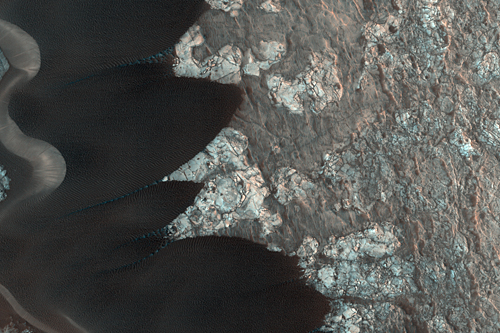
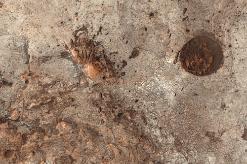
South pole translucent carbon dioxide ice (MRO/HiRISE) - imaged 13 Mar 2007
In a region near the south pole of Mars translucent carbon dioxide ice covers the ground seasonally. For the first time we can "see" the translucent ice by the effect it has on the appearance of the surface below.
Dark fans of dust from the surface drape over the top of the seasonal ice. The surface would be the same color as the dust except that the seasonal ice affecting its appearance. Bright bluish streaks are frost that has re-crystallized from the atmosphere.
Sunlight can penetrate through the seasonal layer of translucent ice to warm the ground below. That causes the seasonal ice layer to sublime (evaporate) from the bottom rather than the top.
[color=darkred]Let's go to Mars and far beyond - triple NASA's budget ![/color] [url=irc://freenode#space] #space channel !! [/url] [url=http://www.youtube.com/user/c1cl0ps] - videos !!![/url]
Offline
Like button can go here
#102 2007-12-23 07:39:31
- cIclops
- Member
- Registered: 2005-06-16
- Posts: 3,230
Re: Real images of Mars
Chryse Planitia Surfaces (MRO/HiRISE false color) - imaged 27 Nov 2007
This image shows part of the surface of Chryse Planitia, near the mouth of several of the giant outflow channels carved by massive floods. At this location the channel is much too large to be seen within a HiRISE image, and this shows an area of level plains near the mouth.
Two geologic units are visible at this site: a relatively dark expanse in the southern part of the image, and a light, slightly higher-standing area along the northern edge. The light unit may be material that has flowed out from below the surface in a process called mud volcanism. However, many aspects of the history of the northern plains of Mars remain uncertain.
A few other prominent features are present. A long trough with aeolian (wind-blown) ripples runs through the eastern part of the image. This feature likely formed by contraction of the surface layer. This must have occurred after the formation of the light material since it cuts through the light unit in the northwest part of the image. There is also a large mound which appears to bury part of the trough, and thus is even younger. Alternatively, two troughs could both terminate at the hill.
Despite the resolution of HiRISE, the nature of this mound is still unclear. It has a rugged surface, which might mean that it has been eroded enough to remove indications of its origin.
[color=darkred]Let's go to Mars and far beyond - triple NASA's budget ![/color] [url=irc://freenode#space] #space channel !! [/url] [url=http://www.youtube.com/user/c1cl0ps] - videos !!![/url]
Offline
Like button can go here
#103 2007-12-30 18:15:32
- cIclops
- Member
- Registered: 2005-06-16
- Posts: 3,230
Re: Real images of Mars

Cape St. Mary, Victoria Crater (MER Opportunity/Pancam super-resolution) - imaged 23 Jun 2007
Details and higher resolution images
Another of the best examples of spectacular cross-bedding in Victoria crater are the outcrops at Cape St. Mary, which is an approximately 15 m (45 foot) high promontory located along the western rim of Victoria crater and near the beginning of the rover's traverse around the rim. Like the Cape St. Vincent images, these Pancam super-resolution images have allowed scientists to discern that the rocks at Victoria Crater once represented a large dune field that migrated across this region.
This is a Mars Exploration Rover Opportunity Panoramic Camera image mosaic acquired on sol 1213 (June 23, 2007), and was constructed from a mathematical combination of 32 different blue filter (480 nm) images.
[color=darkred]Let's go to Mars and far beyond - triple NASA's budget ![/color] [url=irc://freenode#space] #space channel !! [/url] [url=http://www.youtube.com/user/c1cl0ps] - videos !!![/url]
Offline
Like button can go here
#104 2008-01-01 06:11:49
- cIclops
- Member
- Registered: 2005-06-16
- Posts: 3,230
Re: Real images of Mars

Closest Approach 2007
Detail & higher resolution images
NASA's Hubble Space Telescope took this close-up of the red planet Mars when it was just 55 million miles – 88 million kilometers – away. This color image was assembled from a series of exposures taken within 36 hours of the Mars closest approach with Hubble's Wide Field and Planetary Camera 2. Mars will be closest to Earth on December 18, at 11:45 p.m. Universal Time (6:45 p.m. EST).
Mars and Earth have a "close encounter" about every 26 months. These periodic encounters are due to the differences in the two planets' orbits. Earth goes around the Sun twice as fast as Mars, lapping the Red Planet about every two years. Both planets have elliptical orbits, so their close encounters are not always at the same distance. In its close encounter with Earth in 2003, for example, Mars was about 20 million miles closer than it is in the 2007 closest approach, resulting in a much larger image of Mars as viewed from Earth in 2003.
The two dominant dark swatches seen just south of the equator on this part of the planet are well observed regions that were originally labeled by early Mars observers. The large triangular shape to the right is Syrtis Major. The horizontal lane to the left is Sinus Meridani. One of NASA's Mars Exploration Rovers, named "Opportunity," landed at the western end of this region in January 2004. At the intersection of these two features is the prominent Huygens crater with a diameter of 270 miles (450 kilometers). South of Huygens is the Hellas impact basin, with a diameter of 1,100 miles (1,760 km) and a depth of nearly 5 miles (8 km). Hellas was formed billions of years ago when an asteroid collided into the Mars surface.
The planet appears free of any dust storms during this closest approach, however, there are significant clouds visible in both the northern and southern polar cap regions. The resolution is 13 miles (21 kilometers) per pixel.
Happy New Year!
[color=darkred]Let's go to Mars and far beyond - triple NASA's budget ![/color] [url=irc://freenode#space] #space channel !! [/url] [url=http://www.youtube.com/user/c1cl0ps] - videos !!![/url]
Offline
Like button can go here
#105 2008-01-05 18:33:24
- cIclops
- Member
- Registered: 2005-06-16
- Posts: 3,230
Re: Real images of Mars
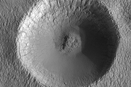
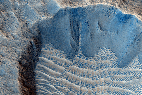
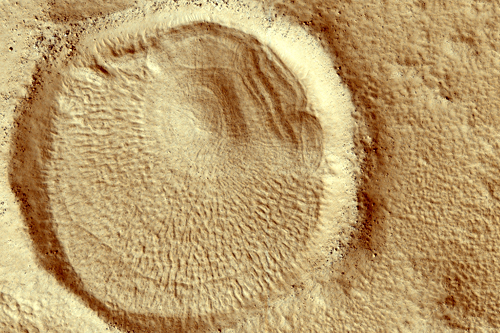
Impact Crater on the South Polar Layered Deposits (MRO/HiRISE) - imaged 20 Sep 2007
This image covers a portion of the ice-rich south polar layered deposits. Layers in the Mars polar regions are of great interest because layers in ice on the Earth, as in the Antarctic and Greenland ice caps, are known to contain records of past atmospheric, environmental, and climate conditions. By studying Mars polar layers, we hope to be able to understand the past climate and history of water on the red planet.
Of particular interest is the small, approximately 330 meter (360 yard) diameter impact crater. The number of impact craters on a planetary surface is often used to estimate the age of that surface (because the older a surface is, the more time that surface has had to accumulate craters, and thus the more craters that surface will have on it, assuming a constant cratering rate). The polar layered deposits on Mars are believed to be very young because there are no large craters on them and very few small craters. The high resolution of HiRISE will enable these craters to be studied in detail, perhaps allowing the number of craters—and thus the surface age—to be better constrained.
[color=darkred]Let's go to Mars and far beyond - triple NASA's budget ![/color] [url=irc://freenode#space] #space channel !! [/url] [url=http://www.youtube.com/user/c1cl0ps] - videos !!![/url]
Offline
Like button can go here
#106 2008-01-07 04:54:45
- cIclops
- Member
- Registered: 2005-06-16
- Posts: 3,230
Re: Real images of Mars
Contact between the Medusae Fossae Formation and Amazonis Planitia (MRO/HiRISE) - imaged 26 Nov 2007
Amazonis Planitia (seen in the northern half of this image) is one of the very flattest places on Mars. It is covered by vast floods of lava that have left a smooth lava plain.
The Medusae Fossae formation (seen in the southern half of this image) is a series of young wind-eroded deposits whose origin continues to be debated. It is generally thought to be composed of volcanic ash, perhaps like pumice on Earth. However, some scientists hypothesize that it is an equatorial ice-rich deposit.
In this image, it can be clearly seen that the Medusae Fossae formation is being eroded off of the Amazonis lavas. Pristine lava features can be seen emerging on either side of the ridges of wind eroding material. The thin wiggly ridges on the lava plains are “pressure ridges” formed by bucking of the lava crust while it flowed. The small cones, a few hundred meters or yards in diameter, that dot the lava plains formed when water underneath the lava turned to steam and exploded through the lava flow.
Today, these cones are still partly filled with Medusae Fossae formation materials. At least in this location, HiRISE finds no evidence for ice at or near the surface of the Medusae Fossae formation. Instead, the wind carved slopes are covered with dark streaks that formed as dry avalanches of dust.
[color=darkred]Let's go to Mars and far beyond - triple NASA's budget ![/color] [url=irc://freenode#space] #space channel !! [/url] [url=http://www.youtube.com/user/c1cl0ps] - videos !!![/url]
Offline
Like button can go here
#107 2008-01-09 04:08:51
- cIclops
- Member
- Registered: 2005-06-16
- Posts: 3,230
Re: Real images of Mars

On Home Plate, Gusev Crater (MER Spirit/Pancam - false color) - imaged end of 2007
Details & higher resolution images
This panorama covers a scene spanning left to right from southwest to northeast. The western edge of Home Plate is in the foreground, generally lighter in tone than the more distant parts of the scene. A rock-dotted hill in the middle distance across the left third of the image is "Tsiolkovski Ridge," about 30 meters or 100 feet from the edge of Home Plate and about that same distance across. A bump on the horizon above the left edge of Tsiolkovski Ridge is "Grissom Hill," about 8 kilometers or 5 miles away. At right, the highest point of the horizon is "Husband Hill," to the north and about 800 meters or half a mile away.
Spirit was perched near the western edge of Home Plate when it used its panoramic camera (Pancam) to take the images used in this view. This view combines separate images taken through Pancam filters centered on wavelengths of 753 nanometers, 535 nanometers and 432 nanometers and is presented in a false-color stretch to bring out subtle color differences in the scene.
[color=darkred]Let's go to Mars and far beyond - triple NASA's budget ![/color] [url=irc://freenode#space] #space channel !! [/url] [url=http://www.youtube.com/user/c1cl0ps] - videos !!![/url]
Offline
Like button can go here
#108 2008-01-10 06:06:22
- cIclops
- Member
- Registered: 2005-06-16
- Posts: 3,230
Re: Real images of Mars
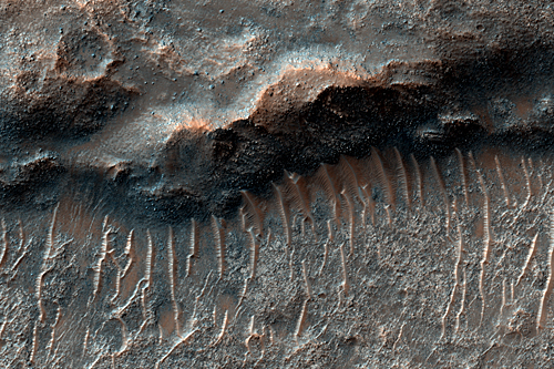
Wrinkle Ridge in Solis Planum (MRO/HiRISE false color) - imaged 15 Dec 2007
Higher resolution images and text
This observation shows a wrinkle ridge in the Solis Planum, a region of Mars that is a high-elevation volcanic plain located south of the Valles Marineris canyon system and east of the Tharsis volcanic complex. In the Solis Planum, wrinkle ridges are typically spaced apart roughly 40 kilometers (25 miles).
Wrinkle ridges are linear to arcuate positive relief features and are often characterized by a broad arch topped with a crenulated ridge. These features have been identified on many bodies such as the Moon, Mercury, and Venus. On Mars, they are many tens-to- hundreds of kilometers long, tens of kilometers wide, and have a relief of a few hundred meters. Wrinkle ridges are most commonly believed to form from horizontal compression or shortening of the crust due to faulting and are often found in volcanic plains.
Wrinkle ridges commonly have asymmetrical cross sectional profiles and an offset in elevation on either side of the ridge. The ridge in this image (see subimage) appears to have a steeper southeast facing slope and a more gentle northwest facing slope. Some layering is also apparent in the ridge. Large dunes border the ridge to the north.
The reddish colors visible in the color image most likely indicate the presence of dust (or indurated dust).
[color=darkred]Let's go to Mars and far beyond - triple NASA's budget ![/color] [url=irc://freenode#space] #space channel !! [/url] [url=http://www.youtube.com/user/c1cl0ps] - videos !!![/url]
Offline
Like button can go here
#109 2008-01-15 08:33:27
- cIclops
- Member
- Registered: 2005-06-16
- Posts: 3,230
Re: Real images of Mars

Near the edge of Victoria Crater (MER Opportunit/Pancam) - imaged 1 May 2007
This view from Opportunity shows the tracks left by a drive executed with more onboard autonomy than has been used on any other drive by a Mars rover.
Opportunity made the curving, 15.8-meter (52-foot) drive during its 1,160th Martian day, or sol (April 29, 2007). It was testing a navigational capability called "Field D-star," which enables the rover to plan optimal long-range drives around any obstacles in order to travel the most direct safe route to the drive's designated destination. Opportunity and its twin, Spirit, did not have this capability until the third year after their January 2004 landings on Mars. Earlier, they could recognize hazards when they approached them closely, then back away and try another angle, but could not always find a safe route away from hazards. Field D-Star and several other upgrades were part of new onboard software uploaded from Earth in 2006. The Sol 1,160 drive by Opportunity was a Martian field test of Field D-Star and also used several other features of autonomy, including visual odometry to track the rover's actual position after each segment of the drive, avoidance of designated keep-out zones, and combining information from two sets of stereo images to consider a wide swath of terrain in analyzing the route.
Two days later, on Sol 1,162, (May 1, 2007), Opportunity was still at the location it reached during that drive, and the rover's panoramic camera (Pancam) took the exposures combined into this image.
Victoria Crater is in the background, at the top of the image. The Sol 1,160 drive began at the place near the center of the image where tracks overlap each other. Tracks farther away were left by earlier drives nearer to the northern rim of the crater. For scale, the distance between the parallel tracks left by the rover's wheels is about 1 meter (39 inches) from the middle of one track to the middle of the other. The rocks in the center foreground are roughly 7 to 10 centimeters (3 to 4 inches) tall. The rover could actually drive over them easily, but for this test, Settings in the onboard hazard-detection software were adjusted to make these smaller rocks be considered dangerous to the rover. The patch of larger rocks to the right was set as a keep-out zone. The location from which this image was taken is where the rover stopped driving to communicate with Earth. A straight line from the starting point to the destination would be 11 meters (36 feet). Opportunity plotted and followed a smoothly curved, efficient path around the rocks, always keeping the rover in safe areas.
This view combines separate images taken through the Pancam filters centered on wavelengths of 753 nanometers, 535 nanometers and 432 nanometers to produce an approximately true-color panorama.
[color=darkred]Let's go to Mars and far beyond - triple NASA's budget ![/color] [url=irc://freenode#space] #space channel !! [/url] [url=http://www.youtube.com/user/c1cl0ps] - videos !!![/url]
Offline
Like button can go here
#110 2008-01-18 08:00:22
- cIclops
- Member
- Registered: 2005-06-16
- Posts: 3,230
Re: Real images of Mars
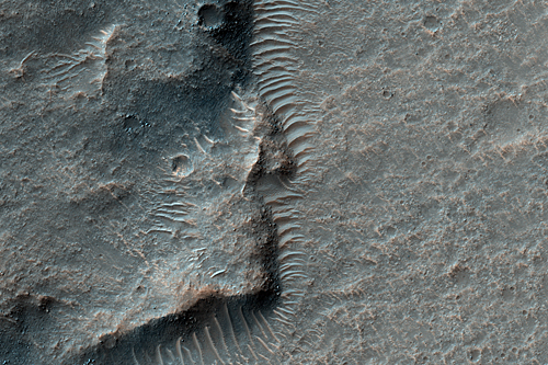
Intra-Crater Deposits in Nilosyrtis (MRO/HiRISE) - imaged 26 Nov 2007
Higher resolution images, subimages & details
Both ancient and modern deposits within craters in the northern lowlands area of Nilosyrtis are visible in this HiRISE observation. This crater and its neighbors are partially filled with sediments that display unusual morphologies, having patterned interiors and radial filaments.
The crater centers are occupied by heavily eroded mounds of material that probably once buried the craters in this region. Horizontal layering is visible in similar mounds elsewhere in this image, and close inspection shows that these mounds are covered by rocks, presumably ejecta from distant impacts.
The accumulation of ejecta on their surfaces indicates that the mounds are not recent deposits of dust or sand, but rather are ancient sediments perhaps deposited in a primordial sea. The radial filaments are much more recent deposits, as shown by the lack of ejecta on their surfaces, and are likely made up of dust and sand that is trapped between the older mounds and the crater walls.
[color=darkred]Let's go to Mars and far beyond - triple NASA's budget ![/color] [url=irc://freenode#space] #space channel !! [/url] [url=http://www.youtube.com/user/c1cl0ps] - videos !!![/url]
Offline
Like button can go here
#111 2008-01-22 07:20:21
- cIclops
- Member
- Registered: 2005-06-16
- Posts: 3,230
Re: Real images of Mars
Sand Dunes in Nili Patera Caldera (MRO/HiRISE 25 cm/pixel) - imaged 13 Oct 2007
A set of dark sand dunes within the northeastern edge of a dune field in Nili Patera, a volcanic caldera in the Syrtis Major region of Mars is the focus of this HiRISE observation.
The lighter surface beneath the dunes is an ancient lava flow. The cracks in the flow probably formed when the lava cooled. Many of the cracks are dark and probably contain sand; the dark color of the dunes suggests that the sand is basaltic in composition and therefore originally derived from volcanic rock.
However, whether the sand formed from Nili Patera is not known, as it is possible the dunes have blown in from a more distal location. With two horns on one end and a rounded edge on the other, the dunes have a distinctive shape. The side of the dunes with the horns has a steeper slope — called the slip face — and the rounded side exhibits a more shallow slope. These types of dunes are called “barchans” and, in analogy with similar dunes on Earth, form in areas with limited sand supply.
The horns of the barchans point in the downwind direction, indicating that the predominant surface winds in this region blew from the east-northeast (slightly upper right in the image). Zooming into the image, one can see landslides on many dune slip faces, indicating fairy recent slope failure. Very small ripples are visible on the dunes” surfaces, showing that the winds in this region have not only blown the barchans across the lava plain, but also modified the dunes themselves.
[color=darkred]Let's go to Mars and far beyond - triple NASA's budget ![/color] [url=irc://freenode#space] #space channel !! [/url] [url=http://www.youtube.com/user/c1cl0ps] - videos !!![/url]
Offline
Like button can go here
#112 2008-01-25 16:47:54
- cIclops
- Member
- Registered: 2005-06-16
- Posts: 3,230
Re: Real images of Mars

Dust-Devil Tracks in Southern Schiaparelli Basin (MRO/HiRISE) - imaged 14 Dec 2007
Dust-devils are vortices of wind that form when air rising from a warm surface encounters shear in the above atmosphere. Martian dust devils can attain gargantuan proportions, reaching the size of terrestrial tornadoes with plumes that tower up to 9 kilometers above the surface. Dust-devils play an important role in sustaining the aerosols that make up Mars’ red sky and in cleaning the Martian surface after a dust storm.
This observation shows a region near the Martian equator that is a perfect tablet for the scribblings of dust-devils. This region is made up of dark bedrock that is thinly blanketed by bright dust. Dark tracks form when dust-devils scour the surface, exposing the darker substrate. The tracks tend to cluster together, as dust-devils repeatedly form over terrain that has been previously scoured and is consequently darker and warmer than the surrounding surface.
Once lofted by a dust-devil, the fine dust can be transported great distances before it settles again onto the surface.
[color=darkred]Let's go to Mars and far beyond - triple NASA's budget ![/color] [url=irc://freenode#space] #space channel !! [/url] [url=http://www.youtube.com/user/c1cl0ps] - videos !!![/url]
Offline
Like button can go here
#113 2008-01-28 05:34:43
- cIclops
- Member
- Registered: 2005-06-16
- Posts: 3,230
Re: Real images of Mars

'Lyell' Panorama inside Victoria Crater (MER Opportunity/Pancam approximately true-color)
Stereo and other images and more details
During four months prior to the fourth anniversary of its landing on Mars, NASA's Mars Exploration Rover Opportunity examined rocks inside an alcove called "Duck Bay" in the western portion of Victoria Crater. The main body of the crater appears in the upper right of this panorama, with the far side of the crater lying about 800 meters (half a mile) away. Bracketing that part of the view are two promontories on the crater's rim at either side of Duck Bay. They are "Cape Verde," about 6 meters (20 feet) tall, on the left, and "Cabo Frio," about 15 meters (50 feet) tall, on the right. The rest of the image, other than sky and portions of the rover, is ground within Duck Bay.
Opportunity's targets of study during the last quarter of 2007 were rock layers within a band exposed around the interior of the crater, about 6 meters (20 feet) from the rim. Bright rocks within the band are visible in the foreground of the panorama. The rover science team assigned informal names to three subdivisions of the band: "Steno," "Smith," and "Lyell."
This view combines many images taken by Opportunity's panoramic camera (Pancam) from the 1,332nd through 1,379th Martian days, or sols, of the mission (Oct. 23 to Dec. 11, 2007). Images taken through Pancam filters centered on wavelengths of 753 nanometers, 535 nanometers and 432 nanometers were mixed to produce an approximately true-color panorama. Some visible patterns in dark and light tones are the result of combining frames that were affected by dust on the front sapphire window of the rover's camera.
[color=darkred]Let's go to Mars and far beyond - triple NASA's budget ![/color] [url=irc://freenode#space] #space channel !! [/url] [url=http://www.youtube.com/user/c1cl0ps] - videos !!![/url]
Offline
Like button can go here
#114 2008-01-30 14:01:57
- cIclops
- Member
- Registered: 2005-06-16
- Posts: 3,230
Re: Real images of Mars
Outcrops in the Hellas Montes (MRO/HiRISE) - imaged 29 Dec 2007
Higher resolution images & text
The Hellas Montes are a group of mountains along the western rim of the giant Hellas Basin on Mars.
The Hellas Basin is the largest of the obvious impact craters on the Red Planet. It is very ancient and has been partially filled by sediments. The Hellas Montes are part of the eroded crater rim.
In the central part of this HiRISE image, we can see steep slopes where landslides have exposed a variety of rocks. The jumble of blocks, rather than stacks of layered sediments or lavas, is consistent with impact crater ejecta. On flatter slopes, the ground is covered with a mantling deposit that is generally considered to be ice-rich dust.
In the southern part of the image, a large circular depression—rimmed by a zone with many large boulders—is visible. This is an impact crater with a relatively thin mantling deposit on its rim.
[color=darkred]Let's go to Mars and far beyond - triple NASA's budget ![/color] [url=irc://freenode#space] #space channel !! [/url] [url=http://www.youtube.com/user/c1cl0ps] - videos !!![/url]
Offline
Like button can go here
#115 2008-02-02 10:39:02
- cIclops
- Member
- Registered: 2005-06-16
- Posts: 3,230
Re: Real images of Mars
Potential MSL Landing Site Near Mawrth Vallis (MRO/HiRISE) - imaged 24 Dec 2007
Higher resolution images & details
Mawrth Vallis contains clay minerals that formed by chemical alteration of rocks by water. It is one of the short list of potential sites that the Mars Science Laboratory rover will land at, and the HiRISE team is working to find a safe place to land in this area.
This observation shows a wide variety of scientifically interesting terrains as well as some potential hazards for landing. The central part of the image is dominated by light-toned materials with curving fractures of many different sizes. These fractures do not have a preferred orientation, indicating that they did not form in response to some regional stress pattern.
Instead, they formed by some more uniform process, possibly the drying of a thick mud deposit or the gradual rebound of the area as the overlying material was eroded away. The scattered mounds and sand dunes may or may not prove to be a danger, but it is reassuring to see that many of the impact craters have been smoothed out with a filling of wind-blown sand.
[color=darkred]Let's go to Mars and far beyond - triple NASA's budget ![/color] [url=irc://freenode#space] #space channel !! [/url] [url=http://www.youtube.com/user/c1cl0ps] - videos !!![/url]
Offline
Like button can go here
#116 2008-02-06 03:59:40
- cIclops
- Member
- Registered: 2005-06-16
- Posts: 3,230
Re: Real images of Mars
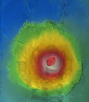
Olympus Mons (MEX/HRSC orthoimage)
ESA presents Mars in 3D - 5 Feb 2008
Mars is about to come into 3D focus as never before, thanks to the data from the Mars Express High Resolution Stereo Camera (HRSC). A new high-resolution Digital Terrain Model data set that has just been released onto the Internet, will allow researchers to obtain new information about the Red Planet in 3D.
Digital Terrain Models (DTMs) allow scientists to ‘stand’ on planetary surfaces. Although ordinary images can give spectacular bird’s-eye views, they can only convey part of the picture. They miss out on the topography, or the vertical elevation of the surroundings. That’s where Mars Express comes in.
The HRSC was especially designed to provide this information and, after years of specialised data processing, the first comprehensive release of 3D data of a large part of the martian surface is now ready. “Understanding the topography of Mars is essential to understanding its geology,” says Prof. Gerhard Neukum, Freie Universität (FU) Berlin, Germany, Principal Investigator for the HRSC.
The DTM can instantly tell researchers the slope of hillsides or the height of cliffs, the altitude and slope of lava flows or desert plains. “This data is essential for understanding how water or lava flowed across Mars,” says Neukum.
[color=darkred]Let's go to Mars and far beyond - triple NASA's budget ![/color] [url=irc://freenode#space] #space channel !! [/url] [url=http://www.youtube.com/user/c1cl0ps] - videos !!![/url]
Offline
Like button can go here
#117 2008-02-10 03:41:47
- cIclops
- Member
- Registered: 2005-06-16
- Posts: 3,230
Re: Real images of Mars
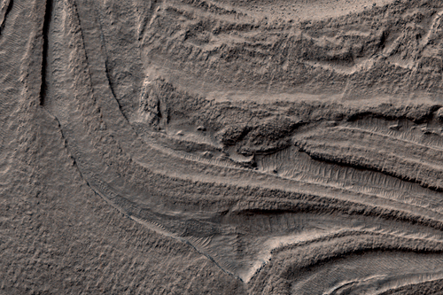
Wrinkle Ridge in Solis Planum (MRO/HiRISE) - imaged 21 Dec 2007
Higher resolution images & more details
This observation shows a wrinkle ridge in Solis Planum, located in the Thaumasia region of Mars, a high-elevation volcanic plain located south of the Valles Marineris canyon system and east of the Tharsis volcanic complex. Solis Planum contains some of the most distinct and well studied arrays of wrinkle ridges on Mars.
Wrinkle ridges are long, winding topographic highs and are often characterized by a broad arch topped with a crenulated ridge. These features have been identified on many other planetary bodies such as the Moon, Mercury, and Venus. On Mars, they are many tens to hundreds of kilometers long, tens of kilometers wide, and have a relief of a few hundred meters. Wrinkle ridges are most commonly believed to form from horizontal compression or shortening of the crust due to faulting and are often located in volcanic plains. They commonly have asymmetrical cross sectional profiles and an offset in elevation on either side of the ridge. Large dunes are also visible bordering the wrinkle ridge.
The reddish colors seen in this image most likely indicate the presence of dust (or indurated dust) and the darker, bluish colors most likely indicate the presence of larger rocks and boulders on the wrinkle ridge.
[color=darkred]Let's go to Mars and far beyond - triple NASA's budget ![/color] [url=irc://freenode#space] #space channel !! [/url] [url=http://www.youtube.com/user/c1cl0ps] - videos !!![/url]
Offline
Like button can go here
#118 2008-02-15 04:55:25
- cIclops
- Member
- Registered: 2005-06-16
- Posts: 3,230
Re: Real images of Mars
Dunes with Unusual Gully (MRO/HiRISE) - imaged 27 Dec 2007
Higher resolution images and more details
Seen here is the eastern edge of a dune field in a large, degraded crater in the southern hemisphere. Similar to other dunes on Mars, these dunes are dark-toned and contain gullies.
Gullies are features found on slopes and dunes in the mid-latitudes of both hemispheres. Both slope and dune gullies were initially suggested to be a result of liquid water from the surface or subsurface. Slope and dune gullies usually have different morphologies: dune gullies are more linear and have levees bordering their channels. They typically have no distinguishable, or very small, alcove and debris aprons. Slope gullies, on the other hand, often have deeply incised alcoves and channels that exhibit fluvial characteristics such as streamlined islands.
What is highly unusual about this dune field is that one of its gullies has the morphology of a slope gully (approximately 3 kilometers across)! This dune gully has a very incised alcove, what appears to be streamlined islands on the channel floor, and a large, feathery debris apron.
[color=darkred]Let's go to Mars and far beyond - triple NASA's budget ![/color] [url=irc://freenode#space] #space channel !! [/url] [url=http://www.youtube.com/user/c1cl0ps] - videos !!![/url]
Offline
Like button can go here
#119 2008-02-18 12:37:13
- cIclops
- Member
- Registered: 2005-06-16
- Posts: 3,230
Re: Real images of Mars
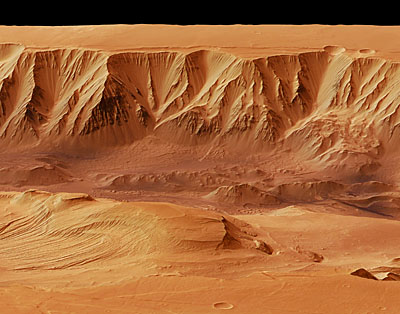
Deep Valleys of Candor Chasma (MEX/HRSC) - imaged 6 Jun 2006
The High Resolution Stereo Camera on the orbiter obtained the data in orbit number 3195, with a ground resolution of approximately 20 m/pixel. Candor Chasma lies at approximately 6° south and 290° east.
Valles Marineris is an approximately 3000-km-long canyon system on Mars. Candor Chasma, situated in its northern part, is part of a radial graben system. A graben is a feature bound by parallel normal faults, where the graben floor moves downward relative to the adjoining material. The grabens in the area were created radially, as the Tharsis bulge formed due to volcanic uplift.
[color=darkred]Let's go to Mars and far beyond - triple NASA's budget ![/color] [url=irc://freenode#space] #space channel !! [/url] [url=http://www.youtube.com/user/c1cl0ps] - videos !!![/url]
Offline
Like button can go here
#120 2008-02-25 04:25:11
- cIclops
- Member
- Registered: 2005-06-16
- Posts: 3,230
Re: Real images of Mars
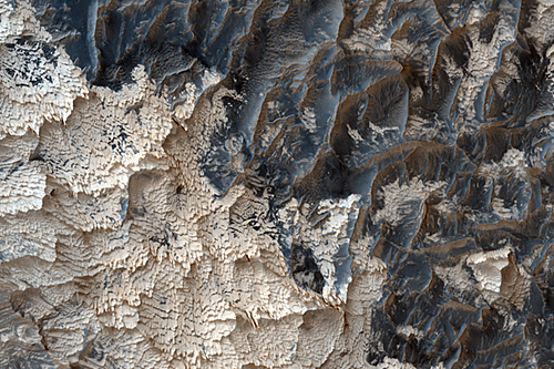
Clays in Mawrth Vallis (MRO/HiRISE) - imaged 3 Jan 2008
Higher resolution images & details
Mawrth Vallis is one of the most colorful parts of Mars. However, it is not quite as colorful as seen in this observation, where this “extra” color comes from the fact that HiRISE can “see” into part of the infrared, enhancing its ability to detect color differences that are indicative of various minerals.
Properly identifying those minerals is where the CRISM instrument excels. They show that this area has a variety of different types of clay minerals: these are especially interesting because they had to form when water was interacting with rocks. The different types of clays point to different water chemistries and temperatures.
With HiRISE, we can better pinpoint how these different materials are distributed across the surface. Furthermore, by taking two images we can produce a stereo image and see the topography, allowing the different clay-bearing layers to be traced in three dimensions.
[color=darkred]Let's go to Mars and far beyond - triple NASA's budget ![/color] [url=irc://freenode#space] #space channel !! [/url] [url=http://www.youtube.com/user/c1cl0ps] - videos !!![/url]
Offline
Like button can go here
#121 2008-02-28 07:34:00
- cIclops
- Member
- Registered: 2005-06-16
- Posts: 3,230
Re: Real images of Mars
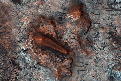
Colorful Outcrops in Schiaparelli (MRO/HiRISE) - imaged 4 Jan 2008
Higher resolution images & text
This image shows several colorful outcrops of rock in Schiaparelli, a large impact crater near Mars' equator. The colors indicate different rock layers and wind-blown materials, and a varied and complex geologic history. The area of the image is now being eroded, exposing several different types of material.
<snip>
Elsewhere in the image, the surface is blue and brown and has a ridged or rippled appearance, with several different scales of ripples. This material appears to sit on top of the light rocks near the center. These ridges have the appearance of ripples formed by wind-blown sand; strangely, however, some appear linked with ridges in the light outcrop at the center, so these could have been lithified (turned to rock). Observations like this one suggest that the relations between the units here are complex, since the units seem linked despite different colors and textures.
[color=darkred]Let's go to Mars and far beyond - triple NASA's budget ![/color] [url=irc://freenode#space] #space channel !! [/url] [url=http://www.youtube.com/user/c1cl0ps] - videos !!![/url]
Offline
Like button can go here
#122 2008-03-03 05:10:07
- cIclops
- Member
- Registered: 2005-06-16
- Posts: 3,230
Re: Real images of Mars
 ....................................................
Aram Chaos outlet details (Odyssey/THEMIS) - imaged 10 Dec 2007
Zoomable image and many more details
The lake that filled Aram must have overflowed at least once because the waters carved an 80-km (50-mi) long channel through the impact basin's eastern rim. The channel averages 15 km (9 mi) wide and 2,500 meters (8,200 feet) deep; it meanders only a little on its course from Aram to Ares Vallis.
The area inside Aram near the outlet shows many grooves (see the THEMIS image at right), which scientists interpret as being cut by the surging floods that thundered out of Aram into the Ares-bound channel.
The warm tint of these sediments in the false-color view indicates a greater amount of hard sediments. This fits a pattern in which lighter and more easily eroded sediments were washed away in the floods.
How much water poured through there at peak is unknown. The water added to the floods that passed through Ares Vallis, but that valley already existed.
Along the walls of the Aram channel, landslides have narrowed the channel's course and dumped debris in its path.
Many layers exposed in the walls of the channel show a long sedimentary history for Aram. Ridges of harder sediments alternate with grooves gouged into more easily eroded layers - this pattern suggests repeating cycles of deposits.
[color=darkred]Let's go to Mars and far beyond - triple NASA's budget ![/color] [url=irc://freenode#space] #space channel !! [/url] [url=http://www.youtube.com/user/c1cl0ps] - videos !!![/url]
Offline
Like button can go here
#123 2008-03-04 06:45:22
- cIclops
- Member
- Registered: 2005-06-16
- Posts: 3,230
Re: Real images of Mars
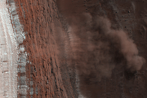
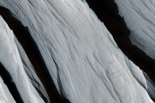
Caught in Action: Avalanches on North Polar Scarps (MRO/HiRISE) - imaged 19 Feb 2008
Material, likely including fine-grained ice and dust and possibly including large blocks, has detached from a towering cliff and cascaded to the gentler slopes below. The occurrence of the avalanches is spectacularly revealed by the accompanying clouds of fine material that continue to settle out of the air. The largest cloud (upper images) traces the path of the debris as it fell down the slope, hit the lower slope, and continues downhill, forming a billowing cloud front. This cloud is about 180 meters (590 feet) across and extends about 190 m (625 ft) from the base of the steep cliff. Shadows to the lower left of each cloud illustrate further that these are three dimensional features hanging in the air in front of the cliff face, and not markings on the ground (sun is from the upper right).
[color=darkred]Let's go to Mars and far beyond - triple NASA's budget ![/color] [url=irc://freenode#space] #space channel !! [/url] [url=http://www.youtube.com/user/c1cl0ps] - videos !!![/url]
Offline
Like button can go here
#124 2008-03-06 08:04:32
- cIclops
- Member
- Registered: 2005-06-16
- Posts: 3,230
Re: Real images of Mars
Complex Folds in Hellas Basin (MRO/HiRISE) - imaged 19 Feb 2008
More details and higher resolution images
Hellas Basin is a large impact basin in the southern hemisphere and contains the lowest topographic point on Mars. This false-color RGB image acquired by HiRISE shows a small portion of the floor of Hellas Basin, revealing complex folded layers.
In some places, these layers appear to have been soft and deformed like taffy, experiencing what is know as “ductile” deformation. In other places, the layers are broken and have long fractures, suggesting they deformed as if they were more solid or experienced what is known as “brittle” deformation. In some areas the rough texture of the surface is caused by the presence of boulders, and the high resolution of HiRISE now makes it possible to study individual boulders and rocks in this region.
The folding of these terrains shows that the geologic history of this region is very complex. Additional images such as these and information about the mineralogy as determined by the CRISM instrument will help scientists to understand how and why these rocks deformed this way.
[color=darkred]Let's go to Mars and far beyond - triple NASA's budget ![/color] [url=irc://freenode#space] #space channel !! [/url] [url=http://www.youtube.com/user/c1cl0ps] - videos !!![/url]
Offline
Like button can go here
#125 2008-03-08 01:55:54
- cIclops
- Member
- Registered: 2005-06-16
- Posts: 3,230
Re: Real images of Mars

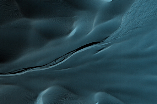
North Polar region (MRO/SHARAD subsurface radargram) - imaged March 2007
INTERNAL STRUCTURE OF THE NORTH POLAR LAYERED DEPOSITS FROM RADAR SOUNDING (PDF) - more images and many more details
[color=darkred]Let's go to Mars and far beyond - triple NASA's budget ![/color] [url=irc://freenode#space] #space channel !! [/url] [url=http://www.youtube.com/user/c1cl0ps] - videos !!![/url]
Offline
Like button can go here