You are not logged in.
- Topics: Active | Unanswered
Announcement
#76 2007-09-28 03:03:30
- cIclops
- Member
- Registered: 2005-06-16
- Posts: 3,230
Re: Real images of Mars
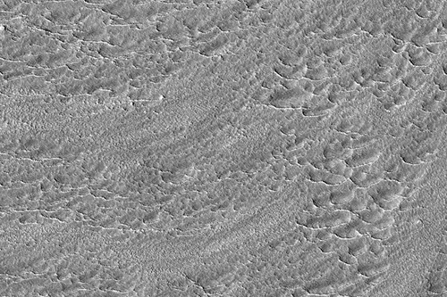
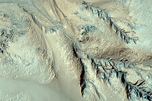
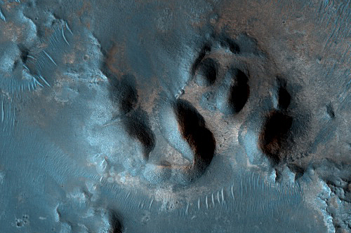
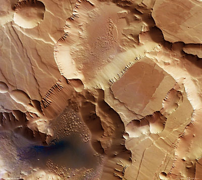
Debris Apron South of Euripus Mons (MRO/HiRISE) - imaged 5 May 2007
Higher resolution images and details
This image was suggested by Andras Sik's SUPERNOVA astronomy and space research class at the Alternative Secondary School of Economics in Budapest, Hungary.
They write: "In the fretted terrains and in the eastern region of the Hellas Basin rim, many plateaus can be found surrounded by a skirt-like debris cover. These debris aprons can extend to 15-25 kilometers long; they have a convex shape, steep front slopes and differ from gravitational talus or fluvial fans. [There may be] ice cores and/or ice cement in the apron material, therefore the closest terrestrial analogs are periglacial rock [terrains]. This HiRISE image shows a small part of Euripus Mons' debris apron [at a] very high resolution so its detailed surface morphology can be investigated and compared to field observations of terrestrial rock glaciers."
Euripus Mons is located to the east of Hellas impact basin in the southern mid-latitudes of Mars.
The overall wavy, curved surface pattern of this debris apron suggests that material flowed out from the isolated flat-top ridge. This mass movement of debris probably involved ice flow (possibly forming rock glaciers) and potentially liquid water.
[color=darkred]Let's go to Mars and far beyond - triple NASA's budget ![/color] [url=irc://freenode#space] #space channel !! [/url] [url=http://www.youtube.com/user/c1cl0ps] - videos !!![/url]
Offline
Like button can go here
#77 2007-10-06 05:13:41
- cIclops
- Member
- Registered: 2005-06-16
- Posts: 3,230
Re: Real images of Mars
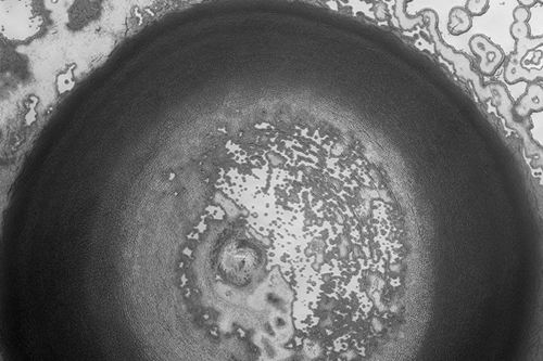
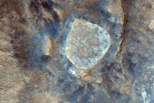
Circular Feature in South Polar Residual Cap (MRO/HiRISE) - imaged 17 Sep 2007
Higher resolution images and details
This 4 kilometer diameter feature near the edge of the south polar residual cap was recognized in Mariner 9 and Viking Orbiter images taken in the 1970s, but its origin could not be inferred. It was therefore targeted for HiRISE stereo imaging.
The bright areas in this image are covered by carbon dioxide frost, and the "swiss cheese" terrain typical of the south polar residual cap covers much of the imaged area. The dark walls of the circular depression do not have as much frost on them, and are fractured in a polygonal pattern. Apparently the surface of the walls has been extensively modified by thermal expansion and contraction of water ice.
It also appears that the "swiss cheese" terrain of the residual cap has buried the floor of the circular depression, as well as the terrain surrounding the feature, making it difficult to infer the origin of this depression. Its circular symmetry is consistent with an impact origin, but there is no evidence of a crater rim or ejecta (perhaps because they have been buried). The depression may have formed by collapse, but there is little evidence of extensional fractures that would be expected around a collapse pit. Analysis of HiRISE stereo data may help the interpretation of this feature.
[color=darkred]Let's go to Mars and far beyond - triple NASA's budget ![/color] [url=irc://freenode#space] #space channel !! [/url] [url=http://www.youtube.com/user/c1cl0ps] - videos !!![/url]
Offline
Like button can go here
#78 2007-10-09 06:40:23
- cIclops
- Member
- Registered: 2005-06-16
- Posts: 3,230
Re: Real images of Mars
Dust Devils Dancing on Dunes (MRO/HiRISE) - imaged 19 Sep 2007
Details and higher resolution images
Dust devils make dark, diffuse scribble markings on the surface by kicking up dust, and are especially active in the summertime over dark surfaces, such as those with many deposits of sand-sized material.
The surface warms up in the sunlight, creating the right conditions to form dust devils. Mars also has larger dust storms that can deposit a thin layer of dust and eliminate the dust devil tracks.
[color=darkred]Let's go to Mars and far beyond - triple NASA's budget ![/color] [url=irc://freenode#space] #space channel !! [/url] [url=http://www.youtube.com/user/c1cl0ps] - videos !!![/url]
Offline
Like button can go here
#79 2007-10-15 06:38:55
- cIclops
- Member
- Registered: 2005-06-16
- Posts: 3,230
Re: Real images of Mars
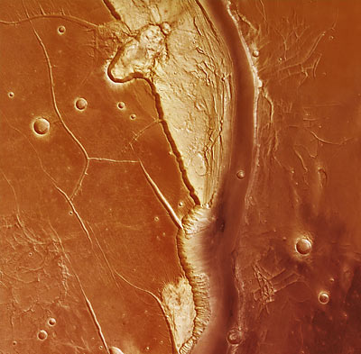
Faults and Folds in Western Candor Chasma (MRO/HiRISE) - false color image 29 Apr 2007
More details and higher resolution images
The rocks along the floor of the chasma consist of multiple layers of light-toned material, possibly windblown or water-lain sediment. These layers have been shifted along faults and also folded, giving the layers an apparent wavy appearance as they are exposed at the surface through erosion.
Some waviness in the layers may also have formed as these sediments were laid down, for example, in dunes or large ripples. Detailed mapping of these faults and folds may help reveal the origin of these layered deposits and if water played any role in their formation.
[color=darkred]Let's go to Mars and far beyond - triple NASA's budget ![/color] [url=irc://freenode#space] #space channel !! [/url] [url=http://www.youtube.com/user/c1cl0ps] - videos !!![/url]
Offline
Like button can go here
#80 2007-10-15 06:43:26
- cIclops
- Member
- Registered: 2005-06-16
- Posts: 3,230
Re: Real images of Mars
Volatiles and Gullies (MRO/HiRISE) - false color image imaged 3 Feb 2007
[color=darkred]Let's go to Mars and far beyond - triple NASA's budget ![/color] [url=irc://freenode#space] #space channel !! [/url] [url=http://www.youtube.com/user/c1cl0ps] - videos !!![/url]
Offline
Like button can go here
#81 2007-10-15 06:46:03
- cIclops
- Member
- Registered: 2005-06-16
- Posts: 3,230
Re: Real images of Mars
West Candor Layering (MRO/HiRISE) - false color image 12 Apr 2007
[color=darkred]Let's go to Mars and far beyond - triple NASA's budget ![/color] [url=irc://freenode#space] #space channel !! [/url] [url=http://www.youtube.com/user/c1cl0ps] - videos !!![/url]
Offline
Like button can go here
#82 2007-10-21 16:42:59
- cIclops
- Member
- Registered: 2005-06-16
- Posts: 3,230
Re: Real images of Mars

Humboldt Peak at Home Plate in Gusev crater (MER Spirit) - imaged 10 Oct 2007
Higher resolution images and text
As it finished its second Martian year on Mars, NASA's Mars Exploration Rover Spirit was beginning to examine a group of angular rocks given informal names corresponding to peaks in the Colorado Rockies. A Martian year -- the amount of time it takes Mars to complete one orbit around the sun -- lasts for 687 Earth days. Spirit completed its second Martian year on the rover's 1,338th Martian day, or sol, corresponding to Oct. 8, 2007.
Two days later, on sol 1,340 (Oct. 10, 2007), Spirit used its front hazard-identification camera to capture this wide-angle view of its robotic arm extended to a rock informally named "Humboldt Peak."
[color=darkred]Let's go to Mars and far beyond - triple NASA's budget ![/color] [url=irc://freenode#space] #space channel !! [/url] [url=http://www.youtube.com/user/c1cl0ps] - videos !!![/url]
Offline
Like button can go here
#83 2007-10-26 15:28:28
- cIclops
- Member
- Registered: 2005-06-16
- Posts: 3,230
Re: Real images of Mars
Low-Order Inverted Streams near Juventae Chasma (MRO/HiRISE) - imaged 17 Sep 2007
Higher resolution images and text
This image shows plains northwest of Juventae Chasma, one of the Martian canyons that are part of the equatorial Valles Marineris system. The two most noticeable features in this scene are craters on mesas (plateaus) and raised, winding ridges.
The raised ridges are inverted channels. It is likely that liquid water, either pure or salt water, flowed through these channels. The channels are raised because streams transport sediment as they flow, deposit the heavier sediment on the stream floor, and, eventually fill in once their water supply dwindles. Over time, wind erosion modifies a landscape, and this has played an important role on these plains. It eroded the land around the channels leaving the remnant channels exposed and standing high. The channels did not erode as much since they were more resistant, possibly because the deposited sediment had cemented together.
The craters on mesas are also evidence of active wind erosion. When craters form, they eject material out onto the surrounding landscape. It appears that several of the craters’ ejecta visible here cemented, making the ejecta more resistant to erosion and leaving them standing high as craters on plateaus.
[color=darkred]Let's go to Mars and far beyond - triple NASA's budget ![/color] [url=irc://freenode#space] #space channel !! [/url] [url=http://www.youtube.com/user/c1cl0ps] - videos !!![/url]
Offline
Like button can go here
#84 2007-10-29 08:28:20
- cIclops
- Member
- Registered: 2005-06-16
- Posts: 3,230
Re: Real images of Mars
Possible Ancient Salt Deposits within Unnamed Crater in Terra Cimmeria (MRO/HiRISE) - imaged 13 Oct 2007
Higher resolution images and details
The ancient cratered highlands of the southern hemisphere of Mars has an intriguing and complex history as it has been riddled with impact craters and modified by volcanic processes and by the wind.
Additionally, it is one of the most heavily dissected terrains on Mars exhibiting the densest population of valley networks: old dried up channels and valleys that may have been formed by surface runoff, the seepage of ground water, or both.
[color=darkred]Let's go to Mars and far beyond - triple NASA's budget ![/color] [url=irc://freenode#space] #space channel !! [/url] [url=http://www.youtube.com/user/c1cl0ps] - videos !!![/url]
Offline
Like button can go here
#85 2007-11-05 02:59:02
- cIclops
- Member
- Registered: 2005-06-16
- Posts: 3,230
Re: Real images of Mars
Nili Fossae Trough (MRO/HiRise false color) - imaged 24 Mar 2007
This is one of the prime MSL candidate landing sites.
The Nili Fossae region of Mars is one of the largest exposures of clay minerals discovered by the OMEGA spectrometer on Mars Express and mapped in greater detail by the CRISM spectrometer on MRO.
In the HiRISE IRB color, dark blue regions are basaltic in composition, including sand-sized material that bounces around in the wind to form dunes. Basalt in the most common type of volcanic rock on the Earth and other terrestrial planets.
The light-toned areas (with a variety of colors) and covered by small-scale fractures is the clay-rich material. Clay minerals contain hydrogen and oxygen (i.e., water) within their mineral structure, and may also preserve organic materials, so there is great interest in studying these deposits to understand past environments that could have supported life.
Scrolling video from south to north over this image - 0:41 mins
[color=darkred]Let's go to Mars and far beyond - triple NASA's budget ![/color] [url=irc://freenode#space] #space channel !! [/url] [url=http://www.youtube.com/user/c1cl0ps] - videos !!![/url]
Offline
Like button can go here
#86 2007-11-09 09:15:32
- cIclops
- Member
- Registered: 2005-06-16
- Posts: 3,230
Re: Real images of Mars
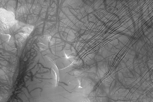
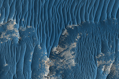
Seasonal Changes of South Polar Dark Dune Field (MRO/HiRISE) - imaged 4 May 2007
Higher resolution images and details
This image was suggested by Andras Sik's SUPERNOVA astronomy and space research class at the Alternative Secondary School of Economics in Budapest, Hungary.
They interpret the image: "During local springtime, a varying albedo pattern can be observed on the surface of dark intracrater dune fields in the southern polar region of Mars. The origin of dark dune spots and the dark slope streaks emanating from them is yet uncertain. There are several possible explanations for these phenomena, like "sublimation of carbon-dioxide frost cover", "dusty carbon-dioxide gas eruptions through the frost cover" and "transient liquid water-formation under layered water-ice/carbon dioxide-ice cover". In this HiRISE image the distribution of dark streaks are not chaotic and their shapes are not fan-like; rather they are composed of confined, dozen-hundred meter long branches which follow the local topography and have accumulation zones at their end."
We are learning a great deal from the enigmatic dark spots that are found throughout the south polar region. These dark spots may have resulted from cold gas jets that form by sublimation of the ice bringing entrained dust to the surface. Small dark streaks may have formed by avalanches of sand or they may be patches of coarse-grained ice that are clear enough so that the dark material below the ice is visible.
The color image also provides helpful clues to understand this process. Bright white frost can be seen covering the surface. This frost is a probably a combination of frozen water and carbon dioxide ice. These bright patches are particularly prevalent along dune slip faces and around dark spots.
[color=darkred]Let's go to Mars and far beyond - triple NASA's budget ![/color] [url=irc://freenode#space] #space channel !! [/url] [url=http://www.youtube.com/user/c1cl0ps] - videos !!![/url]
Offline
Like button can go here
#87 2007-11-10 09:43:36
- cIclops
- Member
- Registered: 2005-06-16
- Posts: 3,230
Re: Real images of Mars

East Face of Cabo Corrientes (MER Opportunity/Pancam) - imaged March 2007 processed by Daniel Crotty
See Daniel's site for more "real" panoramas taken at Victoria crater
[color=darkred]Let's go to Mars and far beyond - triple NASA's budget ![/color] [url=irc://freenode#space] #space channel !! [/url] [url=http://www.youtube.com/user/c1cl0ps] - videos !!![/url]
Offline
Like button can go here
#88 2007-11-13 03:40:25
- cIclops
- Member
- Registered: 2005-06-16
- Posts: 3,230
Re: Real images of Mars
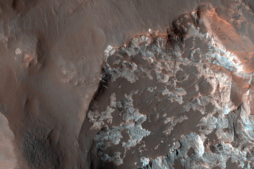
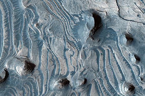
Confluence of Nirgal and Uzboi Valles (MRO/HiRISE) - imaged 1 May 2007
Higher resolution image, sub images and more details
Nirgal and Uzboi Valles are two valleys to the north of the Argyre impact basin in the southern hemisphere. At this location, the smaller channel, Nirgal Vallis, empties out into the larger Uzboi Vallis.
Most of the features in this image are covered by the dust that is ubiquitous on Mars, hiding the original fluvial features. However, a small patch of resistant outcrop can be observed on the southern side of the crater rim. These appear as white patches that are draped by the darker wind-blown rippled sand (see subimage 1). Even the resistant outcrop has been modified by wind, giving it a pockmarked or scalloped texture.
Layering can be seen in the resistant outcrops and in the gullied inner wall of the crater (see subimage 2). These layers may have been fluvial, volcanic, or aeolian (wind-blown). Given their presence within the valley floor, these may represent some of the sedimentary layers deposited by water when it flowed through the valley.
[color=darkred]Let's go to Mars and far beyond - triple NASA's budget ![/color] [url=irc://freenode#space] #space channel !! [/url] [url=http://www.youtube.com/user/c1cl0ps] - videos !!![/url]
Offline
Like button can go here
#89 2007-11-15 16:07:49
- cIclops
- Member
- Registered: 2005-06-16
- Posts: 3,230
Re: Real images of Mars
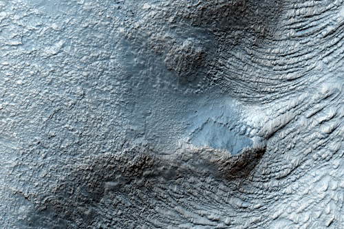
Gullies in the Eastern Hellas Region (MRO/HiRISE) - imaged 15 Oct 2007
Higher resolution images and text
This image shows several gullies along the southern wall of unnamed crater in the eastern Hellas region of Mars. This particular crater has gullies on both the polar and equatorial-facing walls.
The gully floors appear to be filled with rough-textured, somewhat knobby-looking materials. As multiple gullies located upslope feed into a single gully reaching the crater floor, the materials have converged to form a large deposit. Lineations parallel to apparent flow direction are evident on the textured surface.
It's not clear if liquid flows carved the gullies at this location, but the eastern Hellas region is well known for its abundant ice-rich flow features, such as lobate debris aprons at the base of knobs and massifs. Thus, the gully floor materials may have also incorporated ice at some time in the recent past and moved downslope as possible glacial-like flows.
[color=darkred]Let's go to Mars and far beyond - triple NASA's budget ![/color] [url=irc://freenode#space] #space channel !! [/url] [url=http://www.youtube.com/user/c1cl0ps] - videos !!![/url]
Offline
Like button can go here
#90 2007-11-23 02:16:04
- cIclops
- Member
- Registered: 2005-06-16
- Posts: 3,230
Re: Real images of Mars
Spirit at ‘Home Plate’ in Gusev crater (MRO/HiRISE) - imaged 25 Sep 2007
Spirit is visible inside the perimeter of the bright “Home Plate” feature, near the 5:30 position. This color image was created using only the blue-green and red HiRISE channels, so the “B” in this RGB product was synthesized using data from the two available channels.
[color=darkred]Let's go to Mars and far beyond - triple NASA's budget ![/color] [url=irc://freenode#space] #space channel !! [/url] [url=http://www.youtube.com/user/c1cl0ps] - videos !!![/url]
Offline
Like button can go here
#91 2007-11-25 05:49:15
- cIclops
- Member
- Registered: 2005-06-16
- Posts: 3,230
Re: Real images of Mars

Athabasca Valles channel system (MRO/HiRISE) - 3D image (glasses needed)
Details and high resolution image
Dazzled by the beauty of the strange features in the Athabasca Valles channel system on Mars, geologist Windy Jaeger pondered their origin. In a new paper, she concludes that lava filled the channel system to the brim and then drained away leaving a thin coating of hard lava rock to preserve the underlying landscape. Other unique features indicating that massive lava flows once filled the channels are hydrovolcanic cones that formed when water met lava and boiled explosively, leaving behind small, conical and ring-shaped features visible in and around the dune field (upper left).
The high resolution image with 3D glasses is incredible!
[color=darkred]Let's go to Mars and far beyond - triple NASA's budget ![/color] [url=irc://freenode#space] #space channel !! [/url] [url=http://www.youtube.com/user/c1cl0ps] - videos !!![/url]
Offline
Like button can go here
#92 2007-11-27 12:46:47
- cIclops
- Member
- Registered: 2005-06-16
- Posts: 3,230
Re: Real images of Mars
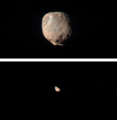
Phobos (top) and Deimos (MRO/CRISM) - imaged in 2007
These two images taken by the Compact Reconnaissance Imaging Spectrometer for Mars (CRISM) show Mars' two small moons, Phobos and Deimos, as seen from the Mars Reconnaisance Orbiter's low orbit around Mars. Both images were taken while the spacecraft was over Mars' night side, with the spacecraft turned off its normal nadir-viewing geometry to glimpse the moons. The image of Phobos, shown at the top, was taken at 0119 UTC on October 23 (9:19 p.m. EDT on Oct. 22), and shows features as small as 400 meters (1320 feet) across. The image of Deimos, shown at the bottom, was taken at 2016 UTC (12:16 p.m. EDT) on Jun. 7, 2007, and shows features as small as 1.3 kilometers (0.8 miles) across. Both of the CRISM images were taken in 544 colors covering 0.36-3.92 micrometers, and are displayed at twice the size in the original data for viewing purposes.
Phobos and Deimos are about 21 and 12 kilometers (13.0 and 7.5 miles) in diameter, and orbit Mars with periods of 7 hours, 39.2 minutes and 1 day, 6 hours, 17.9 minutes respectively.
[color=darkred]Let's go to Mars and far beyond - triple NASA's budget ![/color] [url=irc://freenode#space] #space channel !! [/url] [url=http://www.youtube.com/user/c1cl0ps] - videos !!![/url]
Offline
Like button can go here
#93 2007-11-28 01:57:06
- cIclops
- Member
- Registered: 2005-06-16
- Posts: 3,230
Re: Real images of Mars
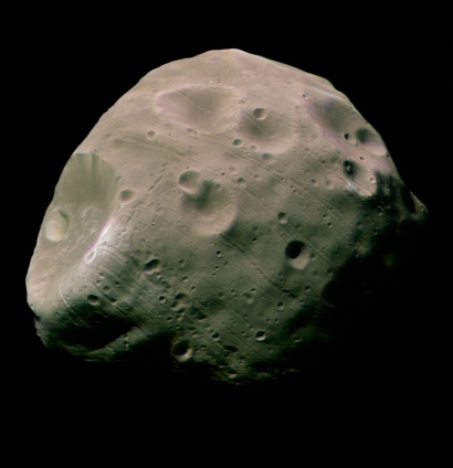
Phobos (MEX/HRSC) - imaged 22 Aug 2004
This image, taken by the High Resolution Stereo Camera (HRSC) on board ESA's Mars Express spacecraft, is one of the highest-resolution pictures so far of the Martian moon Phobos. The colour image was calculated from the three colour channels and the nadir channel on the HRSC.
The image shows the Mars-facing side of the moon, taken from a distance of less than 200 kilometres with a resolution of about seven metres per pixel during orbit 756, on 22 August 2004.
[color=darkred]Let's go to Mars and far beyond - triple NASA's budget ![/color] [url=irc://freenode#space] #space channel !! [/url] [url=http://www.youtube.com/user/c1cl0ps] - videos !!![/url]
Offline
Like button can go here
#94 2007-11-30 01:44:10
- cIclops
- Member
- Registered: 2005-06-16
- Posts: 3,230
Re: Real images of Mars
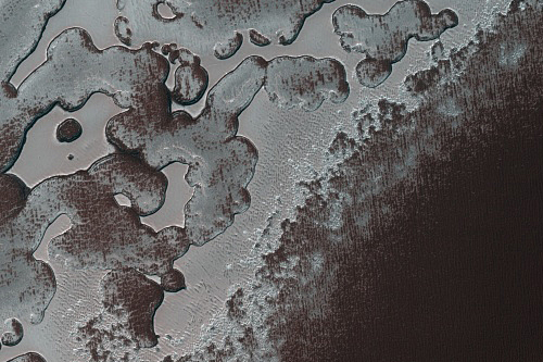
South Polar Residual Cap Margin (MRO/HiRISE in Enhanced Color) - imaged 4 Oct 2007
This scene is about 2.7 kilometers (approximately 1.7 miles) long and shows part of the edge of the south polar residual cap in enhanced color. Illumination is from the lower right.
The relatively bright, grayish areas are the residual cap, and the darker, reddish areas are mostly likely covered by dust. The south polar residual cap is made, for the most part, of carbon dioxide ice (commonly called "dry ice") and dust, with a little water ice in some places.
[color=darkred]Let's go to Mars and far beyond - triple NASA's budget ![/color] [url=irc://freenode#space] #space channel !! [/url] [url=http://www.youtube.com/user/c1cl0ps] - videos !!![/url]
Offline
Like button can go here
#95 2007-12-01 15:07:52
- cIclops
- Member
- Registered: 2005-06-16
- Posts: 3,230
Re: Real images of Mars
Noctis Labyrinthus (MEX/HRSC) - imaged 25 Jun 2006
The HRSC took these pictures on 25 June 2006 in orbit 3155, with a ground resolution of approximately 16 m/pixel.
Noctis Labyrinthus lies at approximately 6.5° south and 260° east. The Sun illuminates the scene from the north-west, top right in the image above.
The region is located directly on the western edge of Valles Marineris, the ‘Grand Canyon’ of Mars. The closely-spaced, deeply incised, smaller, labyrinth-like fractures are eye-catching.
Noctis Labyrinthus forms part of a complex graben-system. This system formed due to extensional tectonics. During the process, intense volcanism in the Tharsis region led to the formation of a bulge, resulting in tectonic stress. This caused the crust to thin out and form graben structures, which are elongated, trench-like features bounded by parallel normal faults
High resolution 3D image (glasses needed)
[color=darkred]Let's go to Mars and far beyond - triple NASA's budget ![/color] [url=irc://freenode#space] #space channel !! [/url] [url=http://www.youtube.com/user/c1cl0ps] - videos !!![/url]
Offline
Like button can go here
#96 2007-12-03 07:09:02
- cIclops
- Member
- Registered: 2005-06-16
- Posts: 3,230
Re: Real images of Mars

Gustev crater Sol 1361 (MER Spirit/Pancam) true color - imaged November 2007
[color=darkred]Let's go to Mars and far beyond - triple NASA's budget ![/color] [url=irc://freenode#space] #space channel !! [/url] [url=http://www.youtube.com/user/c1cl0ps] - videos !!![/url]
Offline
Like button can go here
#97 2007-12-06 08:38:45
- cIclops
- Member
- Registered: 2005-06-16
- Posts: 3,230
Re: Real images of Mars
Northern main channel of Kasei Valles (MEX/HRSC)
Details and higher resolution images
This HRSC image shows the Northern main channel of Kasei Valles, which probably has been formed by gigantic flood events.
The image is centred at 26.97º North latitude and 67.68º West longitude.
[color=darkred]Let's go to Mars and far beyond - triple NASA's budget ![/color] [url=irc://freenode#space] #space channel !! [/url] [url=http://www.youtube.com/user/c1cl0ps] - videos !!![/url]
Offline
Like button can go here
#98 2007-12-09 04:56:32
- cIclops
- Member
- Registered: 2005-06-16
- Posts: 3,230
Re: Real images of Mars

Terra Sirenum (Odyssey/THEMIS false color) - released 27 Aug 2007
Lots of details and zoomable image
On the southwest edge of the immense volcanic region of Tharsis, lava from its giant volcanoes flowed down to meet the old cratered landscape of Terra Sirenum. Scientists can't say how many years separate the flows from the terrain they engulfed, but the relationship between the two tells of a complex tale.
This false-color mosaic image combines separate frames taken by the Thermal Emission Imaging System (THEMIS), a special camera on NASA's Mars Odyssey orbiter. THEMIS photographs Mars in 10 infrared "colors" and five visible ones.
The infrared imaging gives scientists clues about the nature of the surface. THEMIS photographs patches of ground twice per Martian day - once in late afternoon and then again just before night ends - two times when contrasts in surface temperature are strongest.
Under full sunlight, dust, sand, and loose sediments grow warm, even hot, as anybody knows who has walked barefoot across a sunny beach. (Dark materials also do the same.) In the depths of night on Mars, however, fine particles quickly become cold as temperatures plunge after sundown. But rocky areas and ones with expanses of compacted sediments hold onto heat better and glow warmly in THEMIS' infrared vision.
In this false-color mosaic, THEMIS researchers have colored in blues and greens the areas that are cold at night, while nighttime-warm regions appear in reds, oranges, and yellows. The tints distinguish areas covered in dust and sand (cool colors) from exposures of bare rocks and deposits free of fine-grain material (warm colors).
[color=darkred]Let's go to Mars and far beyond - triple NASA's budget ![/color] [url=irc://freenode#space] #space channel !! [/url] [url=http://www.youtube.com/user/c1cl0ps] - videos !!![/url]
Offline
Like button can go here
#99 2007-12-13 04:05:29
- cIclops
- Member
- Registered: 2005-06-16
- Posts: 3,230
Re: Real images of Mars
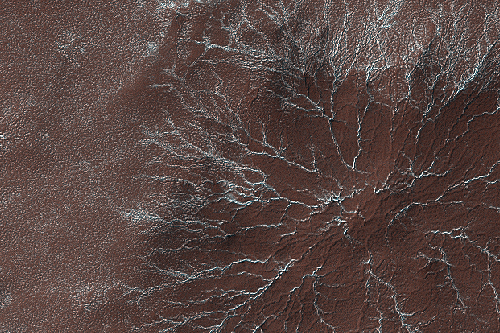
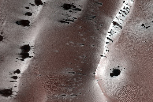
Starburst Channels (MRO/HiRISE) - imaged 12 Apr 2007
Translucent carbon dioxide ice covers the polar regions of Mars seasonally. It is warmed and sublimates (evaporates) from below, and escaping gas carves a numerous channel morphologies.
In this example the channels form a "starburst" pattern, radiating out into feathery extensions. The center of the pattern is being buried with dust and new darker dust fans ring the outer edges. This may be an example of an expanding morphology, where new channels are formed as the older ones fill and are no longer efficiently channeling the subliming gas out.
[color=darkred]Let's go to Mars and far beyond - triple NASA's budget ![/color] [url=irc://freenode#space] #space channel !! [/url] [url=http://www.youtube.com/user/c1cl0ps] - videos !!![/url]
Offline
Like button can go here
#100 2007-12-16 04:24:20
- cIclops
- Member
- Registered: 2005-06-16
- Posts: 3,230
Re: Real images of Mars
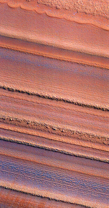
North Layered deposits (MRO/HiRISE false color) - imaged 1 Dec 2006
This false-color image of the north polar layered deposits has been processed to emphasize color variations. It shows that the color as well as texture or morphology varies from layer to layer. Some of the color variations may be caused by small amounts of water frost on the surface, or they may be due to variations in dust composition within the layered deposits. Such changes in composition may have been caused by volcanic eruptions or local weather phenomena when the layers were deposited. Overall, it is thought that the polar layered deposits contain a record of recent climate changes on Mars, similar to ice ages on Earth. High-resolution images like this will be useful in the effort to understand the climate history of Mars.
[color=darkred]Let's go to Mars and far beyond - triple NASA's budget ![/color] [url=irc://freenode#space] #space channel !! [/url] [url=http://www.youtube.com/user/c1cl0ps] - videos !!![/url]
Offline
Like button can go here