You are not logged in.
- Topics: Active | Unanswered
Announcement
#151 2005-09-19 19:28:30
- C M Edwards
- Member
- From: Lake Charles LA USA
- Registered: 2002-04-29
- Posts: 1,012
Re: Earth Atmospherics/Weather
*Oh lord...here comes Rita:
...
rough projections of its track raised the possibility that the Louisiana coast could be targeted less than a month after Hurricane Katrina devastated the area.
...
About half the weather models have my section of the Gulf Coast in the crosshairs now.
I will be retiring to my father-in-law's fishing camp up north this weekend. Rita can come ashore without me.
"We go big, or we don't go." - GCNRevenger
Offline
Like button can go here
#152 2005-09-20 09:36:32
- Palomar
- Member
- From: USA
- Registered: 2002-05-30
- Posts: 9,734
Re: Earth Atmospherics/Weather
*Oh lord...here comes Rita:
...
rough projections of its track raised the possibility that the Louisiana coast could be targeted less than a month after Hurricane Katrina devastated the area.
...
About half the weather models have my section of the Gulf Coast in the crosshairs now.
I will be retiring to my father-in-law's fishing camp up north this weekend. Rita can come ashore without me.
*Best of luck with all that. ![]() Rita is now classed as a Hurricane.
Rita is now classed as a Hurricane.
Also:
From the National Hurricane Center. If all names are used up for this season (hopefully not), we'll be reading about Hurricane Alpha. :?
Each year, 21 common names are reserved for Atlantic Basin hurricanes, with the list arranged alphabetically and skipping certain letters. Rita is the 17th named storm in the Atlantic Basin this year. There are only four left.
So what will officials do after tropical storm Wilma develops, assuming it does?
"We go to the Greek alphabet," said Frank Lepore
I might have known that before, but forgot.
...but is expected to become a Category 3. ::shakes head:: Voluntary evacuations are being called for in Galveston, TX (900 miles from FL Keys). Louisiana Govenor has called for evacuation of the SW portion of LA. Hurricane is already, of course, hitting the Florida Keys.
--Cindy
We all know [i]those[/i] Venusians: Doing their hair in shock waves, smoking electrical coronas, wearing Van Allen belts and resting their tiny elbows on a Geiger counter...
--John Sladek (The New Apocrypha)
Offline
Like button can go here
#153 2005-09-20 11:15:08
- SpaceNut
- Administrator
- From: New Hampshire
- Registered: 2004-07-22
- Posts: 30,758
Re: Earth Atmospherics/Weather
Evacuation of the Keys due to category 3 winds coming if not already there.
Track looks at this point to be headed somewhere between the texas to Louisiana New orleans area.
Huricane Rita's storm track
Offline
Like button can go here
#154 2005-09-20 12:09:59
- Palomar
- Member
- From: USA
- Registered: 2002-05-30
- Posts: 9,734
Re: Earth Atmospherics/Weather
*Uh-oh. ![]()
Rita Strengthens Into Category 2 Hurricane
AP - 34 minutes ago
KEY WEST, Fla. - Rita strengthened rapidly on Tuesday to a Category 2 hurricane as it lashed the Florida Keys with flooding rain and strong wind and sparked fears the storm could eventually bring new misery to the Gulf Coast. Rita went from a tropical storm with top sustained wind of 70 mph early Tuesday to a hurricane with 100 mph wind by early afternoon as it passed just south of the Keys, the National Hurricane Center said. Thousands of residents and tourists had fled the low-lying island chain, where forecasters said Rita could dump up to 8 inches of rain, down from earlier forecasts of up to 15 inches.
Hopefully she'll not strengthen beyond this. Is troubling, though, that she went from Cat 1 to 2 so quickly. This from Yahoo! news.
--Cindy
We all know [i]those[/i] Venusians: Doing their hair in shock waves, smoking electrical coronas, wearing Van Allen belts and resting their tiny elbows on a Geiger counter...
--John Sladek (The New Apocrypha)
Offline
Like button can go here
#155 2005-09-20 13:10:31
- Grypd
- Member
- From: Scotland, Europe
- Registered: 2004-06-07
- Posts: 1,879
Re: Earth Atmospherics/Weather
It is where it gets the energy in this case from the rather hot tempatures of the water and air.
Rita can easily go up to a strength 4 from the power it will gain from the gulf of Mexico.
Chan eil mi aig a bheil ùidh ann an gleidheadh an status quo; Tha mi airson cur às e.
Offline
Like button can go here
#156 2005-09-21 05:32:08
- Palomar
- Member
- From: USA
- Registered: 2002-05-30
- Posts: 9,734
Re: Earth Atmospherics/Weather
*I've read this and another related article (focusing on New Orleans)...N.O. stands a good chance of more flooding. However, the latest tracking map I've seen has Rita heading right for Galveston, TX. A lot of evacuees from N.O. are there and in Houston, of course.
--Cindy
We all know [i]those[/i] Venusians: Doing their hair in shock waves, smoking electrical coronas, wearing Van Allen belts and resting their tiny elbows on a Geiger counter...
--John Sladek (The New Apocrypha)
Offline
Like button can go here
#157 2005-09-21 06:58:25
- Palomar
- Member
- From: USA
- Registered: 2002-05-30
- Posts: 9,734
Re: Earth Atmospherics/Weather
*I've read this and another related article (focusing on New Orleans)...N.O. stands a good chance of more flooding. However, the latest tracking map I've seen has Rita heading right for Galveston, TX. A lot of evacuees from N.O. are there and in Houston, of course.
Less than 2 hours later I've seen a Yahoo! article saying Rita is now classed at Category 4. ![]()
::shakes head::
--Cindy
We all know [i]those[/i] Venusians: Doing their hair in shock waves, smoking electrical coronas, wearing Van Allen belts and resting their tiny elbows on a Geiger counter...
--John Sladek (The New Apocrypha)
Offline
Like button can go here
#158 2005-09-21 15:39:47
- Grypd
- Member
- From: Scotland, Europe
- Registered: 2004-06-07
- Posts: 1,879
Re: Earth Atmospherics/Weather
RITA is now a category 5
And there is plenty of energy to keep her going I just hope she will fade a bit before she crashes to shore ![]()
Chan eil mi aig a bheil ùidh ann an gleidheadh an status quo; Tha mi airson cur às e.
Offline
Like button can go here
#159 2005-09-21 15:44:06
- Palomar
- Member
- From: USA
- Registered: 2002-05-30
- Posts: 9,734
Re: Earth Atmospherics/Weather
RITA is now a category 5
And there is plenty of energy to keep her going I just hope she will fade a bit before she crashes to shore
*Yeah, just saw the news at Yahoo!
Rita Swirls Into 165-Mph Monster in Gulf
AP - 7 minutes ago
GALVESTON, Texas - As many as 1 million people were ordered to clear out along the Gulf Coast, and hospital and nursing home patients were evacuated Wednesday as Hurricane Rita turned into a Category-5, 165-mph monster that could slam Texas by the weekend and inflict more misery on New Orleans. Forecasters said Rita could be the most intense hurricane on record ever to hit Texas, and easily one of the most powerful ever to plow into the U.S. mainland. Category 5 is the highest on the scale, and only three Category 5 hurricanes are known to have hit the U.S. mainland — most recently, Andrew, which smashed South Florida in 1992.
![]()
![]()
![]()
--Cindy
We all know [i]those[/i] Venusians: Doing their hair in shock waves, smoking electrical coronas, wearing Van Allen belts and resting their tiny elbows on a Geiger counter...
--John Sladek (The New Apocrypha)
Offline
Like button can go here
#160 2005-09-22 19:30:13
- SpaceNut
- Administrator
- From: New Hampshire
- Registered: 2004-07-22
- Posts: 30,758
Re: Earth Atmospherics/Weather
With this storm and the last one must ask what has changed and global warming may only be a part of the answer. Another cause may just simply be nature. All the silt from the many rivers entering into the gulf slowly fills it in. Making it shallower as time goes on. With no real current flow to the atlantic the waters would gradually rise in temperature.
So what could we do to change this condition?
But changing in this case the ocean current is a possibility if piping of the colder Atlantic waters were pumped into the gulf.
Scientist have tried as indicated by this article.
Scientists: You Can't Modify Hurricanes
It sounds like a great idea: Let's just blast hurricanes like Rita and Katrina out of the sky before they hurt more people. Or, at least weaken the storms and steer them away from cities.
Atmospheric scientists say it's wishful thinking that we could destroy or even influence something as huge and powerful as a hurricane. They abandoned such a quest years ago after more than two decades of inconclusive government-sponsored research.
Lots of passive stuff was tried but with to no avail since the power and force are so much greater than we can create.
Perhaps even low energy nukes were also thought of but I am sure it was nixed...
Offline
Like button can go here
#161 2005-09-23 05:47:35
- Palomar
- Member
- From: USA
- Registered: 2002-05-30
- Posts: 9,734
Re: Earth Atmospherics/Weather
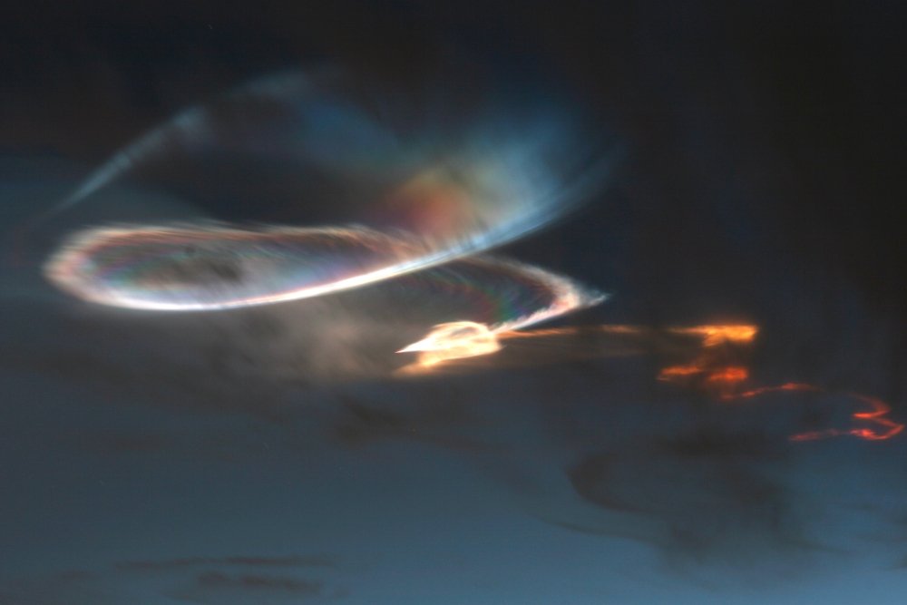
*Cool. ![]() It looks like a snake or dragon. Is rocket exhaust (Minotaur launch from Vandenberg AFB on 9/22). Pic by J. Young.
It looks like a snake or dragon. Is rocket exhaust (Minotaur launch from Vandenberg AFB on 9/22). Pic by J. Young.
What causes the pearly colors? Water droplets and bits of unburnt fuel from the rocket's exhaust freeze in the cold upper atmosphere. When sunlight hits the icy crystals, they glow pastel yellow, red and blue--a phenomenon known as iridescence.
I've seen one rather dramatic example of rocket exhaust, about 8 years ago in the early morning. Launch from White Sands.
As for this one:
amazed onlookers all the way from southern California to Arizona. "It was a beautiful sight to see, lighting up the whole sky," reports Mike O'Leary of El Cajon, CA
--Cindy
We all know [i]those[/i] Venusians: Doing their hair in shock waves, smoking electrical coronas, wearing Van Allen belts and resting their tiny elbows on a Geiger counter...
--John Sladek (The New Apocrypha)
Offline
Like button can go here
#162 2005-09-23 05:51:30
- Grypd
- Member
- From: Scotland, Europe
- Registered: 2004-06-07
- Posts: 1,879
Re: Earth Atmospherics/Weather
It has been asked why are low powered in respect tropical storms more or less instantly becoming monsters like Katrina and now Rita. The answer is that these tropical storms are formed out of depressions coming from the region of Africa but they travel across the Atlantic which has enough power to make them into the storms they are. It is only when they approach Florida and the Caribbean that the warmer air and water allows them to become Hurricanes. Though the water tempatures normally there are still too cold to allow more than the creation of up to level 2 Hurricanes. The problem that created the monsters that Katrina and Rita are is the gulf Of Mexico which is the warmest it has ever been recorded at and as such an energiser for these storms. This is how Rita went from a tropical storm to a category 5 monster in less than 48 hrs.
Terradaily article on raised gulf tempatures
With this we can see why these Hurricanes become monsters but why is the water so warm? Some say it is due to a slow down in the Gulf stream and the Brazil current both of which take Hot water away from the carribean. Some blame El Nino which appears to be forming again. The answer simply is that it is another symptom of a world getting a lot hotter. The trouble is that there is still plenty of time in the current hurricane season for 6 to 9 more Hurricanes to be formed and the water in the Gulf is not cooling fast.
Chan eil mi aig a bheil ùidh ann an gleidheadh an status quo; Tha mi airson cur às e.
Offline
Like button can go here
#163 2005-09-23 05:57:18
- Palomar
- Member
- From: USA
- Registered: 2002-05-30
- Posts: 9,734
Re: Earth Atmospherics/Weather
The problem that created the monsters that Katrina and Rita are is the gulf Of Mexico which is the warmest it has ever been recorded at and as such an energiser for these storms. This is how Rita went from a tropical storm to a category 5 monster in less than 48 hrs.
Terradaily article on raised gulf tempatures
With this we can see why these Hurricanes become monsters but why is the water so warm? Some say it is due to a slow down in the Gulf stream and the Brazil current both of which take Hot water away from the carribean. Some blame El Nino which appears to be forming again. The answer simply is that it is another symptom of a world getting a lot hotter. The trouble is that there is still plenty of time in the current hurricane season for 6 to 9 more Hurricanes to be formed and the water in the Gulf is not cooling fast.
*And lots of people are blaming it entirely on "global warming" and ignoring the scientists who are admitting we don't know why and that it could indeed "simply" be due to a larger natural cycle.
--Cindy
We all know [i]those[/i] Venusians: Doing their hair in shock waves, smoking electrical coronas, wearing Van Allen belts and resting their tiny elbows on a Geiger counter...
--John Sladek (The New Apocrypha)
Offline
Like button can go here
#164 2005-09-23 06:21:54
- Grypd
- Member
- From: Scotland, Europe
- Registered: 2004-06-07
- Posts: 1,879
Re: Earth Atmospherics/Weather
Yes they are blaming it on global warming but we also have evidence that in the water off Mexico itself there is an increased level of carbon dioxide in the water actually it is saturated with the stuff.
Im sorry to say Cindy that with all the changes I see in the world around me and of the changes in weather paterns then it can only be because of global warming. I see the sea right from my house almost a whole degree warmer and animals and plants that should not be here now thriving, traditional plants though are struggling. And im pretty sure it can only be man made. Incidentally you know the adage that plants breathe in more CO2 than they use oxygen. It apparently is wrong in very warm tempatures.
Chan eil mi aig a bheil ùidh ann an gleidheadh an status quo; Tha mi airson cur às e.
Offline
Like button can go here
#165 2005-09-23 06:38:23
- Palomar
- Member
- From: USA
- Registered: 2002-05-30
- Posts: 9,734
Re: Earth Atmospherics/Weather
*Cool.
It looks like a snake or dragon. Is rocket exhaust (Minotaur launch from Vandenberg AFB on 9/22). Pic by J. Young.
What causes the pearly colors? Water droplets and bits of unburnt fuel from the rocket's exhaust freeze in the cold upper atmosphere. When sunlight hits the icy crystals, they glow pastel yellow, red and blue--a phenomenon known as iridescence.
I've seen one rather dramatic example of rocket exhaust, about 8 years ago in the early morning. Launch from White Sands.
As for this one:
amazed onlookers all the way from southern California to Arizona. "It was a beautiful sight to see, lighting up the whole sky," reports Mike O'Leary of El Cajon, CA
*...in this article. Created quite a sensation, apparently. They are beautifully weird to see. ![]()
--Cindy
We all know [i]those[/i] Venusians: Doing their hair in shock waves, smoking electrical coronas, wearing Van Allen belts and resting their tiny elbows on a Geiger counter...
--John Sladek (The New Apocrypha)
Offline
Like button can go here
#166 2005-09-24 07:58:55
- Palomar
- Member
- From: USA
- Registered: 2002-05-30
- Posts: 9,734
Re: Earth Atmospherics/Weather
Scientists nix hurricane blaster idea
*Interesting article.
Atmospheric scientists say it's wishful thinking that we could destroy or even influence something as huge and powerful as a hurricane. They abandoned such a quest years ago after more than two decades of inconclusive government-sponsored research.
Private companies have conducted tests on a much smaller scale, but have made little progress despite initially claiming to erase storm clouds from the atmosphere.
"It would be like trying to move a car with a pea shooter," said hydrometeorologist Matthew Kelsch of the National Center for Atmospheric Research in Boulder. "The amount of energy involved in a hurricane is far greater that anything we're going to impart to it."
Occasionally, somebody suggests detonating a nuclear weapon to shatter a storm.
Researchers say hurricanes would dwarf such measures. For example, Hurricane Rita measures about 400 miles across.
According to the center for atmospheric research, the heat energy released by a hurricane equals 50 to 200 trillion watts or about the same amount of energy released by exploding a 10-megaton nuclear bomb every 20 minutes.
Amazing, huh?
--Cindy
We all know [i]those[/i] Venusians: Doing their hair in shock waves, smoking electrical coronas, wearing Van Allen belts and resting their tiny elbows on a Geiger counter...
--John Sladek (The New Apocrypha)
Offline
Like button can go here
#167 2005-09-28 13:59:49
- Palomar
- Member
- From: USA
- Registered: 2002-05-30
- Posts: 9,734
Re: Earth Atmospherics/Weather
Scientists nix hurricane blaster idea
*Interesting article.
Atmospheric scientists say it's wishful thinking that we could destroy or even influence something as huge and powerful as a hurricane. They abandoned such a quest years ago after more than two decades of inconclusive government-sponsored research.
Private companies have conducted tests on a much smaller scale, but have made little progress despite initially claiming to erase storm clouds from the atmosphere.
"It would be like trying to move a car with a pea shooter," said hydrometeorologist Matthew Kelsch of the National Center for Atmospheric Research in Boulder. "The amount of energy involved in a hurricane is far greater that anything we're going to impart to it."
Occasionally, somebody suggests detonating a nuclear weapon to shatter a storm.
Researchers say hurricanes would dwarf such measures. For example, Hurricane Rita measures about 400 miles across.
According to the center for atmospheric research, the heat energy released by a hurricane equals 50 to 200 trillion watts or about the same amount of energy released by exploding a 10-megaton nuclear bomb every 20 minutes.
Amazing, huh?
*And here's another:
Spill the oil, dig that hurricane?
A rundown of all the various ways people have considered trying to halt, slow or even snuff out a hurricane before it can start in good earnest.
I agree with the final assessment. ![]()
--Cindy
We all know [i]those[/i] Venusians: Doing their hair in shock waves, smoking electrical coronas, wearing Van Allen belts and resting their tiny elbows on a Geiger counter...
--John Sladek (The New Apocrypha)
Offline
Like button can go here
#168 2005-09-28 14:12:34
- SpaceNut
- Administrator
- From: New Hampshire
- Registered: 2004-07-22
- Posts: 30,758
Re: Earth Atmospherics/Weather
Yup, just get out of its way...
Offline
Like button can go here
#169 2005-09-28 16:29:15
- Yang Liwei Rocket
- Member
- Registered: 2004-03-03
- Posts: 993
Re: Earth Atmospherics/Weather
Current climate models forecast that the impact of global warming will increase the further a region is from the equator. Ice thickness results from ESA's CryoSat will shortly indicate whether these predictions are on the right lines.
http://www.esa.int/SPECIALS/Cryosat/SEMA0R4Y3EE_0.html
ESA's Envisat satellite has been continuously observing the Earth with a suite of ten instruments for the last three and a half years. A major workshop is about to bring together users of Envisat's two most complementary sensors: MERIS, which acquires multispectral imagery of the planet's ocean, land and atmosphere, and AATSR, a radiometer measuring global surface and cloud temperatures down to a fraction of a degree.
http://www.esa.int/esaEO/SEMPPQ7X9DE_index_0.html
This season's Antarctic ozone hole has swollen to an area of ten million square kilometres from mid-August - approximately the same size as Europe and still expanding. It is expected to reach maximum extent during September, and ESA satellites are vital for monitoring its development.
This year's hole is large for this time of year, based on results from the last decade: only the ozone holes of 1996 and 2000 had a larger area at this point in their development.
http://www.esa.int/esaEO/SEM712A5QCE_environment_0.html
'first steps are not for cheap, think about it...
did China build a great Wall in a day ?' ( Y L R newmars forum member )
Offline
Like button can go here
#170 2005-09-30 12:27:00
- Palomar
- Member
- From: USA
- Registered: 2002-05-30
- Posts: 9,734
Re: Earth Atmospherics/Weather
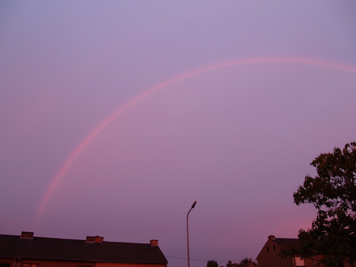
*There was no Sun (had set). There was no rain. But yet... ![]()
Taken by Bruno Nolf of Belgium [Rik...any chance you know that guy?] on September 26. He took the photo 4 minutes after sunset.
"Furthermore, according to Nolf, there was no rain falling and none visible on local weather radar!"
Interesting explanation as to how this occurred:
Cowley and colleague Gunther Konnen, a meteorologist, may have an explanation: Thousands of feet above Nolf, the sun had not yet set. (Think about it: "If your flight has ever taken off shortly after sunset you will see the sun rising again as the airplane climbs," notes Cowley.) Somewhere off in the distance, they speculate, a mile-high rainstorm that somehow evaded the radar caught the reddened rays of the setting sun, producing the Bruno's 'bow.
--Cindy
We all know [i]those[/i] Venusians: Doing their hair in shock waves, smoking electrical coronas, wearing Van Allen belts and resting their tiny elbows on a Geiger counter...
--John Sladek (The New Apocrypha)
Offline
Like button can go here
#171 2005-10-04 08:39:35
- Palomar
- Member
- From: USA
- Registered: 2002-05-30
- Posts: 9,734
Re: Earth Atmospherics/Weather
October predicted to be busy tropical storm/hurricane month
*Good grief. ![]() Three tropical storms, two hurricanes and 1 major hurricane forecasted for this month. And we've still got November to get through.
Three tropical storms, two hurricanes and 1 major hurricane forecasted for this month. And we've still got November to get through. ![]()
Tropical Storm Stan will likely develop into a hurricane and strike Mexico this week.
--Cindy
We all know [i]those[/i] Venusians: Doing their hair in shock waves, smoking electrical coronas, wearing Van Allen belts and resting their tiny elbows on a Geiger counter...
--John Sladek (The New Apocrypha)
Offline
Like button can go here
#172 2005-10-04 13:12:53
- Palomar
- Member
- From: USA
- Registered: 2002-05-30
- Posts: 9,734
Re: Earth Atmospherics/Weather
October predicted to be busy tropical storm/hurricane month
*Good grief.
Three tropical storms, two hurricanes and 1 major hurricane forecasted for this month. And we've still got November to get through.
Tropical Storm Stan will likely develop into a hurricane and strike Mexico this week.
*That was mighty quick. Stan is now a hurricane AND has struck Mexican coast. I just posted the above earlier this a.m.
Anywho, Stan's packing 80 mph winds. 10 inches of rain possible in some areas. Central America feeling effects too: 38 people dead in El Salvador from flooding and landslides already. Stan hit 85 miles SE of Veracruz, Mexico and is moving along at a slow 7 mph. Is currently a Cat 1.
Pemex oil production/refining questioned, i.e. impact on the U.S., as a result.
--Cindy
We all know [i]those[/i] Venusians: Doing their hair in shock waves, smoking electrical coronas, wearing Van Allen belts and resting their tiny elbows on a Geiger counter...
--John Sladek (The New Apocrypha)
Offline
Like button can go here
#173 2005-10-05 06:25:09
- Palomar
- Member
- From: USA
- Registered: 2002-05-30
- Posts: 9,734
Re: Earth Atmospherics/Weather
Say hello to Tropical Storm Tammy
*She's expected to remain a TS. Current wind speeds are 40 mph. She's off Florida's east coast, aprox 20 miles east of Cape Canaveral at the time the article was posted. Is moving N - NW at 16 mph.
Area from Cocoa Beach to Santee River, S.C. have been issued TS warnings. 3 to 5 inches of rainfall expected on average; some areas may receive 8 to 10 inches. Tornadoes also a possibility.
--Cindy
We all know [i]those[/i] Venusians: Doing their hair in shock waves, smoking electrical coronas, wearing Van Allen belts and resting their tiny elbows on a Geiger counter...
--John Sladek (The New Apocrypha)
Offline
Like button can go here
#174 2005-10-05 10:25:15
- SpaceNut
- Administrator
- From: New Hampshire
- Registered: 2004-07-22
- Posts: 30,758
Re: Earth Atmospherics/Weather
Yup just saw this, what a drenging we are getting...
We had wondered why huricans intensify when the hit the gulf.
I had put forth that the sediment build up which makes the gulf over time more shallow was a cause. Well here is a study of the effects of
Gulf Warm-Water Eddies Intensify Hurricane Changes
The Loop Current is a horseshoe-shaped feature that flows clockwise, transferring warm subtropical waters from the Caribbean Sea through the Yucatan Straits into the Gulf of Mexico.
This year, the Loop Current extended deep into the Gulf of Mexico during hurricane season. Currents at this time of year typically become unsteady and pinch off deep, warm eddies, said Shay. The warm water then becomes ideal for hurricanes in the process of intensifying.
Offline
Like button can go here
#175 2005-10-06 04:54:56
- Palomar
- Member
- From: USA
- Registered: 2002-05-30
- Posts: 9,734
Re: Earth Atmospherics/Weather
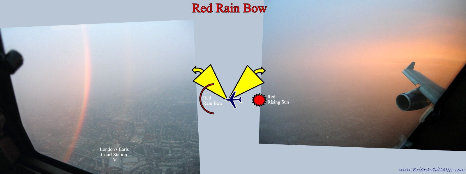
*Hmmmm. It must be the end of the world! ![]()
Photo from B. Whittaker, taken during flight on 9/15. Sunrise behind the airplane, 360-degree red rainbows ahead.
Says atmospheric optics expert Les Cowley: "These beautiful red bows, an inner primary and outer secondary, show us that when the ground does not get in the way, rainbows can be almost complete circles."
Wow. I've not flown much, so haven't seen this personally. Cool. ![]()
And how about some zero-order glow? --
That's not all: "The glow in the east is not just a sunrise; it is another rainbow phenomenon called the 'zero order glow.' This glow is produced by light that goes through raindrops without being internally reflected. Around 95% of the light does so--textbooks often give a misleading ray diagram that implies that all the sun's light goes into the rainbow."
"The next time you see a sunset (or sunrise) rainbow, look towards the sun to see the golden light of the zero order glow."
Photo, info courtesy spaceweather.com
--Cindy
We all know [i]those[/i] Venusians: Doing their hair in shock waves, smoking electrical coronas, wearing Van Allen belts and resting their tiny elbows on a Geiger counter...
--John Sladek (The New Apocrypha)
Offline
Like button can go here