New Mars Forums
You are not logged in.
- Topics: Active | Unanswered
Announcement
#126 2008-03-10 07:12:14
- cIclops
- Member
- Registered: 2005-06-16
- Posts: 3,230
Re: Real images of Mars
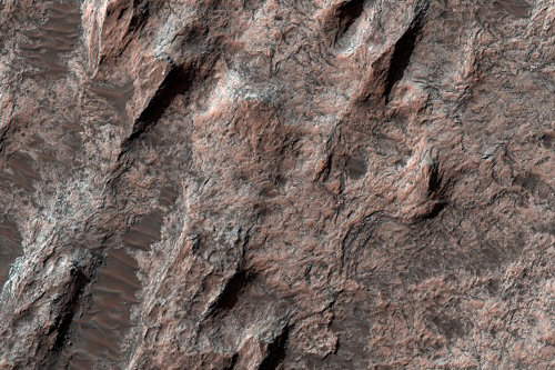
Light-Toned Rock in Southern Highlands (MRO/HiRISE) - imaged 20 Jan 2008
This image shows a broad expanse of rock in the southern highlands of Mars. This outcrop is located on the floor of a large, old impact crater, now partially filled in, and shows the nature of some of the infilling material.
At large scale, the outcrop shows a series of linear aligned ridges. These are yardangs, formed by aeolian (wind) erosion. As the wind erodes the rock, it shapes it into aerodynamic forms. At smaller scale, the wind has carved fine grooves and scallops into the rock surface, aligned in the same direction as the large yardangs.
At full resolution, the rock is heavily fractured. At many sites, the rock is breaking into angular boulders. The largest cracks appear to have developed into shallow troughs, since they are weak sites which are most easily eroded. Troughs and other low areas have been filled by wind-blown sand or dust.
One possible source for this rock is volcanic ash. The outcrop lies between Hadriaca Patera and Tyrrhena Patera, two ancient volcanoes. These volcanoes appear different from the giant shield volcanoes like Olympus Mons; it has been suggested that they erupted more explosively, while the large shields were built mostly by lava flows.
[color=darkred]Let's go to Mars and far beyond - triple NASA's budget ![/color] [url=irc://freenode#space] #space channel !! [/url] [url=http://www.youtube.com/user/c1cl0ps] - videos !!![/url]
Offline
Like button can go here
#127 2008-03-11 13:27:09
- cIclops
- Member
- Registered: 2005-06-16
- Posts: 3,230
Re: Real images of Mars
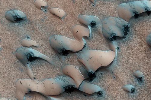
Defrosting Polar Sand Dunes (MRO/HiRISE) - imaged 27 Jan 2008
This image shows dunes near the north pole of Mars. The north pole is surrounded by a vast “sea” of basaltic sand dunes, and the dunes imaged here are similar to barchan dunes that are commonly found in desert regions on Earth.
Barchan dunes are generally crescent-shaped with a steep slip face bordered by horns oriented in the downwind direction. Barchan dunes form by winds blowing mainly in one direction and thus are good indicators of the dominant wind direction when the dunes formed. In this case, the strongest winds blew approximately south to north.
The dunes and surrounding surface appear bright because they are covered with seasonal frost left over from the northern hemisphere winter. Sunlight is now falling on the north polar region, and carbon dioxide frost that accumulated during winter is sublimating (going directly from solid to gas) and the surface beneath the frost is being revealed. Composed primarily of basaltic sand, the dunes will appear dark during the northern hemisphere summer. The dark spots are areas where some of this frost has begun to sublime away, and/or where wind has exposed the underlying dark sand.
[color=darkred]Let's go to Mars and far beyond - triple NASA's budget ![/color] [url=irc://freenode#space] #space channel !! [/url] [url=http://www.youtube.com/user/c1cl0ps] - videos !!![/url]
Offline
Like button can go here
#128 2008-03-14 05:43:08
- cIclops
- Member
- Registered: 2005-06-16
- Posts: 3,230
Re: Real images of Mars
(spacer)
[color=darkred]Let's go to Mars and far beyond - triple NASA's budget ![/color] [url=irc://freenode#space] #space channel !! [/url] [url=http://www.youtube.com/user/c1cl0ps] - videos !!![/url]
Offline
Like button can go here
#129 2008-03-14 05:43:29
- cIclops
- Member
- Registered: 2005-06-16
- Posts: 3,230
Re: Real images of Mars
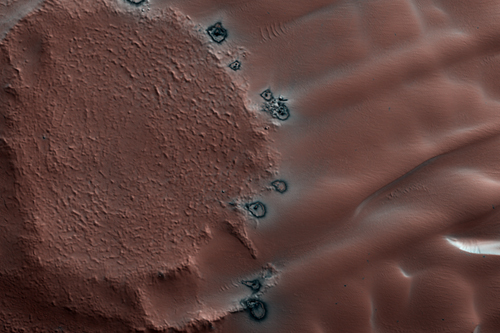
Defrosting Northern Dunes (MRO/HiRISE) - imaged 7 Feb 2008
In northern winter a seasonal polar cap composed of carbon dioxide ice (dry ice) forms in the north polar region. This cap covers a vast sea of dunes at high northern latitudes. In the spring the ice sublimates (evaporates directly from ice to gas) and this active process loosens and moves tiny dust particles.
[color=darkred]Let's go to Mars and far beyond - triple NASA's budget ![/color] [url=irc://freenode#space] #space channel !! [/url] [url=http://www.youtube.com/user/c1cl0ps] - videos !!![/url]
Offline
Like button can go here
#130 2008-03-17 10:40:12
- cIclops
- Member
- Registered: 2005-06-16
- Posts: 3,230
Re: Real images of Mars
(spacer)
[color=darkred]Let's go to Mars and far beyond - triple NASA's budget ![/color] [url=irc://freenode#space] #space channel !! [/url] [url=http://www.youtube.com/user/c1cl0ps] - videos !!![/url]
Offline
Like button can go here
#131 2008-03-17 10:42:00
- cIclops
- Member
- Registered: 2005-06-16
- Posts: 3,230
Re: Real images of Mars
Proposed MSL Landing Site in Mawrth Vallis (MRO/HiRISE) - imaged 15 Jan 2008
Mawrth Vallis has a rich mineral diversity, including clay minerals that formed by the chemical alteration of rocks or loose “regolith” (soil) by water. The CRISM instrument on the MRO spacecraft detects a variety of clay minerals here, which could signify different processes of formation. The high resolution of the HiRISE camera helps us to see and trace out layers, polygonal fractures, and with CRISM, examine the distribution of various minerals across the surface.
This surface is scientifically compelling for the Mars Science Laboratory (MSL) rover, although some of the terrain can be somewhat rough. Scientists use HiRISE images to find the safest possible landing site for the rover.
[color=darkred]Let's go to Mars and far beyond - triple NASA's budget ![/color] [url=irc://freenode#space] #space channel !! [/url] [url=http://www.youtube.com/user/c1cl0ps] - videos !!![/url]
Offline
Like button can go here
#132 2008-03-20 09:14:51
- cIclops
- Member
- Registered: 2005-06-16
- Posts: 3,230
Re: Real images of Mars
(this message is intentionally blank)
[color=darkred]Let's go to Mars and far beyond - triple NASA's budget ![/color] [url=irc://freenode#space] #space channel !! [/url] [url=http://www.youtube.com/user/c1cl0ps] - videos !!![/url]
Offline
Like button can go here
#133 2008-03-20 09:17:35
- cIclops
- Member
- Registered: 2005-06-16
- Posts: 3,230
Re: Real images of Mars
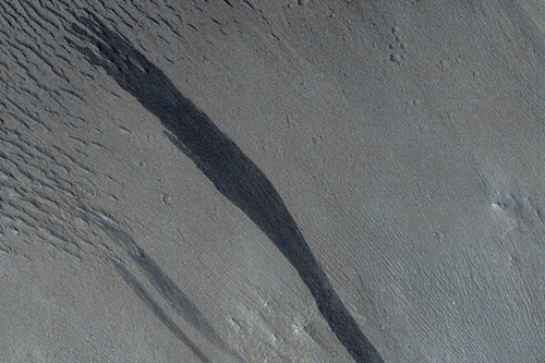
Layers and Slope Streaks within Valleys along the Highland-Lowland Boundary (MRO/HiRISE) - imaged 4 Oct 2007
This image shows slope streaks and layering on the walls of a valley along the border between the Martian southern highlands and northern lowlands (see the subimage). At the bottom of the valley and in the lower portion of the valley walls are many large dunes.
The slope streaks generally start at a point source and widen downslope as a single streak or branch into multiple streaks. Some of the slope streaks show evidence that downslope movement is being diverted around obstacles, such as large boulders. In particular, several of the slope streaks in this image appear to be diverting around individual dunes, with downslope movement occurring in the low troughs between the dunes. The darkest slope streaks are youngest and cross cut and lie on top of the older and lighter-toned streaks. The lighter-toned streaks are believed to be dark streaks that are lightening with time as new dust is deposited on their surface.
Slope streak formation is among the few known processes currently active on Mars. Since the slope streaks in this image appear to superpose (lie on top of) the surfaces between individual dunes, the streaks most likely formed more recently and are younger than the dunes.
Many hypotheses have been proposed for the formation of slope streaks including dry avalanching, geochemical weathering, liquid stains or flows, and moisture wickering. Recent observations from HiRISE images have revealed that the dark interior of slope streaks is lower in elevation than the surroundings, suggesting that material must have been removed in the formation of the streak.
[color=darkred]Let's go to Mars and far beyond - triple NASA's budget ![/color] [url=irc://freenode#space] #space channel !! [/url] [url=http://www.youtube.com/user/c1cl0ps] - videos !!![/url]
Offline
Like button can go here
#134 2008-03-24 12:47:49
- cIclops
- Member
- Registered: 2005-06-16
- Posts: 3,230
Re: Real images of Mars
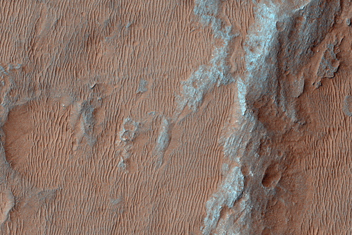
Proposed MSL Site in Holden Crater (MRO/HiRISE) - imaged 22 Sep 2007
Alluvial fans are deposits of sand, gravel, and sometimes boulders that were eroded from steep slopes (mountain fronts or basin walls) and deposited on plains at the base of the slope. Erosion of deep alcoves into the walls of Holden Crater (155 kilometers in diameter) provided sediment to these alluvial fans, that have coalesced into a large deposit called a bajada.
Most Martian impact craters that contain large alluvial fans are clustered between 18 and 29 degrees South, and the Holden bajada is the largest of these deposits recognized to date. Inverted channels are located on the alluvial fans, where the old stream beds were more resistant to later wind erosion than the fine-grained sediment deposited outside the channels; preferential erosion left the channel beds exposed as ridges. Many ripples of more recent, wind-blown sand are found between the older inverted channels.
TheMars Science Laboratory (MSL) would land on the bajada and drive across the traversable ripples to the south, where the inverted channels, layers, and evidence for past fluvial activity are located.
[color=darkred]Let's go to Mars and far beyond - triple NASA's budget ![/color] [url=irc://freenode#space] #space channel !! [/url] [url=http://www.youtube.com/user/c1cl0ps] - videos !!![/url]
Offline
Like button can go here
#135 2008-03-28 10:58:35
- cIclops
- Member
- Registered: 2005-06-16
- Posts: 3,230
Re: Real images of Mars
(this message is intentionally blank)
[color=darkred]Let's go to Mars and far beyond - triple NASA's budget ![/color] [url=irc://freenode#space] #space channel !! [/url] [url=http://www.youtube.com/user/c1cl0ps] - videos !!![/url]
Offline
Like button can go here
#136 2008-03-28 11:01:37
- cIclops
- Member
- Registered: 2005-06-16
- Posts: 3,230
Re: Real images of Mars
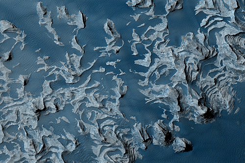
Slab of Layered Material in Aureum Chaos (MRO/HiRISE) - imaged 24 Jan 2008
This image shows a large outcrop of layered rock in Aureum Chaos, an area that has apparently collapsed, leaving a region of irregular knobs and hills. Unlike many of the knobs, the light outcrop shows distinct, nearly horizontal layers. This may indicate that it was deposited after the collapse of the Chaos.
Multiple layers are exposed in the outcrop, which is several kilometers long. The best exposures, in the north wall, reveal multiple different rock units with different color and texture. The bottom unit is very light-toned and shows little internal structure other than occasional fractures. Above this is a darker unit with a broken appearance, followed by fine, stepped layers. The top of the outcrop consists of knobs and spires that may be eroded remnants of the top of the stack. Many of the units show variations in color which could indicate further divisions.
This package of rocks may have been deposited by multiple processes. Alternatively, the same process could have delivered sediments from different sources. Some possible origins include dust or volcanic ash settling from the atmosphere, wind-blown sand, or material deposited in lakes.
[color=darkred]Let's go to Mars and far beyond - triple NASA's budget ![/color] [url=irc://freenode#space] #space channel !! [/url] [url=http://www.youtube.com/user/c1cl0ps] - videos !!![/url]
Offline
Like button can go here
#137 2008-04-02 13:13:00
- cIclops
- Member
- Registered: 2005-06-16
- Posts: 3,230
Re: Real images of Mars
(this message is intentionally blank)
[color=darkred]Let's go to Mars and far beyond - triple NASA's budget ![/color] [url=irc://freenode#space] #space channel !! [/url] [url=http://www.youtube.com/user/c1cl0ps] - videos !!![/url]
Offline
Like button can go here
#138 2008-04-02 13:17:59
- cIclops
- Member
- Registered: 2005-06-16
- Posts: 3,230
Re: Real images of Mars
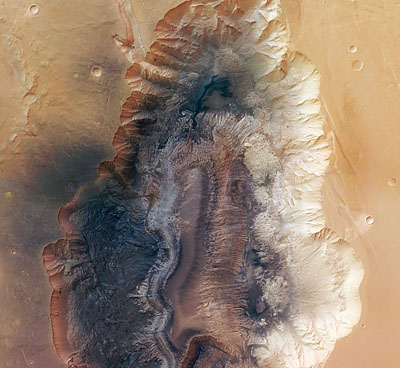
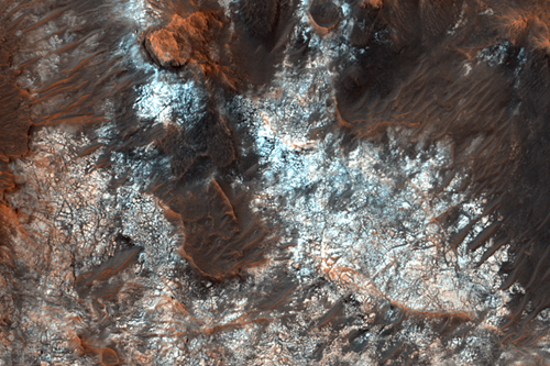
Hebes Chasma, Valles Marineris (MEX/HRSC) - imaged 16 Sep 2005
(no reason given why this imaged was released 28 Mar 2008)
Hebes Chasma is an enclosed trough, almost 8000 m deep, in Valles Marineris, the Grand Canyon of Mars, where water is believed to have flowed. The High Resolution Stereo Camera (HRSC) on ESA’s Mars Express studied the area providing new pictorial clues to its history.
Hebes Chasma is located at approximately 1° south and 282° east. Image data was obtained on 16 September 2005 with a ground resolution of approximately 15 m/pixel.
[color=darkred]Let's go to Mars and far beyond - triple NASA's budget ![/color] [url=irc://freenode#space] #space channel !! [/url] [url=http://www.youtube.com/user/c1cl0ps] - videos !!![/url]
Offline
Like button can go here
#139 2008-04-06 04:25:51
- cIclops
- Member
- Registered: 2005-06-16
- Posts: 3,230
Re: Real images of Mars
(this message is intentionally blank)
[color=darkred]Let's go to Mars and far beyond - triple NASA's budget ![/color] [url=irc://freenode#space] #space channel !! [/url] [url=http://www.youtube.com/user/c1cl0ps] - videos !!![/url]
Offline
Like button can go here
#140 2008-04-06 04:27:56
- cIclops
- Member
- Registered: 2005-06-16
- Posts: 3,230
Re: Real images of Mars
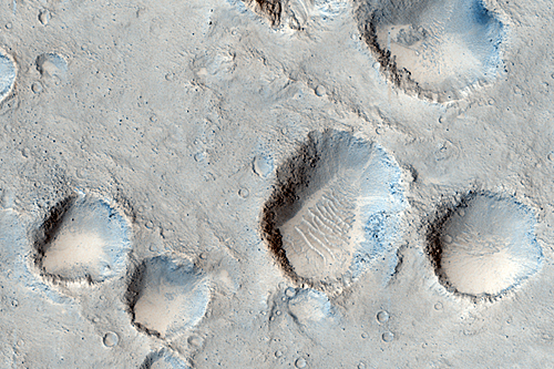
Crater Cluster in Chryse Planitia (MRO/HiRISE) - imaged 28 Jan 2008
This image shows a cluster of impact craters in Chryse Planitia, near the outlet of one of Mars’ giant outflow channels.
The craters are loosely aligned in a chain running from northwest to southeast. Clusters like this form when an asteroid or comet impacts the surface and forms a large crater; material thrown out of that crater often forms streaks or rays containing many small craters from the impact of ejected blocks. These secondary craters are sometimes more irregularly shaped since they are typically less energetic impacts; many of the craters in this image are not quite circular.
An interesting feature to note is the dark material in many of the larger craters. What accounts for this? The largest craters trap wind-blown sand most effectively, but many of the smaller, shallower craters also contain ripples suggesting that they also trap sand or dust.
An alternative possibility is that these craters have excavated to a deeper layer of different material. A combination of these processes is also possible, since smaller craters may be more easily buried.
[color=darkred]Let's go to Mars and far beyond - triple NASA's budget ![/color] [url=irc://freenode#space] #space channel !! [/url] [url=http://www.youtube.com/user/c1cl0ps] - videos !!![/url]
Offline
Like button can go here
#141 2008-04-09 16:47:51
- cIclops
- Member
- Registered: 2005-06-16
- Posts: 3,230
Re: Real images of Mars
(this message is intentionally blank)
[color=darkred]Let's go to Mars and far beyond - triple NASA's budget ![/color] [url=irc://freenode#space] #space channel !! [/url] [url=http://www.youtube.com/user/c1cl0ps] - videos !!![/url]
Offline
Like button can go here
#142 2008-04-09 16:48:27
- cIclops
- Member
- Registered: 2005-06-16
- Posts: 3,230
Re: Real images of Mars

Not Mars but Phobos (MRO/HiRISE) - imaged 23 Mar 2008
more details, 3D & high resolution images
The High Resolution Imaging Science Experiment (HiRISE) camera on NASA's Mars Reconnaissance Orbiter took two images of the larger of Mars' two moons, Phobos, within 10 minutes of each other on March 23, 2008. This is the first, taken from a distance of about 6,800 kilometers (about 4,200 miles). It is presented in color by combining data from the camera's blue-green, red, and near-infrared channels.
The illuminated part of Phobos seen in the images is about 21 kilometers (13 miles) across. The most prominent feature in the images is the large crater Stickney in the lower right. With a diameter of 9 kilometers (5.6 miles), it is the largest feature on Phobos.
The color data accentuate details not apparent in black-and-white images. For example, materials near the rim of Stickney appear bluer than the rest of Phobos. Based on analogy with materials on our own moon, this could mean this surface is fresher, and therefore younger, than other parts of Phobos.
A series of troughs and crater chains is obvious on other parts of the moon. Although many appear radial to Stickney in this image, recent studies from the European Space Agency's Mars Express orbiter indicate that they are not related to Stickney. Instead, they may have formed when material ejected from impacts on Mars later collided with Phobos. The lineated textures on the walls of Stickney and other large craters are landslides formed from materials falling into the crater interiors in the weak Phobos gravity (less than one one-thousandth of the gravity on Earth).
In the full-resolution version of this image, a pixel encompasses 6.8 meters (22 feet), providing a resolution (smallest visible feature) of about 20 meters (about 65 feet). The image is in the HiRISE catalog as PSP_007769_9010.
[color=darkred]Let's go to Mars and far beyond - triple NASA's budget ![/color] [url=irc://freenode#space] #space channel !! [/url] [url=http://www.youtube.com/user/c1cl0ps] - videos !!![/url]
Offline
Like button can go here
#143 2008-04-13 14:24:50
- Vincent
- Banned
- From: North Carolina USA
- Registered: 2008-04-13
- Posts: 623
Re: Real images of Mars
cIclops
Nice images. Nothing like kicking around on Mars. Thought I would throw out a couple.
The polar sand dunes in the north are interesting. A type of unknown process for sure. They will be looking for life in the ice with the next Lander. On Earth it is red against the white snow. This is a crop of your image or close by. I put a box by the red spot in the white frost or geyser induced snow spray.
Vincent

Argument expected.
I don't require agreement when presenting new ideas.
-Dana Johnson
Offline
Like button can go here
#144 2008-04-13 15:14:14
- Vincent
- Banned
- From: North Carolina USA
- Registered: 2008-04-13
- Posts: 623
Re: Real images of Mars
This is one of my favorites from Pathfinder at, Sagan Memorial Station.
Morning Clouds.
Mars has tremendous temperatures swings as we all know with saturation even at the surface, looks like Earth.
The forecast may go,
Morning clouds giving way to partly to mostly sunny skies. Continued cold with light winds.
Vincent

Argument expected.
I don't require agreement when presenting new ideas.
-Dana Johnson
Offline
Like button can go here
#145 2008-04-14 02:25:46
- cIclops
- Member
- Registered: 2005-06-16
- Posts: 3,230
Re: Real images of Mars
Thanks for posting more images Vincent! What's the source of the first one, it looks like a fresh impact crater. Yes, martian clouds are fascinating and so Earth like ... there's a couple of movies of them here
[color=darkred]Let's go to Mars and far beyond - triple NASA's budget ![/color] [url=irc://freenode#space] #space channel !! [/url] [url=http://www.youtube.com/user/c1cl0ps] - videos !!![/url]
Offline
Like button can go here
#146 2008-04-14 03:00:01
- Belinda
- Member
- From: UK
- Registered: 2004-12-03
- Posts: 31
Re: Real images of Mars
it looks like a fresh impact crater.
Not some kind of dust effect?
Offline
Like button can go here
#147 2008-04-14 03:46:16
- Vincent
- Banned
- From: North Carolina USA
- Registered: 2008-04-13
- Posts: 623
Re: Real images of Mars
The images on the dunes look like a geyser. Sort of like the spiders in the south polar region minus the ground frozen CO2.
The mud flows and wind swept snow from the eruption are clearly visible. The image is a crop from the defrosting dune image from the MRO release JP2000
http://hirise.lpl.arizona.edu/PSP_007193_2640
The clouds are different because the seem to be more low and mid level clouds vs. the high wispy convective cirrus type clouds.
Vincent
Argument expected.
I don't require agreement when presenting new ideas.
-Dana Johnson
Offline
Like button can go here
#148 2008-04-14 05:20:51
- cIclops
- Member
- Registered: 2005-06-16
- Posts: 3,230
Re: Real images of Mars
There we go, four different explanations from three people for the same image ![]()
[color=darkred]Let's go to Mars and far beyond - triple NASA's budget ![/color] [url=irc://freenode#space] #space channel !! [/url] [url=http://www.youtube.com/user/c1cl0ps] - videos !!![/url]
Offline
Like button can go here
#149 2008-04-14 09:58:46
- Vincent
- Banned
- From: North Carolina USA
- Registered: 2008-04-13
- Posts: 623
Re: Real images of Mars
cIclops
Interpretation is knowledge based. You brought it up. How do you get impact from that image?
Standing by.
Vincent
Argument expected.
I don't require agreement when presenting new ideas.
-Dana Johnson
Offline
Like button can go here
#150 2008-04-15 04:24:42
- cIclops
- Member
- Registered: 2005-06-16
- Posts: 3,230
Re: Real images of Mars
Because it looks like a splash pattern.
Yes, different people see different things based on their knowledge and experience even when the source of their perception is identical (within the variation of the display devices).
[color=darkred]Let's go to Mars and far beyond - triple NASA's budget ![/color] [url=irc://freenode#space] #space channel !! [/url] [url=http://www.youtube.com/user/c1cl0ps] - videos !!![/url]
Offline
Like button can go here