New Mars Forums
You are not logged in.
- Topics: Active | Unanswered
Announcement
#126 Re: Life on Mars » Utah Microbes Point to Mars - Research into extremophiles » 2004-05-19 22:40:44
this is udderly fascinating. definately a must-read.
As the conditions on early Mars got colder and harsher, it lost liquid water through evaporation or sequestration into permafrost.
Remaining bodies of water would have been increasingly salty places, and then finally all liquid water disappeared, and the salt deposits eventually lithified into the evaporate rocks the rover sees today.
Any early Martian microbe would have had to withstand a high salt environment and intense UV radiation. Sound familiar?
...Many scientists have argued for some time that if bacteria can survive such conditions here, why not on Mars? Now, Opportunity has proved bodies of open water did once exist and so shown us that the Red Planet is prime real estate after all.
...In 2000, researchers actually managed to revive 250-million-year-old halo-tolerant bacteria found on Earth in underground salt crystals. Could we possibly do the same with Martian microbes?

#127 Re: Water on Mars » Evidence for falling snow - Opportunity image shows pillar of light » 2004-05-18 21:59:50
It is now May 18, 2004 and several of the near horizon views of the sun or setting sun show characteristics which still suggest we are observing through regular ice crystals or perhaps even falling snow somewhere in the line of sight to the sun. We don't seem to see the saturated image pixels we were seeing earlier.
One of the pseudo color images on the http://www.lyle.org]www.lyle.org site even showed a ring around the just-set sun, although I haven't measured and calculated its angular separation to confirm that that is what it actually is as observed for such situations here on earth.
There is a lot to be learned from these images.
*Hi Rex:
--Cindy
i think he was referring to http://www.lyle.org/mars/imagery/1P1378 … .html]this image or http://www.lyle.org/mars/bysol/1-109.html]others like it from sol 109
IMHO, i think the "pillar of light" is just a reflection off the inside of the camera lens or housing (the camera does happen to be pointing directly into the sun, so there should be lots of flares and other lens artifacts depending on the camera angles), the images with the vertical line pointing UP as oppsed to down, are quite odd. Also, note that you can see the pillar of light superimposed over the ground also. If it were truly an atmospheric phenomenon (such as a sundog type of effect) then it would only be seen in areas of the sky. speaking of sundogs, im sure they exist on mars and the rover should be able to get some good images if we get lucky, but i dont think this is anything like that. Sundogs are most usually seen at angles that are horizontal to the atmospheric horizon, not vertical.
![http://www.lyle.org/mars/imagery/1P1378 … .html]this](http://www.lyle.org/mars/imagery/1P137881459EFF2403P2682L4M1.JPG.html]this)
i cant find that pseudocolor image of the ring around the sun, though.
#128 Re: Water on Mars » .Wet Mars or Dry Mars? - Another spacedaily spoilsport » 2004-05-18 21:50:31
This MOC image shows some nice gullies;
http://www.msss.com/moc_gallery/e01_e06 … ...474.jpg
A couple of them have some nice meanders.
Usually, meanders means the liquid flowed for some time.
Thanks, truly some excellent shots of gullies!
http://www.msss.com/moc_gallery/e01_e06 … .jpg]first image you refer to looks like theres a lot of dust accumulation. i wonder if dust accumulates and avalanches downslope and if this type of erosion might create similar features as that shown in the image.
![http://www.msss.com/moc_gallery/e01_e06 … .jpg]first](http://www.msss.com/moc_gallery/e01_e06/full_jpg_map/E02/E0201423.jpg]first)
http://www.msss.com/moc_gallery/e01_e06 … 74.jpg]the second image of gullies however, is much clearer to see whats going on and begs a much different explanation. I'll bet ('hope' at least) that these gullies are actively forming even today. Heres a tentative albeit incomplete hypothesis (has anyone shot down this idea yet?):
![http://www.msss.com/moc_gallery/e01_e06 … 74.jpg]the](http://www.msss.com/moc_gallery/e01_e06/full_jpg_non_map/E05/E0502474.jpg]the)
Notice that theres a lot of frost accumulation in this area that is now almost gone this season.
1) The seasonal cycle deposits frost in varying concentrations depending upon the conditions in close proximity to the water vapor laden air.
2) The frost accumulates relatively thinly on the plains in contrast to the outcrops and overhangs which are colder since theyre likely to be out of sunlight more often. These colder areas, being a perfect heat sink, collect any water vapor from the air that passes over them since any water would tend to readily condense there.
3) The frost accumulates into realtively thick ice cakes over the season.
4) When the seasons comearound, the ice cakes might melt and drip out suddenly as warm air makes its way over them.
5) excruciatingly slow and gradual gully formation occurs over tens of thousands of years, as a repeated series of brief and relatively unproductive erosional sessions consisting of small amounts of slurry carving the gullies on their way downslope.
#129 Re: Unmanned probes » Nasa hoax: why?!? » 2004-05-12 15:05:36
That is due to the exposure setting of the shot where the (relastively) bright sky causes the CCD element to "bleed over" vertically into neighborhood CCD elements/pixels.
A good explanation was posted on here: http://mer.rlproject.com/index.php?show … wtopic=211 And here is an example of a smaller "overexposure bleed", this time on the heatshield: http://www.lyle.org/mars/imagery/1P1374 … 1.JPG.html
A little research instead of tin-foil grabbing would be useful sometimes...
Its a given that pixel bleed due to oversaturation of the ccd occurs and usually it manifests in things like streaks and blotches like as on the heatshield and on metal parts of the rover when they are in the pictures or even on http://www.lyle.org/mars/imagery/2P1356 … l]features in the rocks (was that a glint from a crystal facet? i still want to know).
![http://www.lyle.org/mars/imagery/2P1356 … l]features](http://www.lyle.org/mars/imagery/2P135681876EFF3000P2552R1M1.JPG.html]features)
Having it mask out in a subtle way a signifficant portion of the terrain horizon is a bit more interesting. As can be seen in http://www.lyle.org/~markoff/processed/ … 1.JPG]this color composite of the area in question, the most-removed areas do correspond to areas with more sky in them, leading to greater oversaturation bleed in these areas. Its not a very consistent effect, but i think its true that this is the cause of this phenomenon. 
Its likely that this problem is widespread and we just havent noticed this much before since you need a sequence such as this to see it in context. If this oversaturation problem really happens this easily in only certain filters, then we should be able to go back and see lots of these paticular filter images with extreme bleedover like this (http://www.lyle.org/mars/imagery/1P137167255ESF2019P2566L7M1.JPG.html]heres an extreme example), provided the sky is a small part of the image, especially at Meridiani where the contrast between the dark soil and the sky is so extreme, so any image with a thin section of sky has been compromised, especially when, like this image, it has a dark crater interior you want to get a good exposure of. So that must be whats going on. I dont think NASA has any motive to doctor the images like this.
![http://www.lyle.org/~markoff/processed/ … 1.JPG]this](http://www.lyle.org/~markoff/processed/1P137165054ESF2019P2357L234567M1.JPG]this)
On the side, why is it that these images are in the aspect ratio they are? they have apparently tried to crop off as much sky as possible to get better contrast of the ground before making the exposure, but also resulting this oversaturation problem for certai filters due to the fact that a small portion of the sky also made it into the images?
As for the SKY KOLOR, they should fill in a "true" Mars sky color based on the composite data from the time the photos are taken, and this is likely to be a range of colors, which of course are compromised due to the above ccd limitation principle. The only source photos we should make composites from to guage sky color (at least to get an accurate idea of the true color of the Martian sky at that timeframe) should be those images that ONLY include sky in them (ok maybe a little ground is ok), since based on the same principle, the true color value of the sky per each filter shot is compromised by the values in the ground effecting how light or dark the sky gets recorded in the resultant exposure for each filter shot (if the sky gets pegged to 255 in one filter due to this ground/sky contrast scenario and another filter doesnt result in a pegged-out sky, then the sky color is compromised). Due to these spectral differences, the ccd guages the sky vs ground values separately for each of the separate filter shots which ends up skewing the resultant composite towards some inaccurate color. There seems no way to compensate for this unless you take the contrast-skewing effects of the ground per each filter shot completely out of the picture and obtain even exposures of the sky.
Gee whiz, I wouldnt have expected such *glaring* limitations with the ccd. This pretty much constitutes a good case-study of the limitations of the dynamic range of these ccd sensors and how much compromised the data is from these sensors due to this effect (as well as compression artifacts among other things (im waiting for the day when they can make a ccd with infinite dynamic range by merely doing photon counts)). I thought we could do much better than this with 21st century technology but i guess not, these are probably the best sensors we have for all the extreme conditions the MERs need to address...
btw, what is "tin-foil grabbing" ?
#130 Re: Unmanned probes » Nasa hoax: why?!? » 2004-05-12 12:44:01
NASA don´t hide anything. NASA offer both raw and colored images. Pics looks better with solid colored sky and focus is on Martian surface. These pics are for broad publikum (kids, grandparents for everybody. In research they use raw pics and for more or less entusiastic amateurs NASA realese raw images.
Mars photos look best with the real "natural" sky color!!!! now whatever that is, im not even so sure anymore!! We know that the angle of the sun has a bit to do with it since you get different refraction and scattering throughout the day, as long as the images you use to do the color reconstruction are in the same timeframe (as Cassioli has done) the reconstruction should be accurate. For some reason NASA is the only outlet that keeps giving us these Pepto Bismol skies, who knows why, it just doesnt compute...
...now what im TRULY FLABBERGASTED about are an aspect of the images that Cassioli brought our attention but which hasnt yet been pointed out. These two images in particular show whats going on. Please look closely at the horizon details in these two images below click on the links for enlargements (yes, these images are served from NASA's own web site!):
Opportunity Sol 101, 15:51:57 Local Solar - PanCam, Left 5 http://marsrovers.jpl.nasa.gov/gallery/ … 7L5M1.JPG] see the big picture:
![http://marsrovers.jpl.nasa.gov/gallery/ … 7L5M1.JPG]](http://marsrovers.jpl.nasa.gov/gallery/all/1/p/101/1P137165242ESF2019P2357L5M1.JPG])
Opportunity Sol 101, 15:54:49 Local Solar - PanCam, Left 6 http://marsrovers.jpl.nasa.gov/gallery/ … 7L6M1.JPG] see the big picture:
![http://marsrovers.jpl.nasa.gov/gallery/ … 7L6M1.JPG]](http://marsrovers.jpl.nasa.gov/gallery/all/1/p/101/1P137165419ESF2019P2357L6M1.JPG])
Notice the glaring discrepancy? At first you might think the photos might be the same area from a slightly different vantage point, as if the rover had moved a bit to get a new view and so the perspective would be the culprit for making part of the crater rim and horizon look differnt from the lower image.
But look closely, line up features and you will tell that these photos are taken from the EXACT same place and only 3 mintes apart. The filenames of the images tell you that they are both from the Left pancam using filters 5 and 6 in exactly the same site number and position. So even if you dont believe your own eyes, the NASA data tells you that there can be NO PARRALAX offset whatsoever between these two photos (no apparent dislacement of features due to changing perspective). The only thing that has happened is that the lower photo has had its crater rim and horizon EDITED OUT. yes, let that sink in... Thats right, these ostensibly "raw" NASA image has clearly been EDITED FOR CONTENT !! Someone is DOCTORING the "RAW" images !! As further evidence to show they are doctored if you open these in photoshop you will see that the extreme left and right pixel columns are zeroed out near the top in contrast with the undoctored (top) image. A simple diff operation reveals that the only main difference between the images is the skyline, all the other features line up perfectly even considering contrast effects due to the #5 and #6 filters used. So, you can see that certain details in the top photo are MISSING in the bottom one since these areas have been removed from the image! In particular, the lower photo has been edited to retain a somewhat natural skyline but of course removing some features in the process to remove the top of the crater rim and part of the horizon, though its not really a very good job and wouldnt take more than 20 minutes or so in photoshop to do, certainly if NASA wants to doctor the MER photos they have the resources and expertise to do a much better job! but why even doctor these images? it just doesnt compute, what are they trying to hide something? i doubt it, unless a martian popped up out of his crater to wave to us, or someone stepped into the background to fix a terrain feature in the Hollywood studio set they are using for these photos... Anyway, we already have the data they have cropped out in the previous image taken 3 minutes earlier, so they havent hidden anything it would seem... theyve just inexplicably messed with these images. Does NASA have something to gain by doing this? doesnt seem so, maybe someone on the inside is playing a trick or trying to discredit NASA?
You can also compare a http://www.lyle.org/mars/imagery/1P1371 … html]third doctored image which is similarly edited close to the lower image but only a slight difference of horizon.
![http://www.lyle.org/mars/imagery/1P1371 … html]third](http://www.lyle.org/mars/imagery/1P137165596ESF2019P2357L7M1.JPG.html]third)
#131 Re: Water on Mars » Closer view of springs inside Endurance crater. » 2004-05-09 14:03:38
Can you see what looks like alluvial deposits (Fans) at the base of these channels?
it does indeed look like some minor washout debris curtain at the bottom of the channels but we need a closer look to be sure of the
nature of it. From this far away its hard to tell if its not just debris built up through waterless erosion being the blueberries and pebbles
carving the channels instead of water. The dark stuff in the channels might just be blueberries instead of stains or mineralization
deposited by water. Also, from this perspective its hard to tell if the channels were originally cracks that got weathered or if
they originated as erosion carved channels... 
#132 Re: Unmanned probes » Spirit & Opportunity *6* - continue on from thread "5" » 2004-05-09 13:57:55
ah, the link is working now, thanks!
here's a few free hosters:
http://www.freewebs.com]http://www.freewebs.com - pretty good but only lets you upload one file at a time (and no ftp)
http://www.geocities.com]http://www.geocities.com - lets you upload few files at a time (but no ftp)
http://www.freewebspace.com]http://www.freewebspace.com - 100mb, but i havent tried it yet.
#133 Re: Unmanned probes » Spirit & Opportunity *6* - continue on from thread "5" » 2004-05-09 00:32:12
I gotta say, i appreciate musing over Cassioli's prolific animations, images and interpretations, all bazillion of em! more power to ya Luca!
now only if all his links worked, some work but some are dead 404s or bring up a generic altervista catchpan page....
for instance the latest ones, http://jumpjack.altervista.org/immagini … zoom-1.gif and http://jumpjack.altervista.org/immagini … es.avi]the avi -wha happen? ???
...by the way what software do you use to edit all those images together and animate them?
#134 Re: Water on Mars » Closer view of springs inside Endurance crater. » 2004-05-08 23:52:55
Here's one scenario for creating the apparent "springs" we see without the need for a water table:
Water vapor condenses in these cracks since they are out of sunlight and are colder than the surrounding rock, a perfect heat-sink. The condensed water vapor likely freezes as small transient icepacks which build up slowly and then under certain conditions and if they have persisted long enough will melt and drip onto the bedrock below and erodes the channels we see.
Also, maybe the water drips pick up the eroded soils to form small balls that roll downslope and quickly dessicate. If so, then below these channels we should see smaller spheres that are unlike the blueberries weve been looking at, that is, unless they completely fall apart at the bottom or on their way down.
#135 Re: Unmanned probes » Beagle 3? - Whats your view? » 2004-05-08 23:27:58
I dont know why NASA's Mars program doesn't reuse the technologies that have been developed at such enormous cost. Sure its a good idea to always be developing new technologies for the general vector of progress and thats what NASA does very well, however, I imagine that they could resend a slightly revised MER platform each and every launch window, that way we'd be assured of some public-relations bolstering media coverage that only seems to come from surface missions. The next scheduled lander is the Pheonix 2007 which is based on the failed MPL platform and cant do any roving. The MSL in 2009 is a billion-dollar lander, all NASA's eggs are in one basket here using unproven and highly risky landing technology. Dont get me wrong i think if MSL works it will be money and risk well spent and will make the MERs look like toy missions. I just hope they will refine the design and send another the next launch window after that rather than just sit on it. I think we need lots of inexpensive rovers on Mars to examine lots of areas in a consistent schedule, not just one expensive rover constrained in a few hundred mile area for a few years. Redundancy and pervasiveness is key to Mars exploration and more rovers at a lower cost each seems the only way to do this within a tight budget to ensure the likelihood of success.
Since all the development costs have been already spent on the MER platform, and the technology has been proven and the operations debugged and refined in real-world use, I think they should spend the money concentrating on fitting new science packages into the existing platform (and also increase its roving speed a bit while theyre at it!). I guess we'd need a complete bean-counting to see if the savings really add up, but consider how many years were spent developing the Athena platform, now that we have it perfected lets get our money's worth out of it until the model is obsolete. With a fixed budget this means less money going to engineering new EDL and roving platforms themselves and more of it going to science being done on Mars surface. Im all for the Mars science.
#136 Re: Unmanned probes » Spirit & Opportunity *6* - continue on from thread "5" » 2004-05-07 04:04:19
AAAAAAAAAAGGGGGGGGGGHHHHHHHHHHHHH!!!!
I swear that if I had the money I'd personally finance a manned Mars shot just so I could go to Mars, bounce over to Opportunity and snap that ***** thing off!!! :;):
800 millions and theyre going crazy with the freakin joysticks!!! lol ![]() :realllymad: :hm: :sleep:
:realllymad: :hm: :sleep:
surface temperature never rises over 20 degrees (Centigrade), and goes down several degrees under 0; so here it is what it could happen: during warmer hours, water vapour is in the air; when temperature falls under 0, vapour condenses and even freeze on Endurance surface; next Sol, in warmer hours, frost melts, and resulting water falls toward crater's bottom, where it freeze again in colder hours; repeating this process for several days, I suppose we could obtain ice accumulation in the bottom reagion of the crater.
Are the recessed features in the overhang on the right the south side of the crater always in shade?
would a small portion of the day's released soil water vapor, since its always colder at this sunless point, tend to accumulate as condensation here?
would this eventually build up as ice packs clinging to the recesses of the overhang there (if it doesnt sublimate away first)?
might it under certain conditions melt and form the tiny drip-gullies leading away from beneath the overhang here?
Could the pancam see frost collected here in the mornings (or maybe only frosts noticeably in winter as in Viking's case)?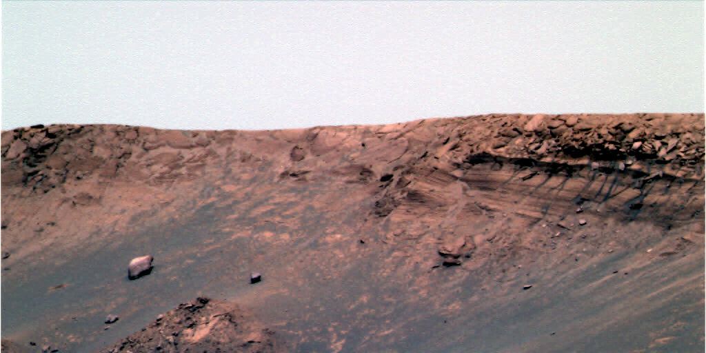
#137 Re: Life on Mars » Sheres are fossils not concreations. » 2004-05-06 18:33:17
Those Blueberries
...They stay atop the sand and dust due to saltation and low-density...
I'm not an expert of Saltation, but couldnd't you also suppose that the blueberries stay atop the sand and dust merely because the dust is being removed from beneath them by wind action? There probably isnt much soil sorting going on here. Any sand grains or dust next to a blueberry just gets blown away, but the blueberries remain. You might have some sand dunes covering over blueberry fields from time to time as they migreate, but generally the blueberries slow dust removal by acting like desert pavement, they stay at the top merely because everything else blows away, otherwise there should be lots of dust being kicked around in this area.
Closely related question: Are wind measurements being taken by the rovers? I haven't heard a peep about this...
#138 Re: Unmanned probes » Spirit & Opportunity *6* - continue on from thread "5" » 2004-05-06 14:50:14
What do you suppose the "twig" lying just in front of the "ice dunes" at the bottom of http://mars.gh.wh.uni-dortmund.de/mer/o … 6.jpg]this image in Endurance crater is? Is it sitting partially raised above the ground casting a shadow and showing a glimpse of sand under behind it or is it just a light area on the side of a rock facing us?
![http://mars.gh.wh.uni-dortmund.de/mer/o … 6.jpg]this](http://mars.gh.wh.uni-dortmund.de/mer/opportunity/096/1P136713914EFF2002P2293L5M1_L2L5L5L6L6.jpg]this)
#139 Re: Water on Mars » Closer view of springs inside Endurance crater. » 2004-05-06 14:39:41
I hope you are right. I would love to see springs.
From the gullies that MOC images have shown us, we know they are possible.
The leading theory is that the "gullies" are NOT formed by springs (that was the first hypothesis back in 2000 using MGS data (the "ice-dam" idea), the problem with this was that the "springs" come from high up in the crater walls, and there is no chance of a water table being this high)
The most likely hypothesis (using Oddyssey data from a couple years ago) is that the gullies are formed under a blanket of snow which is in turn underneath a blanket of dust (this snow theoretically still exists to this day right next to areas where it is all evaporated away and has revealed the gullies to us. the areas where snow still exists correspond to areas of less sunlight so it fits all the observations). So the sun slowly warms the snowpak, protecting the water beneath it from freezing, this allows it to melt and run down the slope under cover of the snowpack and carry debris away forming the gullies. Eventually the snowpack melts/evaporates away and reveals the gullies to the sky.
#140 Re: Unmanned probes » A puddle ? » 2004-05-06 14:06:23
[Hi Atomoid! I assume you were joking about NASA deliberately blurring out something we weren't supposed to see?! But, just to eliminate the possibility that our 'puddle' is no more than a transmission glitch, can any of our resident computer/image gurus tell from the JPL raw data whether the pixels are all 'kosher' in the area in question?
Thanks in anticipation.]
Amazing what you miss when your away for a few days...
Thats a great sequence of images over 3 days, cassioli. It seems NASA *was* very interested in it. but no comment yet...
I'm a bit more receptive to the idea that this is a puddle of frozen brine, perhaps going liquid during the day... However, i still think its probable that its just a "dust puddle" (whatever that really is and the whatever the physics of that entails im not so sure), it just seems its so unlikely for there to be water pooling up without much evidence left behind by it. wouldnt se see erosion or patterns left behind from the thaw/freeze cycles. such action would tend to move debris around as the water expands each phase and we should see circles and other geometric patterns like we see in the semi-permafrost regions here on Earth. Or perhaps these depressions themselves are "evidence" of this freeze thaw process, or even soil slumping into these "sink holes".
But i still think its most likely that the depressions are merely places where the impact-tossed bedrock chunks left behind sloping vacancies as the bedrock eroded away into the wind and the blueberries dropped out. At the bottom of this depression is the last flat surface remnant of this bedrock. Maybe if the local wind conditions are right the dust collects here and looks like this.
And Shaun, yes im being facetious in regards to those NASA conspiracy theories, regardless of the Brookings report (which basically implies that the (american) gov't Earth isnt ready for Contact yet so hush it up, although it is from the early sixties i think?) i really think that think if they found eveidence they couldnt keep a lid on it... thats why i was hoping for an independent ESA lander (Beagle) to provide some parity (or perhaps the black-ops has "taken care of" the "Beagle problem"...ha ha ha) unfortunately im not good enough with pixels to prove NASA malfeasance, but the compression artifacts certainly obfuscate the issue in question dont they...
#141 Re: Unmanned probes » A puddle ? » 2004-05-02 04:45:23
i used to think it might be a dust puddle, but why does this one look so different from the other ones? the other ones being the flat rock tops at the bottom of the divets in a lot of places between Eagle and here. the flatness coming from the wind eroding the bedrock chunk which leaves a vacancy left except for the few blueberrries that fall out of it and dont blow away. the other blueberries form a slope down to this vanishing point remnant of an eroding crater ejecta fragment. but this one is too smooth and anomalously flat
if it were water that would imply a water table very close to the surface and there shoudl be more evidence of such everywhere like in the crater bottoms and other low points, perhaps the ice-dune sculptures in the bottom of Endurance crater are related.
but most likely there lies some alien feature that the shadow government's black ops inside NASA has decided to replace with this compression artifacted and neutralled-out splotch since the world is not ready for the truth yet.
#142 Re: Unmanned probes » First view inside Endurance! - Wow... » 2004-05-01 21:48:35
Yes, entering on this side and slowly spiraling down is probably the best way to enter and exit the crater.
still sounds pretty risky, considering how much trouble it had on that little slope in Eagle crater, was it that it was slipping with all those ball bearings blueberries under its wheels? or just that the sand was loose and had no real bite and just fluffed out as the wheels spun? either way, it seemed to dig itself into quite a rut going up the side of that little slope, and this slope looks quite a bit more intimidating...
If they find it might be too risky to go in until they've circumnavigated the rim and checked out other areas of interest in the vicinity, then maybe while theyre at it they can go check out the heatshield impact zone which is just a tiny jaunt away from the other side of the crater to see if it gouged a deep groove for the MI to look into. it would also be interesting to see what kind of effects Mars entry had on the heatshield (this should prove to be good engineering feedback to optimize future heatshield designs, and would be the first such results from atmospheric entry on another planet).
#143 Re: Water on Mars » Artesian wells on Mars? » 2004-04-30 15:26:08
I had thought that, but if this is true, why have have I not seen this on the thousands of other pictures I have studied.
On Mars, when an impactor melts the subsurface ice, it forms a muddy mixture that flows out from all sides of the crater. To get a channel like these (Seems to be one per crater) the crater would fill with water until it hit breeched the crater at one point, and then flowing out this exit point.
What about after the impact event, the heat from the impact had melted some of the ground ice, and it starts to seep in the crater? Is that what you mean? I think that would be possible.
its hard to tell from the picture whether the craters are the source or the destination of the water, as in gusev the crater appears to be the destination.
if the crater were the source of the water, then inded it would apper to have breached an artesian water source. the sinuous channels should lead to some reservoir outside the crater which shoudl be a deep sediment bed like Meridiani.
But i wonder what would happen today on Mars would the water tend to signifficantly evaporate away before it could accumulate into a log-lasting sea or lake? or would it tend to accumulate a cover of ice protecting it from evaporation in the lake and increasing erosion in the channels? but in any case, lots of debris was moved via this channel and so the sediments should be pervasive and we shoudl see evidence of deltas or debris pans leading from this outflow channel (maybe there are some better pics of this area?)
#144 Re: Unmanned probes » What are the 'Blueberries" - What are the spheres Opportunity found? » 2004-04-29 13:42:14
...Even more puzzling is the even distribution of the spheres throughout the rocks
When we look at the layering in the rocks, the bottom layers were deposited first from the ancient sea (assuming they were deposited in a seabed) So we have ‘blueberries in the older layers.
If we move up the rock layers, the deposits get younger, yet we have sphere in those layers as well. This means that sphere are being evenly deposited (Or formed on the seafloor) in each time period, and the ones on the bottom are older than the ones on top (And if life did create them, then they have not evolved).
Or the spheres are all the same age and they formed after the layers were deposited.
Its possible that the layers formed very quickly, geologically speaking, layers deposited in faily quick succession, and that a large vertical column of layers remianed saturated until it dired up on a very quick timescale. When a uniformly saturated bed dries the minerals will precipitate out and these conditions should produce similar results throughout the vertical column.
Or i might be somewhat malinformed, the hematite blueberries necessarily need a long timscale to develop in? and therefore there shoudl be a greater size variant between them? im going on the assumption that they are the result of mineral concentration via evaporation rather than slow accretion (but im not a gelogist!) i guess im making the rash assumption that Mars atmosphere was close to vacuum before these layers were deposited and when these layers were created the water boiled off over a couple thousand years alowwing this concentration to take place on a short timescale. My other rash assumption is that the bedrock is very silty has very little "glue" holding it together (didnt get much time to develop a complex soil chemistry during the deposition event) so it breaks up readily and erodes very quickly into fine dust that gets almost completely removed from the area leaving a pavement of blueberries protecting the soils beneath from further erosion. please correct me if you see it otherwise as i have a low level of confidence in my above assumptions.
#145 Re: Water on Mars » Artesian wells on Mars? » 2004-04-29 13:02:11
Possibly here;
http://www.msss.com/moc_gallery/ab1_m04 … 304128.jpgNotice the channels running from several craters.
Could the impactors that formed these crater punched down to the water table (If one exists) To the south the land rises considerably. To get an artesian well, part of the water table needs to be higher than the exit point. If there was a water table starting in the higher southern region, it would run downhill, and then it would surface where ever an impactor punched down to it.
The image shows some sinuous channels, but It seems more likely that the impactors melted the subsurface ice and it flooded out carving the channels.
Artesian wells are often used to describe geysers and natural springs, differentiate this from an artesian *well*, where you actually drill beneath impermiable rock layers to create your own spring (and dont need to install a pump like in a non-artesian well). I think it might better be refered to as a spring or geyser.
However, it got me thinking that the conditions on Mars might be more conducive to artesian wells than they are on Earth. On Earth theres a lot of faults cracking and making plenty of escape routes for water tables to drizzle out as springs in many places tending to lessen the pressure except for a few situations where a slope of impermiable rock overlies a water table on the downward side of this you find artesian wells where there is some faulting. converseley on Mars, there should be a lesser concentration of faulting basically because theres apparently no ongoing tectonic activity, this would tend to make the water table sit higher and the few places where there is a fault would be the sources of artesian wells. On Earth, there are so many faults that mostly all you have are small springs. The problem with Mars is that it doenst rain, so the aqufers arent refilling like they do on Earth, so any artesian wells (or i should say springs) are likely to be ancient exhumed remnants. But if it were raining on Mars then id think we shoudl see many very large geysers at least until they erode out.
#146 Re: Unmanned probes » Results of Spirit and Opportunity - a quick question for my astronomy paper » 2004-04-28 01:39:18
NASA's http://www.jpl.nasa.gov/mer2004/news_ar … html]Press release site kind of gives a running list of news articles that you can go through item by item.
To sum it up, the Mysteries of Mars are being characterized in more and more detail every day. So far, all the digging, grinding, spectrometer readings and geological observations have lead to a few sweeping conclusions such as water existed "for sure" and for long enough to form sedimentary deposits (although this is still being challenged). Stay tuned, what we've learned so far is only knee-jerk formulation of some cursory observations, the most far-reaching theories have yet to be fleshed out by all the new data pouring in...
#147 Re: Unmanned probes » Spirit & Opportunity *6* - continue on from thread "5" » 2004-04-27 15:29:29
Fig Newtons: Cake or cookie? The debate rages on!
...i have always been perplexed by what Fig newtons are, but then they started making all sorts of different flavors and they just call them "Newtons" now. officially, nabisco says theyre "cookies". And then i read a National Geographic article in 1998 with big color pictures about fig wasps and it permanently ruined my appetite for eating anything fig-related. But as an unwitting child of the seventies the commercial of the singing fat guy in the fig suit is irreversibly burned into my brain (even more so than plop-plop-fizz-fizz) and it goes:
ooey gooey rich and chewy inside,
tender flaky golden cakey outside,
put the inside in the outside, and its good, darn tootin!
its the fig-fig newton!
here's the tricky part, the fig-fig newton!
one more time! the fig-fig newton!
(sorry to go off tangent in a "Mars" forum, but fig newtons have a very high energy per weight ratio so it could be argued that they might make a good "taste of home" food for settlers morale-support... really, i dont own stock in nabisco or anything, the generic brands were just as tasty)
#148 Re: Unmanned probes » Spirit & Opportunity *6* - continue on from thread "5" » 2004-04-27 04:26:06
Thanks for making that turntable 3D anim Luca (so you take the L and R images, decide on a focalpoint, and then horizontally align them to this point, then make a 2-frame animation of it?), that weird root-like object sticking up http://www.lyle.org/mars/imagery/1P1357 … .html]from sol 85 (and also in the http://www.lyle.org/mars/imagery/stereo … P.jpg]lyle 3D anaglyph) shows it has a very thin leg to stand on. if its not some sort of excavated mineralized hot spring outflow casing, then maybe its a remnant of a larger rock below the ground, almost all weathered away just leaving this hardest part of it. is it the blueberry bedrock? its hard to tell, from this perspective it looks more like jagged lava (but theres no lava here, right?)
![http://www.lyle.org/mars/imagery/1P1357 … .html]from](http://www.lyle.org/mars/imagery/1P135731612EFF1400P2283L7M1.JPG.html]from)
![http://www.lyle.org/mars/imagery/stereo … P.jpg]lyle](http://www.lyle.org/mars/imagery/stereo/1-135731612-P.jpg]lyle)
...while were waiting for Opportunity to view meow closeups of the "root", here are some some very odd & beautiful images: http://photojournal.jpl.nasa.gov/catalog/PIA05708]East Candor Layers
  http://photojournal.jpl.nasa.gov/catalog/PIA05739]Marte Valles Crater "Island"
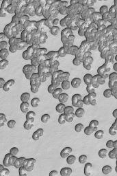 http://photojournal.jpl.nasa.gov/catalo … 742]Summer South Polar Cap
  http://photojournal.jpl.nasa.gov/catalog/PIA05748]North Polar Dunes
#149 Re: Unmanned probes » Spirit & Opportunity *6* - continue on from thread "5" » 2004-04-24 18:25:18
The plenty of spherules in opportunity's site is very impressive.
The http://jumpjack.altervista.org/immagini … PG]Pilbara anaglyph is interesting, but... look at http://marsunearthed.com/Opportunity/Op … D.GIF]THIS anaglyph!!! :band:Over soil, inside rocks, "at half way" between rocks and soil (when they are on stems)... they are EVERYWHERE!
It's defintely a strange planet!Luca
![http://jumpjack.altervista.org/immagini … PG]Pilbara](http://jumpjack.altervista.org/immagini/stems-anaglyph.JPG]Pilbara)
![http://marsunearthed.com/Opportunity/Op … D.GIF]THIS](http://marsunearthed.com/Opportunity/OpportunityGlyphs/Opportunity51_3D/Opportunity51_3D.GIF]THIS)
Thanks, this is truly an incredible image (indeed... planet!). The stems, of which i was so let down when they didnt MI close-up that big one in Eagle, are so much more plentiful here at Fram, now I hope we'll finally get those stem close-ups...
Why so many stems here? because it might be composed of newer debris? Are the stems merely the result of the wind blowing consistently from one precise angle over a long time period eroding everything but the leeward side around each blueberry and leaving these stem supports? In this case all the adjacent blueberry stems should point somewhat parallel, implying the same wind direction...
#150 Re: Unmanned probes » Spirit & Opportunity *6* - continue on from thread "5" » 2004-04-24 18:11:42
regarding the bright white glints on some rocks... look at this sol 105 R7]http://www.lyle.org/mars/imagery/2P135681876EFF3000P2552R1M1.JPG.html]"R7" image of the big rock glint just above where Cassioli pointed out that interesting circular feature (which i think might be an eroded concretion remnant, but that aside...).
![R7]http://www.lyle.org/mars/imagery/2P135681876EFF3000P2552R1M1.JPG.html]"R7"](http://www.lyle.org/mars/imagery/2P135681876EFF3000P2552R1M1.JPG.html)
The glint in the rock in this image is downright anomalous. Notice that there is no normal "whiting-out" of other areas of the image as would happen in a usual ccd oversaturation scenario, just the part of the rock where the glint is, it has to be a *very* bright glint to go out of gamut like this.
This is the "R1" image, look at the http://www.lyle.org/mars/imagery/2P1356 … .html]Left "L7" image and there is no glint (the different filter may have something to do with it). you'll notice that the glint is coming from an area that is a crack or groove in the rock. Might there be a crystal inclusion here glinting back exclusively at the angle in the R1 image? (unless its just a random data transmission dropout anomaly, but i highly doubt that). Spirit might have happened to spy the sun reflecting off a crystal face here.
![http://www.lyle.org/mars/imagery/2P1356 … .html]Left](http://www.lyle.org/mars/imagery/2P135681827EFF3000P2552L7M1.JPG.html]Left)